For a summary of main information known so far on the August 26th event in Nepal, please read our entry on EGU’s Hydrological Sciences blog.
News
Devastating earthquake-triggered flood in the Himalaya
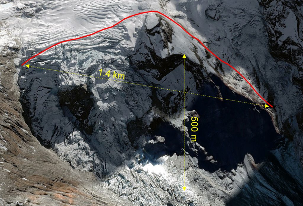
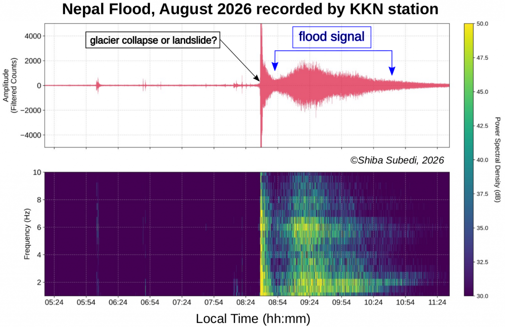
A devastating flash flood has hit Nepal and Tibet this morning. Hundreds are missing and rescue teams are challenged both in Rasuwa and further downstream in Nepal, and in Gyirong, Tibet. The flash flood was first reported to have been triggered by a nearby magnitude 4.4 earthquake — this is a usual, moderate size event for the region. Later reports from USGS indicate that a major landslide or glacier collapse was the cause of the first signal, with a magnitude equivalent to M5.2. In any case, the impact of the flash flood can be assessed on the records of the seismometer tens of kilometres away: after the short initial signal, the ground was vibrating for over two hours due to the flash flood. Credits: Shiba Subedi, NAST.

Thermal properties of the lower crust
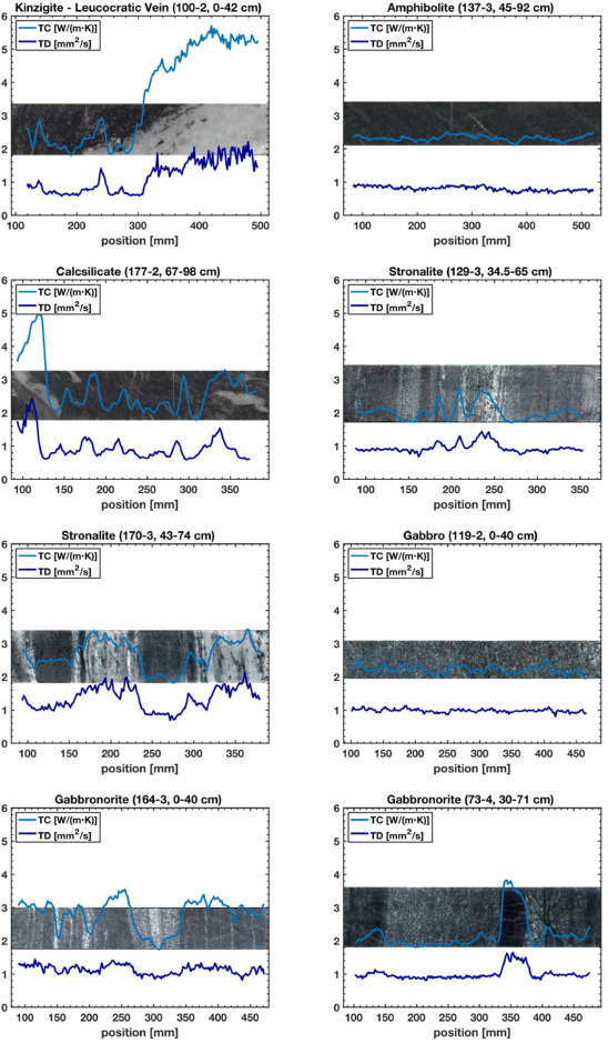
The temperature field in the Earth’s crust is one of the least constrained parameters, as there is no direct measurement possible beneath a certain depth, and as there is little data availabe on the properties of the relevant rocks. Thanks to the DIVE drilling project, we could sample, measure and characterize the thermal conductivity and heat production on a wide variety of rocks. These measurements, as the one on the figure below, connect the small-scale, mineral and rock properties, with the large-scale, crustal features. More details on these properties, and on their variability at various scales can be found in our fresh article by Lemke et al. (2026) published in the journal Geothermics.

Survey of the “Ovaille” landslides of 1584
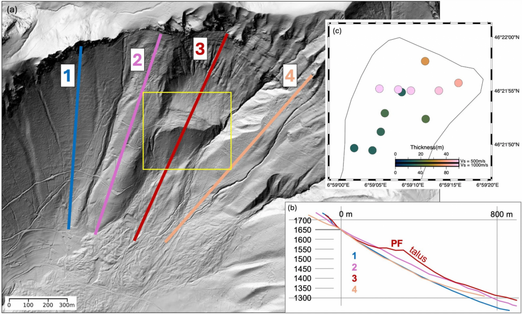
In March 1584, two earthquakes have triggered two massive mass movement events near the Eastern end of Lake Geneva, above Corbeyrier and Yvorne (canton of Vaud). Our study has investigated the traces of these events with geophysical and geological methods, to find out the thickness of the deposits, and their volume in the upper part at Plan Falcon. All details can be found in our freshly published paper by Maharaj et al. in the Swiss Journal of Geosciences. The study was co-funded by the Matterhorn grant of the Faculty of Geosciences and Environment (UNIL) and the Canton of Vaud.

New mantle transition zone map of central European orogens
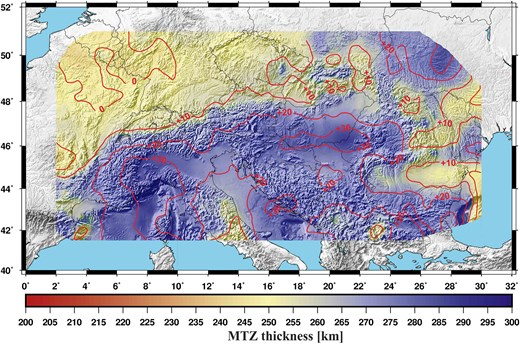
The mantle transition zone (MTZ), located typically between 410 and 660 km depth, is often preventing subducted slabs to directly sink further into the lower mantle. Beneath the orogenic belts of Central Europe, the Alps, the Carpathians and the Dinarides, only partial images of the MTZ were available so far. Now, thanks to the dense and longer term temporary passive seismic arrays such as AlpArray and PACASE, the MTZ beneath the entire region, and the enclosed Pannonian Basin, is imaged in 3D and high resolution. The results show that the slab graveyard at the bottom of the MTZ is continuous across the entire region – further details can be read in our recently published GJI paper (Kalmár et al. 2025).

A popular earthquake figure gets a major update
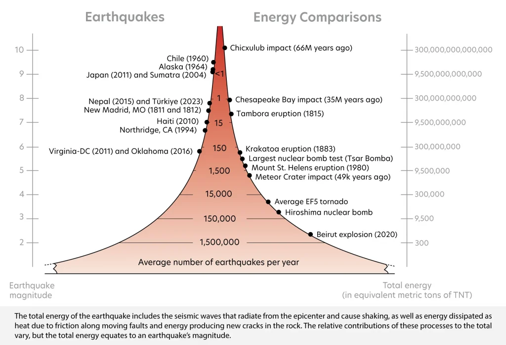
There is a classical figure to show while teaching on earthquakes, which shows what a given level of magnitude means in terms of energy or other processes. This figure is so popular that it will very likely look familiar to you.
During a recent work to prepare educational material for our programs in Switzerland and Nepal, it turned out that the widespread figure had an inconsistency: the left hand side on earthquakes showed only the energy radiated as seismic waves, while the right hand side on other events showed total energy. This has prompted a number of verification calculations and a major revision of the figure, so that it now compares comparable things, all in terms of total energy. Here it is below, and the short story of the revision can be read here.
A telling example of this update is the size of the largest bomb humans have historically created. In the previous diagram it was wrongly compared to a magitude 8 earthquake, but when correctly comparing total energy it is a magnitude 5.5.

DIVE borehole 5071_1_B results published
A key paper of project DIVE phase 1 has been recently published. The 578.5 m deep borehole has been fully cored, and numerous downhole logging datasets have been acquired. These provide a very rich, comprehensive overview of the middle portion of the continental lower crust at various spatial scales, and matches well the main lithologies recovered from the borehole. For full details, please read the paper by Li, Caspari, Greenwood et al.: “Integrated Rock Mass Characterization of the Lower Continental Crust Along the ICDP-DIVE 5071_1_B Borehole in the Ivrea-Verbano Zone” published in G-cubed.

Updated Geoscience Roadmap
Under the coordination of SCNAT, the Swiss science community has updated the respective roadmaps for large research infrastructure. These documents serve as basis for the process leading to the Swiss Roadmap for Research Infrastructures 2027 for the ERI Dsipatch 2029-2032. Further information on the community roadmaps are available HERE, and the Geosciences Roadmap is described HERE (direct access to the PDF).
DIVE public outreach event

Recent publications
The past summer has been productive in terms of publications.
Related to project DIVE, active seismic site surveys have been published for all three borehole locations: for holes 5071_1_A and _B in Greenwood et al., and for the planned hole in Val Sesia in Pasiecznik et al., nicely complementing results by Ryberg et al. last year.
On larger scales and passive seismic observations, the construction and operation of a large broadband network is demonstrated in Schlömer et al. for project PACASE in Eastern-Central Europe. One of the first seismic catalogues established from low-cost sensors only has been achieved by Subedi et al. in Nepal; the study is nicely summarized by the RaspberryShake here. Finally, how such observations serve seismotectonic interpretations is illustrated in Uthaman et al. on the area of Sikkim Himalaya; the study is highligted by the Editor at AGU’s Eos here.
In summary, seismology remains essential and the primary tool to investigate the internal structure of the Earth.