An overview of this deadly earthquake two weeks after it occurred has appeared in Nature news. There is limited information available, and a lot remains to be discovered.
Author: György Hetényi
Séisme 3.0
Depuis quelques temps une machine atypique accueille les visiteurs arrivant au Géopolis… elle s’appelle Séisme 3.0. Voici un article de présentation et d’explication ainsi qu’un vidéo.
Séminaires de la Prof. Romanowicz
La Faculté des Géosciences et de l’Environnement a le plaisir d’accueillir la Prof. Barbara Romanowicz (UC Berkeley et Collège de France) le 23 et 24 juin pour deux séminaires à l’Université de Lausanne:
Conférence public, le jeudi 23 juin à 17h15 (ANT-1129): Les grands tremblements de terre et les raz de marée: pourquoi, quand et comment?
Séminaire spécialisé, le 24 juin à 12h00 (GEO-2130): L’imagerie sismique de la Terre profonde: qu’avons-nous appris depuis 40 ans sur la structure et la dynamique interne de notre planète?
Opening of AlpArray Seismic Network data
Tomorrow – and it is not a joke – the entire AlpArray Seismic Network data will become publicly open.
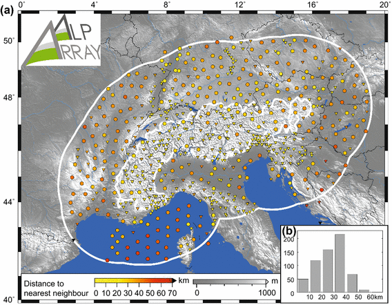
A few numbers to mark this event… July 2011: planning and coordination start. May 2015: Memorandum of Understanding signed between numerous universities and observatories. January 2016 to March 2019: 39 months of operation of the entire network. March 2022: several temporary seismological stations are still running, or have become permanent. The total data archive size is on the order of few dozens TeraBytes.
The AlpArray Seismic Network was one of the largest, simultaneously operated, broadband seismological networks in the academic domain, employing hexagonal coverage with station spacing as shown below.
Subductions in the Eastern Alps
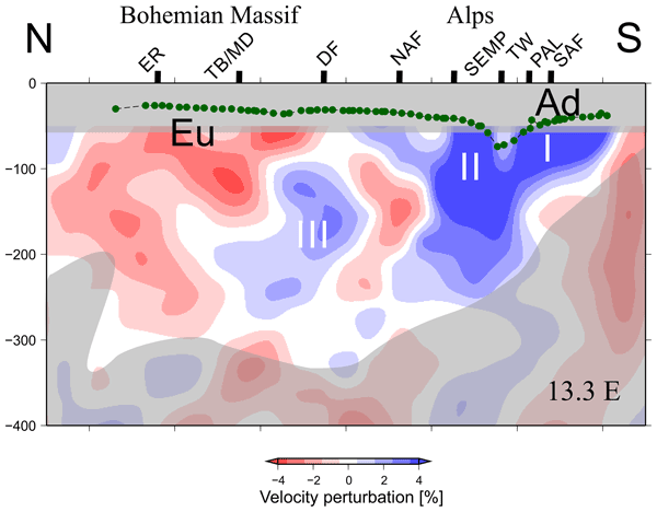
There is persistent debate on the direction and origin of subduction in the Eastern Alps: northward or southward, Adriatic or European plate. The most recent, high-resolution P-wave tomography shows the situation could be a subduction merger, with contribution of material from both sides. The idea is not new, as it has already been proposed 30 years ago, but the latest seismological data from the spatially dense AlpArray and EASI seismic networks allowed to create the sharpest images so far. Full details in our recent publication lead by Jarka Plomerová.
Fin de l’année commémorative du séisme de 1946
Aujourd’hui est la fin de l’année commémorative organisée à l’occasion du 75e anniversaire du dernier grand séisme en date en Suisse, celui du 25 janvier 1946 en Valais, avec une magnitude de 5.8. Au-delà du site web qui garde la trace des activités, un article dans Le Nouvelliste de ce matin résume nos actions, et notre article sur le Géoblog présente des archives inédites sur l’effet de ce séisme sur les différentes sphères de la Terre.
Nepal’s Earthquake Safety Day rhetoric contest
Around mid-January each year is Nepal’s Earthquake Safety Day. On occasion of the 24th such day (2022 in the western world, 2078 in the Nepali calendar), the Seismology at School in Nepal program has organized a rhetoric contest: videos up to 4 minutes long were to compete on the topic of “The role of schools in earthquake preparedness“. A total of 55 videos have been received, which is much above the expectations – congratulations to all participants on their motivation, and thank you for taking part. Below is a poster showing everyone who entered this contest. The top 3 performers have received an award: Aayushma Pokhrel, Samir Ahamad, and Anup Lamichhane. Congratulations!
Mountain Building special volume published
Over the past year a series of 12 articles related to orogeny have been published in frame of a special volume with the title Mountain Building. The volume is now complete and openly accessible to all. The contents can be downloaded either as individual articles, as a complete book in PDF, and even as an e-book (EPUB format). Many thanks to all contributors, reviewers and to Frontiers for hosting this work!
Year-closing fieldwork
Although the calendar year is still to end, good conditions for full-day fieldwork ended in October when setting back to Winter time. We used the last opportunity to return to the field, for the third time this year, and finished the measurement campaigns in a beautiful yet locally steep environment. Further details in 2022!
Precise location of the M8 earthquake in India in 1897
The late 19th century is the era known as the dawn of seismology: a few stations operate around the world and record waveforms on paper. Can you do real work with those data? Until now these data were considered insufficient or inaccurate. In our recent paper in The Seismic Record, we have recollected all original data, performed uncertainty analysis, and precisely calculated the seismological epicentre of the devastating earthquake that has hit the Shillong Plateau. The location confirms that the buried Oldham fault, previously suggested based on trigonometric survey data and geodetic modelling, is the source of this earthquake. The alternative scenarios, the earthquake happening on other long faults that are visible at the surface, have been ruled out. The results are likely the oldest instrumental locating of an earthquake.