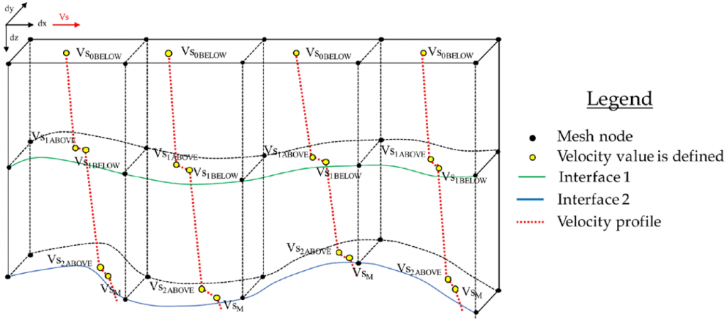
Following years of development, testing and validation, our new approach how to construct a crustal structure and shear-wave velocity model based on seismic receiver functions has just been published. The first part of the paper explains the methodology, the second applies it to the Central Alps and the AlpArray dataset. One key element is the new model parameterization, shown below.
DIVE DT-1b at 175 metres
Three weeks into the drilling phase of DT-1b, the hole’s current bottom is at 175 m below surface. There have been smooth and efficient days with night shifts, other days with more or less improvisation, rig change, minor fracture zone, and other adventures. The weekly shifts rotate and we look forward to a first logging session in the coming weeks.
![]() | ![]() |
DIVE drilling DT-1b Ornavasso started
On October 6th 2022, the first hole (DT-1b) of project DIVE has started the drilling operations just outside Ornavasso. Bedrock was encountered within a meter from the surface, as predicted by subsurface geophysical surveys by MUL. Partners from numerous countries gather on site to set the routine workflow in the coming days. Updates can be followed at THIS ICDP weblink.

Widely felt earthquake near Basel
On Saturday 10.09.2022 a magnitude 4.7 earthquake happened 15 km from Basel, towards Mulhouse (France). The shaking has been widely felt in Switzerland, all across the plateau, and in a large part of the Alps. So far there are no news of damages. A summary in German and French is available on the news page of the Swiss Seismological Service, and the RTS Téléjournal has reported on the event on Sunday. The closest low-cost seismometer of the school seismology network has recorded the following waveform in Bienne/Biel, and here is a figure showing all recordings at schools.

Liechtenstein earthquake hits parliament’s quake-insurance debate
There are rare events in nature. Today the Liechtenstein parliament was debating the matter of earthquake insurance. Exactly at that time, first a magnitude 2.1, then 32 seconds later a magnitude 3.9 earthquake has shaken the building. The session was temporarily interrupted and the chamber evacuated. (Source: euronews). Here is a video about the event:
Afghanistan earthquake, two weeks situation
An overview of this deadly earthquake two weeks after it occurred has appeared in Nature news. There is limited information available, and a lot remains to be discovered.
Séisme 3.0
Depuis quelques temps une machine atypique accueille les visiteurs arrivant au Géopolis… elle s’appelle Séisme 3.0. Voici un article de présentation et d’explication ainsi qu’un vidéo.
Séminaires de la Prof. Romanowicz
La Faculté des Géosciences et de l’Environnement a le plaisir d’accueillir la Prof. Barbara Romanowicz (UC Berkeley et Collège de France) le 23 et 24 juin pour deux séminaires à l’Université de Lausanne:
Conférence public, le jeudi 23 juin à 17h15 (ANT-1129): Les grands tremblements de terre et les raz de marée: pourquoi, quand et comment?
Séminaire spécialisé, le 24 juin à 12h00 (GEO-2130): L’imagerie sismique de la Terre profonde: qu’avons-nous appris depuis 40 ans sur la structure et la dynamique interne de notre planète?
Opening of AlpArray Seismic Network data
Tomorrow – and it is not a joke – the entire AlpArray Seismic Network data will become publicly open.
A few numbers to mark this event… July 2011: planning and coordination start. May 2015: Memorandum of Understanding signed between numerous universities and observatories. January 2016 to March 2019: 39 months of operation of the entire network. March 2022: several temporary seismological stations are still running, or have become permanent. The total data archive size is on the order of few dozens TeraBytes.
The AlpArray Seismic Network was one of the largest, simultaneously operated, broadband seismological networks in the academic domain, employing hexagonal coverage with station spacing as shown below.

Subductions in the Eastern Alps
There is persistent debate on the direction and origin of subduction in the Eastern Alps: northward or southward, Adriatic or European plate. The most recent, high-resolution P-wave tomography shows the situation could be a subduction merger, with contribution of material from both sides. The idea is not new, as it has already been proposed 30 years ago, but the latest seismological data from the spatially dense AlpArray and EASI seismic networks allowed to create the sharpest images so far. Full details in our recent publication lead by Jarka Plomerová.


