VGC 2021 conference
From 29th September to 1st October 2021 took place the 4th edition Virtual Geoscience Conference. Some of us seized the opportunity to present there ongoing work and project. A- Lidia …
VGC 2021 conference Read MoreDisaster Risk Reduction, Hazard Assesment, and Risk Analysis

From 29th September to 1st October 2021 took place the 4th edition Virtual Geoscience Conference. Some of us seized the opportunity to present there ongoing work and project. A- Lidia …
VGC 2021 conference Read MoreAbstract: Laser scanning or LiDAR has been revolutionary for landslide research because it provides high-resolution 3D topography, which allows for characterizing all types of landslides in more detail. The major …
Landslide analysis using laser scanners Read MoreExciting Summer!! On 25 – 27 August 2021, The second fieldwork monitoring at La Grave, France was carried out by Michel Jaboyedoff as the Head of Risk Group Team, and …
2nd La Grave, France monitoring fieldwork Read MoreOn August 23, with some colleagues of the Institute of Earth Surface Dynamics, we had the pleasure to go at the cabin of the Dent Blanche in the Hérens valley. …
Dent Blanche laser scanning campaign Read MoreThe risk group had the pleasure to welcome two civil servants during some weeks. Naël Dillenbourg and Taavet Kangur are both presently students in microtechnics and robotics at EPFL. During …
Two visiting civil servants in electronics Read MoreIt has been decided to start a new and challenging project : Scanning the main cliffs in the heart of the Mont Blanc massif to start an inventory. The aim …
Lidar acquisitions of the main spots of the Mont Blanc massif Read More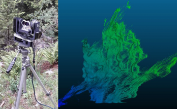
La recherche de solutions d’équipement à faible coût en géomatique et dans d’autres domaines est un thème abordé par un nombre croissant de chercheurs. Aujourd’hui, les ressources open-source du web, …
Cristiano Gygax: Scanner LiDAR terrestre à faible coût basé sur Arduino Read More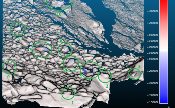
Ce travail de recherche s’intéresse à l’utilisation de la Mono-photogrammétrie (Mono-P) en tant que méthode de suivi de mouvements gravitaires dans un environnement rocheux. La Mono-P relie les données orthorectifiées …
Céline Cardot: La Mono-photogrammétrie comme méthode de suivi des mouvements gravitaires: évaluation du potentiel et des limites Read More
Le but de ce travail est d’étudier l’évolution en surface du glissement du Pont Bourquin. Actif depuis 2004, il affecte des unités de gypse, flysch et schistes. D’une profondeur de …
Marc Auer: Monitoring multi-technique du glissement de terrain du Pont-Bourquin (Les Diablerets) Read MorePar ailleurs, j’ai participé à une journée organisée par l’IGD et la PLATEFORME SOCIÉTÉ NATURE – Vendredi 27 avril 2018 – Université de Lausanne, où j’ai défendu la thèse suivante : …
Jabo’s corner: Exposé donné lors la journée consacrée à « Une recherche environnementale engagée ? » Read MoreMichel Jaboyedoff1, Pascal Horton1, Marc-Henri Derron1, Céline Longchamp1, Clément Michoud11University of Lausanne, Lausanne, Switzerland Jaboyedoff M., Horton P., Derron MH., Longchamp C., Michoud C. (2013) Monitoring Natural Hazards. In: Bobrowsky …
Monitoring Natural Hazards Read More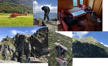
From July, 26th to August, 6th, 4 of us travelled to Acquarossa for data acquisition and material installation over the Cima del Simano instability (Val di Blenio). Despite very bad …
2 weeks fieldtrip at Cima del Simano (Ticino) Read More