
Antoine Guérin led a very innovative research financed by the SNSF Grants#: 200021_127132, 200020_146426, and 200020_159221, dedicated to rockfall hazard based on rockfall sources area statistics and thermal imaging. The importance of this research has been acknowledged in the Horizon SNF magazine.
The PhD title is:
Novel approach for quantifying rockfall and rock mass failure: point cloud analysis of pluri-decennial rockfall activity and characterization of thermally induced rock deformation
Abstract
Rockfalls and rock mass failures are often a primary driver of geomorphic change in mountainous settings. Rock mass failures pose significant hazard and risk, since even in the case of small-size events, rockfalls sometimes seriously damage transportation corridors and their infrastructures, sometimes interrupting roads and railway traffics for several months or years. Mountain communities are not spared from this hazard and risk either, since each year, the world’s media report events that have reached urban and tourist areas, sometimes resulting in human fatalities. Although historical rockfall inventories exist and some of them are regularly updated, these databases often present gaps (e.g., observation and quantification biases) and characterizing rockfall activity (in terms of location and frequency) from this data remain challenging. In addition to providing data on rockfall occurrence and volume, some historical inventories also offer valuable information about the probable environmental triggers of rockfall events. Analysis of these triggers revealed that even though most documented rockfalls occur due to precipitation-related seepage into rock fractures, a certain number of events without recognized triggers (sometimes including large volumes) occur in summertime, on sunny days and at the hottest hours of the day, suggesting that thermal effects play a significant role in the triggering of rockfalls.
To overcome the limitations associated with historical rockfall inventories and further investigate environmental thermal forcing in rock, a multidisciplinary approach that benefits from the advantages of different techniques and sources of information has been adopted during this PhD thesis, including in-situ instrumental measurements, remote sensing and 2-D thermal modeling. For this purpose, a novel approach for quantifying multi-decadal rockfall activity and characterizing thermally induced rock deformation, has been developed using: (1) long-term terrestrial laser scanning (TLS) monitoring; (2) structure-from-motion (SfM) methods applied to archival pictures; and (3) highfrequency intraday infrared thermography (IRT) surveys.
The first part of the manuscript is dedicated to monitoring of granitic rock faces located within the Mont Blanc massif (Haute-Savoie, France) and Yosemite Valley (California, USA). This research presents a unique inventory of more than 500 rockfall sources, including 308 in the Mont Blanc massif (2005-2016 period) and 235 in Yosemite Valley (19762017 period). This inventory provides new insights into rockfall frequencies and retreat rates that shape the granitic rock faces of medium and high altitude. In particular, the 11 years of TLS monitoring performed in the Mont Blanc massif enabled very accurate characterization of the progression of a new state of stability of a rock face affected by a major rockfall event of nearly 300,000 m³, in June 2005. Similarly, the 3-D reconstruction of former topography using archival imagery, allowed to “wind back the clock” and to quantify 40 years of rockfall activity in two adjacent cliffs of Yosemite Valley. In this way, we have been able to relate more precisely past and recent rockfall activities, to detect the rockfall scars still active, and to determine the weakness areas of the investigated rock cliffs. Additionally, the high-frequency SfM survey performed in Yosemite Valley during the autumn of 2017, allowed characterizing an entire very active rockfall sequence, which unfortunately left one person dead and one injured. A retrogressive erosion dynamic system with increasing rockfall volumes similar to that identified in the Mont Blanc massif was observed, suggesting potential similarities between the erosion processes involved in the landscape evolution of granitic rock faces.
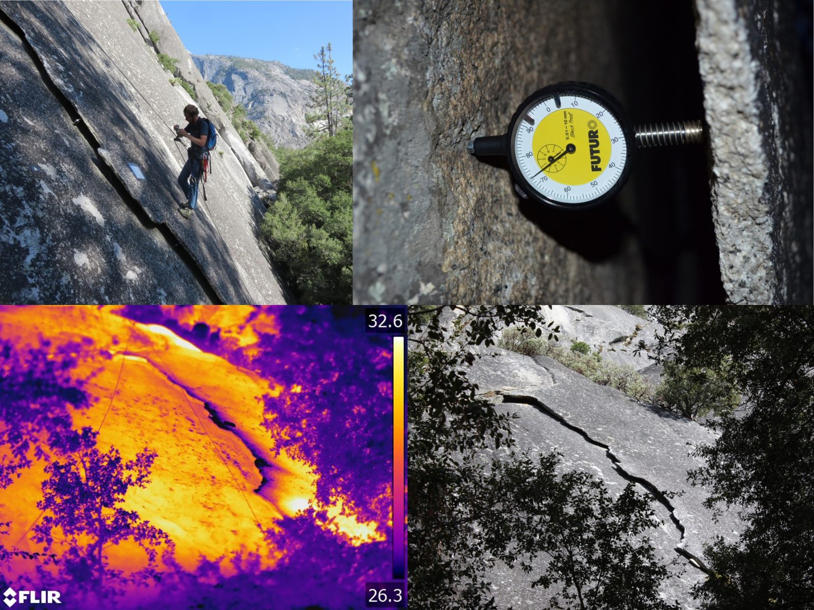
The second part of the manuscript is dedicated to infrared thermal characterization of partially detached rock sheets and exfoliated granitic rock faces. This research, conducted in its entirety in Yosemite Valley, enabled to characterize and image a complete thermally induced rock deformation cycle (i.e., over 24 hours), and to determine new relationships between daily thermal changes and rock face deformation. Thus, for the first time, the daily millimetric deformation pattern of partially detached rock sheets could be directly compared to their diurnal and nocturnal thermospatial signatures. Our analyses indicate that the most deformed portion of the rock sheets coincides with the area where both the fracture aperture and the temperature variations are greatest.
Furthermore, the hundreds of IRT images acquired on exfoliated rock faces as part of this work have revealed that partially detached rock sheets exhibited a nocturnal thermal signature colder than the surrounding rock. This innovative finding, independent of the rock sheet size, offers a new method for remote detection of partially detached rock sheets. In addition, the penultimate chapter of this PhD thesis illustrates the strong potential of the TLS-IRT coupling for investigating potential rockfall sources on exfoliating cliffs, especially since we demonstrated with 2-D thermal modeling that the presence of local warmer areas on the surface of rock sheets could be due to the presence of rock bridges that keep the rock in a state of at least temporary stability.
The research undertaken in this PhD thesis aimed to take advantage of historical SfM methods, long-term TLS monitoring and high-frequency IRT surveys, to propose a new and efficient approach to characterize rockfall activity and rock mass failures. Historical terrain models derived from archival imagery now provide the opportunity to reassess the volumes of the large rockfalls that occurred during the 20th century. Coupled with current monitoring, this approach enables both correction and completion of historical rockfall inventories, and for the determination of volume-frequency relationships that are more accurate and more representative of rockfall activity that controls the erosion of rock faces. The remote thermal detection of rock bridges and partially detached rock sheets are significant advances that open up new perspectives for improving rockfall susceptibility, hazard analyses and hazard mitigation in mountainous landscapes.
Publications
- Guerin, A.,Ravanel, L., Matasci, B., Jaboyedoff, M., & Deline, P. (2020): The three-stage rock failure dynamics of the Drus (Mont Blanc massif, France) since the June 2005 large event. Scientific Reports, 10(1), 17330, 20 p.
- Guerin, A.,Jaboyedoff, M., Collins, B. D., Stock, G. M., Derron, M.-H., Abellán, A., & Matasci, B. (2020): Remote thermal detection of exfoliation sheet deformation. Landslides, 18(3), 865-879.
- Guerin, A.,Stock, G. M., Radue, M. J., Jaboyedoff, M., Collins, B. D., Matasci, B., Avdievitch, N., & Derron, M.-H. (2020): Quantifying 40 years of rockfall activity in Yosemite Valley with historical Structure-from-Motion photogrammetry and terrestrial laser scanning. Geomorphology, 356, 107069, 19 p.
- Guerin, A.,Jaboyedoff, M., Collins, B. D., Derron, M.-H., Stock, G. M., Matasci, B., Boesiger, M., Lefeuvre, C., & Podladchikov, Y. Y. (2019): Detection of rock bridges by infrared thermal imaging and modeling. Scientific Reports, 9(1), 13138, 19 p.
- Guerin, A.,Abellán, A., Matasci, B., Jaboyedoff, M., Derron, M.-H., & Ravanel, L. (2017): Brief communication: 3-D reconstruction of a collapsed rock pillar from Web-retrieved images and terrestrial lidardata–the 2005 event of the west face of the Drus(Mont Blanc massif). Natural Hazards and Earth System Sciences, 17(7), 1207–1220.
- Guerin, A.,Nguyen, L., Abellán, A., Carrea, D., Derron, M.-H., & Jaboyedoff, M. (2015): Common problems encountered in 3D mapping of geological contacts using high-resolution terrain and image data. European Journal of Remote Sensing, 48(1), 661–672.
- Guerin, A.,Hantz, D., Rossetti, J. P., & Jaboyedoff, M. (2014): Brief communication” Estimating rockfall frequency in a mountain limestone cliff using terrestrial laser scanner”. Natural Hazards and Earth System Sciences Discussions, 2(1), 123–135.
- Stock, G. M., Guerin, A.,Avdievitch, N., Collins, B. D., & Jaboyedoff, M. (2018): Rapid 3-D analysis of rockfalls. GSA Today, 28(8), 28–29.
- D’Amato, J., Hantz, D., Guerin, A.,Jaboyedoff, M., Baillet, L., & Mariscal, A. (2016): Influence of meteorological factors on rockfall occurrence in a middle mountain limestone cliff. Natural Hazards and Earth System Sciences, 16(3), 719–735.
- Hantz, D., Colas, B., Dewez, T., Lévy, C., Rossetti, J.-P., Guerin, A.,& Jaboyedoff, M. (2020): Caractérisation quantitative des aléas rocheux de départ diffus. Revue Françaisede Géotechnique, 163(2), 8 p.
- Matasci, B., Stock, G. M., Jaboyedoff, M., Carrea, D., Collins, B. D., Guerin, A.,Matasci, G., & Ravanel, L. (2018): Assessing rockfall susceptibility in steep and overhanging slopes using three-dimensional analysis of failure mechanisms. Landslides, 15(5), 859–878.