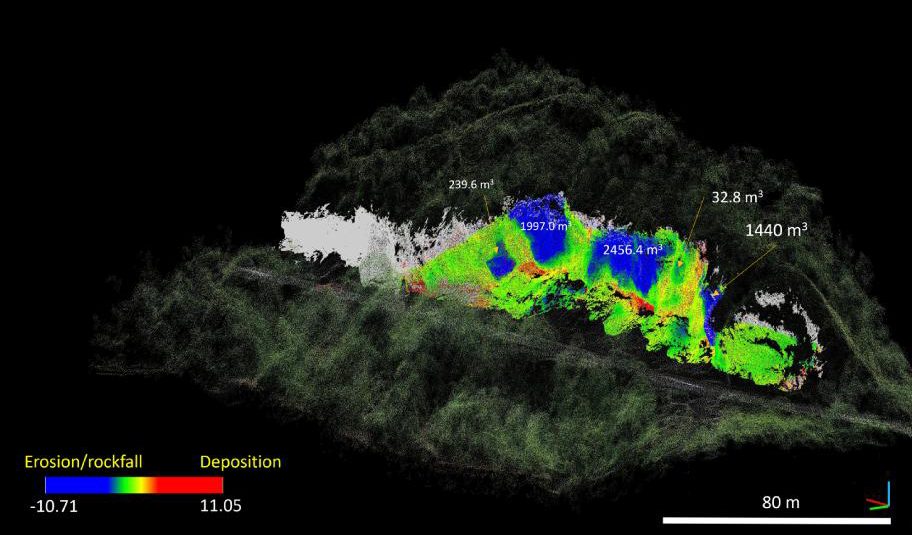
due to erosion or rockfalls; red indicates positive volume change due to deposition. (in: Choanji, T., Jaboyedoff, M., Yuskar, Y., Samsu, A., Fei, L. and Derron, M.H., 2025. Evolution of rockfall based on structure from motion reconstruction of street view imagery and unmanned aerial vehicle data: case study from Koto Panjang, Indonesia. Remote Sensing, 17(11), p.1888.)
Tiggi Choanji
Director: Prof. Dr. Michel Jaboyedoff,
Jury: Prof. Dr. Luuk Dorren, Prof. Dr. Dwikorita Karnawati
Doctoral dissertation in Earth Sciences, defended on September 24, 2026, by Tiggi Choanji, affiliated with the Institute of Earth Sciences (ISTE) at the FGSE.
ABSTRACT
Rockfall is among the most pervasive and unpredictable hazards affecting steep terrain, posing a persistent threat to infrastructure, settlements, and cultural heritage in mountainous and cliff-bound environments worldwide. Driven by the progressive weakening of rock masses through structural discontinuities, weathering, and climatic forcing, rockfall events range from small, frequent detachments to rare but high-magnitude failures, making their prediction and management a considerable challenge. Despite decades of research, characterising rockfall hazard remains difficult in settings where historical records are sparse, access is limited, underscoring the need for accessible, scalable, and quantitative approaches to hazard assessment. This thesis addresses this challenge through a multi-method, multi-scale characterisation of rockfall processes across three contrasting case studies, spanning an open tropical cliff face, an Alpine transport corridor, and a historically excavated tunnel. Each case study integrates remote sensing techniques, including street view imagery, unmanned aerial vehicle photogrammetry, and terrestrial laser scanning, with structural, kinematic, and numerical modelling to quantify rockfall volume, frequency, and spatial distribution, and to identify the geomechanical and meteorological controls governing detachment. In Indonesia, repeated imagery acquired through cost-effective platforms enabled the reconstruction of cliff retreat over several years, revealing the structural controls on instability and the role of slope morphology in governing rockfall runout and exposure to nearby infrastructure. Along an Alpine road corridor, an inventory of observed impacts was combined with large-scale trajectory simulations to demonstrate that integrating field evidence with process-based modelling substantially improves the spatial delineation of hazard along transport routes. Within a historically carved tunnel in Switzerland, terrestrial laser scanning monitoring, fragment morphology analysis, discontinuity mapping, and finite element modelling together revealed that block-scale rockfall detachment can persist even where the surrounding rock mass remains globally stable, highlighting a fundamental distinction between local and structural failure regimes.
Collectively, these case studies demonstrate that accessible remote sensing platforms, when combined with structural, kinematic, and numerical analysis, provide a robust and transferable framework for quantifying rockfall hazard across diverse geological and infrastructural settings, including those lacking historical monitoring records. v The findings emphasise the central role of discontinuity geometry, slope morphology, and meteorological triggering in governing rockfall behaviour, with direct implications for hazard mitigation and the conservation-compatible management of both transport infrastructure and geoheritage sites.