
Active mountain fronts are subject to large scale slope collapses which have the capacity to run long distances on piedmont areas. Over time, fluvial activity and other gravitatory processes can intensively erode and mask primary features related to the collapses. Therefore, to reconstruct the history of their occurrence, further analyses are needed, like sedimentologic analyses. This work focuses on the occurrence of large rock avalanches in the Vinchina region, La Rioja (28°43’27.81” S / 68°00’25.42” W) on the western side of the Famatina range (Argentina). Here, photointerpretation of high-resolution satellite images (Google Earth) allowed us to identify two rock avalanches, with their main scarps at 2575 and 2750 masl. There are no determined absolute ages for these deposits, however by comparing their preservation degree with those dated further north (in similar climatic and landscape dynamics contexts), we can suggest these rock avalanches took place during the Pleistocene.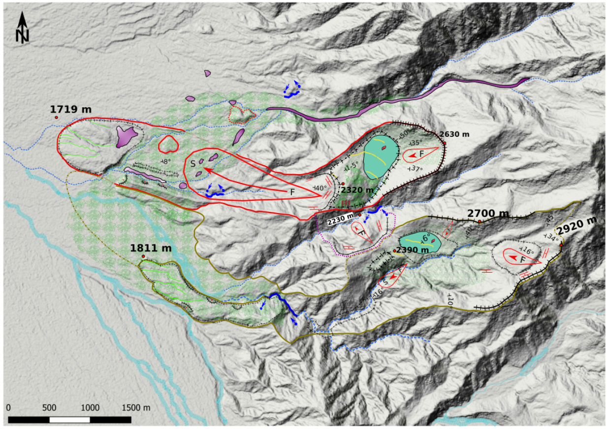 We carried out a fieldwork survey in this remote area, including classical landslide mapping, structural analysis, deposits characterization and sampling. The deposits reach the valley bottom at around 1700 masl. with runouts about 5 km and 5.3 km long. In one of the cases, the morphology of the deposit is well preserved, allowing to accurately reconstruct its extension. However, in the second case, the deposits are strongly eroded by sources draining from the mountain front, therefore further analyses should be done to reconstruct its extension. In addition to morphologic interpretations, a multiscale grainsize analysis was done to di?erentiate rock avalanches from other hillslope deposits: first 3D surface models of surface plots (5x5m) were built with SfM (structure from motion) photogrammetry; then classical sieving and finally laser grain-size analysis of deposits were performed. Samples were collected on different parts of the slope, but also along cross sections throughout the avalanche deposit. This deposits characterization was combined with results from mapping and image analysis to provide a first description of the sequence and the extension of events related to the evolution of this mountain front. The collected data helped to create a series of propagation models with the software DAN3D, developed by Hungr (2009). We chose a Voellmy rheology for the model with f = 0.10 ± 0.05 and ? = 100 (m/s2) ± 50 (m/s2) for the rock avalanches and f = 0.10 ± 0.05 and ? = 500 (m/s2) ± 200 (m/s2) for the debris flow. The results show a good propagation with more dispersion that we can see on the field. Part of the cover on the numerical model is not visible on the field, probably due to erosion and transport having moved the material, resulting in the current landscape.
Author: José Pullarello
Director: Marc-Henri Derron, Michel Jaboyedoff.
External Supervisor: Ivanna Penna.