Skip to content

RISK Group

Disaster Risk Reduction, Hazard Assesment, and Risk Analysis

  • Home
  • People
    • Team
    • Master students
    • Alumni
    • Group Map
  • Research
    • Main Research Themes
    • Current Projects
    • Completed Projects
  • Ongoing
    • News
    • Blog
    • Gallery
    • Media
    • Corner
      • Marc-H’s corner
      • Jabo’s Corner
      • Manu’s corner
      • Zenan’s corner
  • Publications
    • List of Publications
    • Mémoire SVSN
    • EPIC Eco-Safe roads
  • Resources
    • Teaching
      • Online Resources
    • Software
      • AtmoSwing
      • Coltop3D
      • Conefall
      • Flow-R
      • Histofit
      • PimpMyRockyfor
      • TSiNaHa
      • 3DPointCloudToolBox
    • Lab Facilities and Equipment
  • Events
    • VGC 14
    • Workshop 10 years FGSE
    • JRDN 2011
    • Slope Tectonics 2008
    • Workshop on risk 2005
    • JRDN 2007
    • Journée de rencontre (ISTE)
  • Contact
Main Menu
  • Home
  • People
    • Team
    • Master students
    • Alumni
    • Group Map
  • Research
    • Main Research Themes
    • Current Projects
    • Completed Projects
  • Ongoing
    • News
    • Blog
    • Gallery
    • Media
    • Corner
      • Marc-H’s corner
      • Jabo’s Corner
      • Manu’s corner
      • Zenan’s corner
  • Publications
    • List of Publications
    • Mémoire SVSN
    • EPIC Eco-Safe roads
  • Resources
    • Teaching
      • Online Resources
    • Software
      • AtmoSwing
      • Coltop3D
      • Conefall
      • Flow-R
      • Histofit
      • PimpMyRockyfor
      • TSiNaHa
      • 3DPointCloudToolBox
    • Lab Facilities and Equipment
  • Events
    • VGC 14
    • Workshop 10 years FGSE
    • JRDN 2011
    • Slope Tectonics 2008
    • Workshop on risk 2005
    • JRDN 2007
    • Journée de rencontre (ISTE)
  • Contact

Tag: Susceptibility

Rockfall susceptibility mapping
Projects_completed

Advanced Susceptibility Mapping for Natural Hazards in the Swiss Alpine Valley of Bagnes

November 5, 2013November 11, 2013

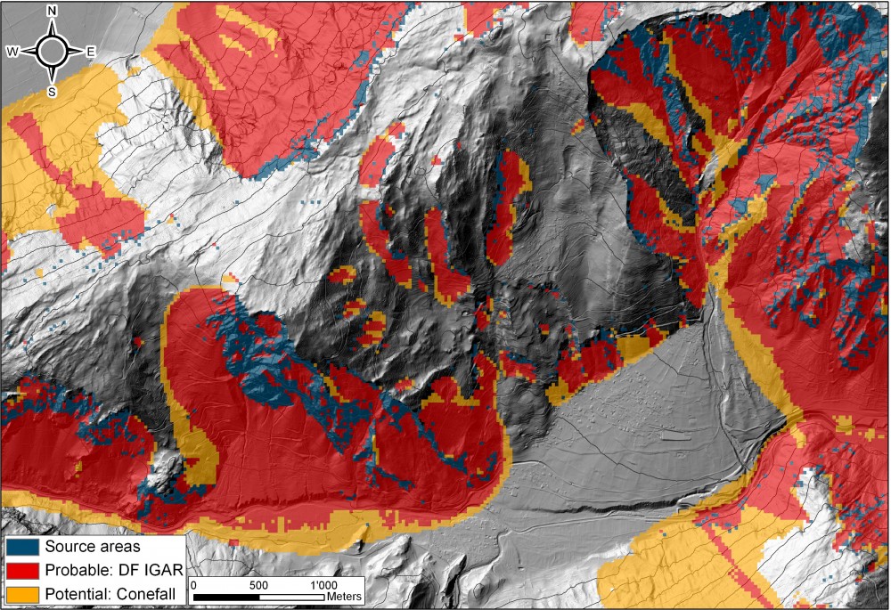
Alpine municipalities are exposed to numerous natural hazards, such as snow avalanches, rockfalls, landslides and debris flows. The Bagnes and Vollèges municipalities in Valais (Switzerland) lie between 600 m and 4200 …

Advanced Susceptibility Mapping for Natural Hazards in the Swiss Alpine Valley of Bagnes Read More

Archives

Total Views: site stats

Categories

LINKS

Faculty of Geosciences and Environment

University of Lausanne

Copyright @ 2021 by Risk Group
Powered by WordPress and HitMag.