
Lidia Loiotine
Directors: Prof. Dr. Michel Jaboyedoff, Prof. Dr. Mario Parise
Jury: Prof Federico Agliardi, Dr. Marc-Henri Derron, Prof Marie-Elodie Perga
Rock mass failures pose significant hazards and risks to society and can seriously damage the anthropogenic infrastructures or the natural, cultural or historical heritage of protected sites and, most of
all, human lives, even when they involve small volumes of rock. Although large volumes are typically
mobilized in mountainous areas, several episodes sporadically occur in coastal cliffs, also as a consequence
of the on-going climate changes. The risk is particularly high when instability processes take
place in urban or tourist area.
Both traditional and most advanced methods for landslide hazard assessment in rock slopes necessitate
a full understanding of the overall rock mass behavior and of the on-going endogenic and exogenic
processes. Given the anisotropic, inhomogeneous, discontinuous, and non-elastic nature of
rock masses, stability analyses necessarily require appropriate rock mass characterization. Discontinuities
play a key role in the mechanical behavior of rock masses, and their detection and quantitative
description represent one of the most challenging aspects of hazard assessment.
Several remote sensing techniques have been introduced in geoscience to support the conventional,
dangerous and time-consuming field surveys, and their application is increasing exponentially. However,
because of the intrinsic complexity of rock masses, a comprehensive standard procedure for
rock mass characterization and hazard assessment, involving both conventional field surveys and remote
sensing techniques, has not yet been proposed.
The main goal of this PhD thesis is to investigate the applicability of remote sensing methods for rock
mass characterization in complex environments, with focus on their integration with the irreplaceable
conventional geostructural and geomechanical surveys, in order to set-up advanced geomechanical
models for sophisticated stability analyses.
- The first part of this manuscript is of informative type and provides a solid background of the
techniques and methods (e.g. discontinuity characterization, rock mass classification systems, failure
mechanisms, and application of remote sensing techniques) faced throughout the document, as well
as an outline of the research approach. - The second part of this thesis concerns the testing, validation and optimization of different remote sensing techniques for rock mass characterization, and presents an innovative digital tool for 2-D analyses of discontinuities. More in detail, the first topic addressed in this part is a critical review of the most used remote sensing techniques for rock slope investigation in complex conditions: TerrestrialTerrestrial Laser Scanning (TLS), terrestrial and Unmanned Aerial Vehicle (UAV) Structure from Motion techniques, and InfraRed Thermography (IRT). A coastal case study affected by complex morphology, with intense development of karst and weathering processes, presence of mediterranean vegetation, in a context heavily frequented by tourists, was selected to carry out these researches. In detail, a quantitative comparison of the first three methods for rock slope characterization from point clouds, with particular reference on their accuracy for discontinuity extraction and characterization, as well as for rock slope monitoring, is presented. It was found out that point clouds generated from terrestrial or UAV-based photogrammetry are prone to “distortions” if control points cannot be evenly distributed on the field because of morphological constraints. As concerns the accuracy, terrestrial photogrammetry by means of common digital cameras can be used for a preliminary characterization, whilst TLS and UAV have similar accuracies. The use of one technique rather than the other for monitoring purposes depends on the objectives of the survey: whilst TLS provides more accurate deformation measurements and rockfalls volume estimations, UAV systems cover larger area, and allow an easier interpretation by direct comparison with high-resolution photos. This aspect is important in rock masses where shrubs are not easily recognizable on the point clouds. As concern the discontinuity characterization, the three point clouds provided approximately the same results, however the UAV technique was found to be more reliable because it was not affected by occlusions (shadow areas). This part of the manuscript presents a critical analysis of the advantages and limitations not only of different remote sensing techniques, but also of different platforms (e.g. hand-held cameras or UAV systems). Although some papers on the use of remote sensing techniques for rock mass characterization are reported in the literature, this part of the thesis focuses on their quantitative comparison and on their optimization in carbonate and coastal environments, which are subjected to particular issues.
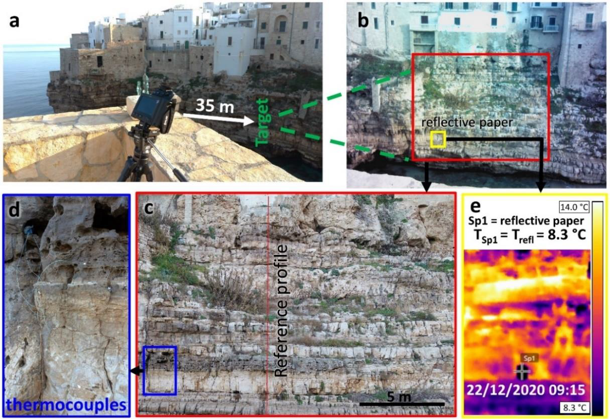
- The second analysis concerns the applicability of IRT technique for rock slope characterization. A 24- hours monitoring was carried out on the case study, and coupled with UAV systems to detect discontinuities and voids. In addition, the air-rock temperature profiles extracted from the thermograms were aligned to high-resolution photos to directly obtain information on the topography, lithology, jointing degree and Geological Strength Index of the rock mass. This section offers new insights on a technique still in development and proposes a methodology to detect some useful information (although with limitations) even if the on-site conditions are not favourable, with the possibility of using IRT techniques for the characterization of inaccessible areas.
- The last section of the second part of the thesis is devoted to the 2-D analyses of discontinuity traces from ortho-rectified photos derived from remote sensing techniques. Bi-dimensional analyses are recommended for low-relief, sub-horizontal or sub-vertical rock slope, because the extraction of discontinuities from point cloud is affected by undersampling. However, despite several advances were made for 3-D characterization from point clouds, 2-D analyses are stuck to the time-consuming methods proposed in the literature some decades ago. Recent digital implementations are not publicly available, or do not provide a comprehensive discontinuity characterization. Hence, the methods proposed in the literature were adapted to a digital environment to perform faster quantitative discontinuity characterization. To this aim, a publicly-available MATLAB routine was developed, which is able to classify the discontinuity traces into discontinuity sets and calculate their mean orientation, spacing, trace length, and persistence, as well as their probabilistic distributions. In addition, information on the fracture network is provided by means of intensity, density and trace length estimators, block volume, and block shape. The routine was built on a synthetic dataset, then applied on the discontinuity map of the case study and validated by means of conventional geostructural and geomechanical field surveys on the same area.
- In the third part of this manuscript, the overall objective of the PhD research is achieved. A
comprehensive methodology for rock mass stability assessment through the integration of remote
sensing techniques and conventional geostructural and geomechanical surveys is proposed and applied to the case study. An advanced 3-D geomechanical model was generated, based on the results
of the point clouds processing and interpretation, field surveys and laboratory tests for the physical
and mechanical characterization of the rock materials. Kinematic analyses allowed a first assessment
of the potential failures of the case study, then the typical failure mechanisms were detected by
means of field and remote sensing inspections. Later on, the geomechanical model was used to perform 3-D and 2-D numerical stability analyses. At this stage, the Finite Element Method (FEM), which is commonly used because of its versatility to model a broad range of continuous and discontinuous rock masses without assumptions on the failure mechanisms, was used to validate the developed methodology by direct comparison with the failure mechanisms observed on the field. Two different approaches were tested and compared to each other, both for the current conditions and by simulating surface processes observed in the field. This study was targeted to evaluate the effect of discontinuity implementation in FEM methods by means of a stochastic approach. However, given the complexity of the failure mechanisms of the study site, further researches are suggested as future perspective. This final part of the manuscript integrates all the investigations carried out on the study area and illustrates how different data can be combined to achieve reliable stability analyses. The importance of the input data, as well as the difficulties in producing and interpreting the results are outlined and discussed.