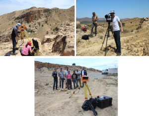
Fieldwork Campaign in Tunisia – Structural characterization of oil reservoirs with Terrestrial Laser Scanning and GigaPan technics.
As part of her PhD thesis, Raja Mastouri of the Risk Group is working on coupling terrestrial LiDAR and 3D seismic to characterize brittle structures in a sedimentary basins on Eastern Tunisia. The goal of this research is to interpret the fractures and faults systems to understand the local tectonic history and how they affect reservoir rocks. This project is done in partnership with ETAP (Entreprise Tunisienne d’Activités Pétrolières) and Prof. Samir Bouaziz at Ecole Nationale d’Ingénieurs de Sfax.
During the last week of May 2014, Raja went for fieldwork in different sites of Eastern Tunisia with Robin Marchant (curator at the Museum of Geology of Lausanne), Antoine Guerin (PhD student in the Risk Group) and engineering geologists and geophysicists from ETAP: Marzouk Lazzez, Wiem Harrathi, Achraf Boulaares and Majdi Akremi. They collected extensive information (in-situ measurements, terrestrial laser scanner and GigaPan) on fracture systems at outcrop level, with a particular focus on reservoir analogues.

