
Charlotte Wolff
Director: Prof. Dr. Michel Jaboyedoff
Jury: Dr. Marc-Henri Derron, Dr. Martina Böhme, Dr. Muriel Gasc Barbier, Dr. Ivanna Penna
Natural hazards pose significant threats to population safety, economic well-being, and natural resources. Among these hazards, gravitational instabilities (rockfalls, rock avalanches, landslides, debris flow) are particularly common and in many cases can be catastrophic in Alpine valleys. This is a challenge for the development of mountain regions, where populations and infrastructures can increase.
To minimize future losses, identifying areas at risk and evaluating the potential impacts of these events is crucial to refine hazard assessment, especially with the added uncertainties brought by global warming. Risk assessment involves identifying, analyzing, and understanding potential hazards, using dedicated instruments for data acquisition, and employing tools and methods for data processing and analysis.
The main objective of this PhD is to enhance the methodology for conducting a comprehensive hazard assessment of rock slope instabilities. A two-step workflow is effective for assessing the hazard. First, monitoring displacements and rockfall activities, combined with structural analysis of the rock mass and slope stability assessment, helps describe and justify instability characteristics and rupture scenarios (volume, surface, mechanism, susceptibility). Second, propagation scenarios of suggested volumes are developed using numerical simulations, laboratory testing, or empirical inventories of past events.
This thesis begins by presenting various instruments used for studying instabilities, such as LiDAR, InSAR, and extensometers, and the methods for assessing stability. It then introduces two toolboxes developed to help answering the research objective: one for optimizing GB-InSAR acquisition parameters, tested on two monitored cliffs, and another for describing joint networks within rock masses, tested on the Polignano a Mare cliff.
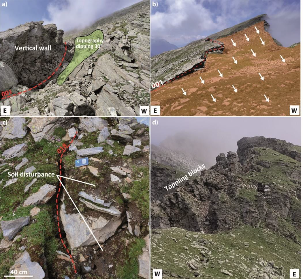
The hazard assessment workflow is applied for one specific case study; the Cima del Simano instability in the Swiss Alps, which is the core of the PhD project. This case study is motivated by a 500 m-long open fracture 100 m behind the crest, recurrent debris flow events damaging infrastructure at the slope toe, and the historical Monte Crenone rockslide in 1513, located in the vicinity caused catastrophic damages.
Eight scenarios for the volume of the instability with sizes ranging from 2.0 x 10⁵ m³ to 5.1 x 10⁷ m³ are suggested, involving different mechanisms (rockfall, deep-seated landslide, wedge sliding) are proposed, supported by monitoring, structural analysis, and numerical modeling. Monitoring highlights small movements at the summit, with rockfalls and toppling blocks detected by LiDAR and GB-InSAR. Structural analysis identifies four distinct joint families, two of which favor wedge sliding instabilities. Numerical modeling indicates significant tensile forces at the crest, explaining visible open cracks as tension cracks.
Next, the maximum run-out distance, run-up height, and lateral spreading are estimated for the rupture and propagation of the two main scenarios: S1 (4.30 x 10⁶ m³) and SS1 (2.30 x 10⁵ m³). Matching empirical and numerical results is challenging due to the presence of the opposite valley flank, but a maximum run-out distance could be estimated. Additional information on the probability of run-out exceedance and the impact distance of the rock avalanche blast could also be provided.
The study also examines weathering factors and climatic changes, such as the impact of increasing temperatures on permafrost disappearing and rock cohesion, freeze-thaw effects causing rock fatigue and propagation of joints and fractures.
Independently of Cima del Simano, attention is given to the impact of cyclic thermal variations on rock contraction and dilation, highlighted by a case study on La Cornalle cliff, which shows 24-hour cyclic rock surface movements correlated with temperature variations.
Keywords: Hazard Assessment, Rockslide, Rockfall, Debris Flow, Monitoring, Remote Sensing, Interferometric Synthetic Aperture Radar, Light Detection and Ranging, Infrared thermography, Finite Element Modeling, Kinematic Analysis, Propagation, Run-out Distance, Fahrböschung Angle, Weathering, Climate Change