Cette publication est également disponible en :
![]() Français
Français
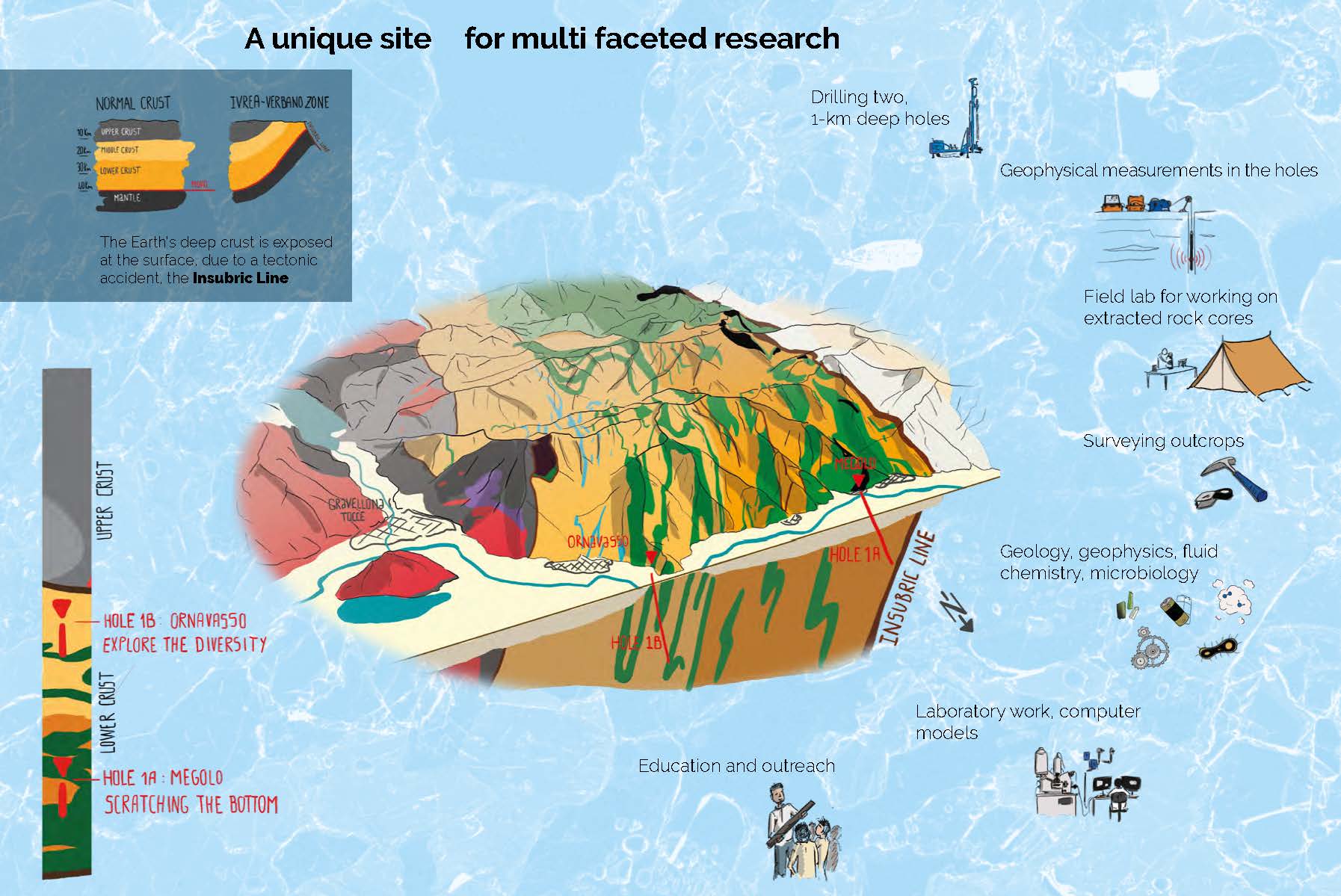
The continental crust makes up 41% of the Earth’s surface. Because of its thickness, its deepest areas remain unknown, although they play a fundamental role in the global cycles occurring between the Earth’s surface and the mantle. The DIVE project ims to unveil the secrets of these transition processes. How? Thanks to two boreholes of about 1 km deep in the region of thegeological zone known as Ivrea-Verbano (Piedmont, Italy). After five years of preparation, UNIL scientists are finally on the ground.
Reaching for the mantle: a project that is more than sixty years old
The project to reach and cross the transition from the Earth’s crust to the upper mantle dates back more than 60 years. At the time, only indirect measurements gave a glimpse of the physico-chemical properties of the rocks that compose it. But attempts to gain access to the deep crust itself, by drilling at the bottom of the ocean or in the USSR, proved unsuccessful. The technical constraints and costs generated in relation to the expected results then slowed down initiatives to renew such attempts.
What makes planet Earth unique? Together with water and life, it is plate tectonics.
DIVE project
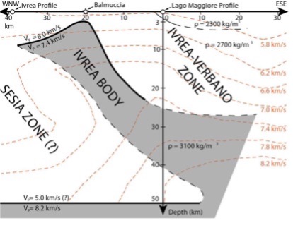
In 2008, Luigi Burlini, a geologist at the ETHZ, discussed an original idea with Othmar Müntener. It is a question of using the Alps as a “shortcut” to the mantle. In the region of Ivrea-Verbano, the Earth’s mantle is at hand: it is about 3 km deep, following the alpine folding. It was the observation of high-density rocks and the rapid movement of seismic waves that revealed this singular situation covering an area about 70 km long (known as the Ivrea Geophysical Body).
This original idea was taken up again to be concretized in 2017 during a workshop bringing together more than 45 researchers in Baveno on the shores of Lake Majeur in Italy, by setting up the DIVE project (Drilling the Ivrea-Verbano zonE). Supported by the International Continental Scientific Drilling Program (ICDP), DIVE is undertaking several scientific drillings in the Ivrea-Verbano area. His goal? Identify the physico-chemical properties of the crust-mantle transition, and better understand the processes that govern the formation and evolution of the lower continental crust.
What does the bottom of the continental crust look like? And how deep can we find life within the crust?
DIVE project
DIVE is conducted by an international and multidisciplinary research group, covering the fields of geophysics, geochemistry, geodynamics, and petrology and rheology. Microbiologists are also involved: they are trying to find out how deep life can be found in the Earth’s crust.
Other members of the FGSE (ISTE) are also involved in this project: Klaus Holliger (professor), Alexia Secrétan, Kim Lemke, Zheng Luo (PhD students), Ludovic Baron (geophysical research engineer). Aurore Toussaint, Julien Reynes and Benjamin Klein, as well as researchers from the Universities of Bern, Mainz, Trieste, Pavia, Leoben, Grenoble, Georgia, and GFZ Berlin are also part of the scientific team taking turns on the site.
This type of project cannot be done alone or in pairs, because to have all the necessary skills, as well as the associated technology, you really need this interdisciplinary collaboration.
György Hetényi
György Hetényi will focus on the transition gradient between the mantle and the lower crust: what is its thickness and what are its physical and chemical properties?
Othmar Müntener will be involved in petrological research and more specifically in the identification of the nature of the rocks that form at the interface between the mantle and the Earth’s crust.
The big day: the first drilling and extraction of the first rocks
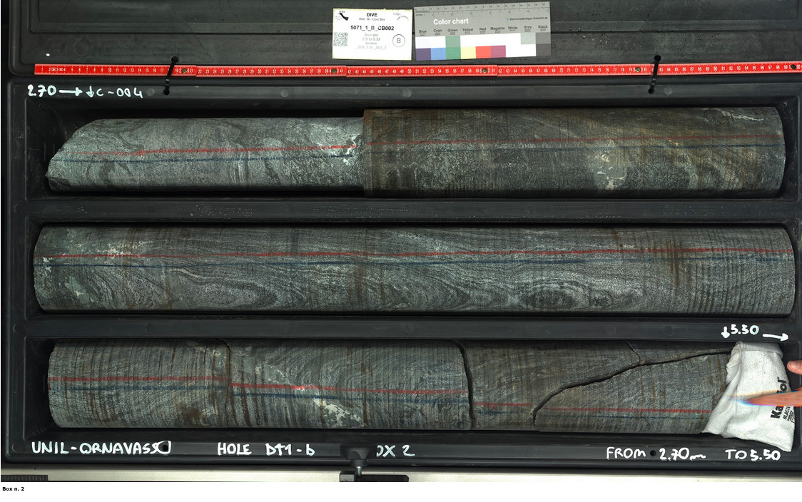
After more than five years of preparation, drilling finally began on October 6, 2022 in Ornavasso in the Osso l a. At first, the pace is slow. The team ensures the verticality of the drill and does not damage the first layers of soft soil. Subsequently, the speed should be increased to about 1 meter per hour – or 15 to 20 meters s per day ideally. So far, thefirst steps have been encouraging. The extracted carrots are exploitable at more than 95%, a very high yield!
The borehole will have another advantage. Fine logging instruments can be placed there. They will measure the electrical, thermal and seismic properties of the terrain at a depth rarely reached, and will make a video recording along the hole. This device, associated with a continuum of several hundred meters of cores through the deep crust, constitute a unique dataset to date.
The organization of this work is complex and interactions are continuous with the field. A team of 6 to 7 people remains permanently on site to monitor the drilling, analyze the extracted cores, list them on a digital interface or collect fragments for microbiologists. Questions or unforeseen events arise regularly, whether at technical level (purchase or adaptation of equipment) or scientific level (identification of minerals and structures). You have to be very responsive because drilling must be able to continue quickly.
Everyone at the drilling site was super happy…. When you see the rocks coming out, it is the direct result of these 5 years of investment. It’s really satisfying.
Othmar Müntener
A gratifying first step … who prepares the second
The results of the research carried out in the coming years on the material obtained will determine the organization and timing of the second phase of the project, namely a 3-4 km borehole in search of the Moho (the transition between the crust and the mantle).
From a scientific point of view, we are quite sure that we will have surprises either during the drilling or the analyses that will follow.
György Hetényi & Othmar Müntener
Leave a Reply