Categories
Complexity Digital twins Simulation Urban

The Rise of Digital Twins

Last March, Nature Computational Science published an issue dedicated to digital twins. From the simulators used by NASA in the Apollo missions to today’s applications in urban planning, the concept of digital twins is more alive than ever. 

Since that first application, digital twins have been nurtured by significant advances in computing power, data generation and the emergence of a wide range of methods and tools for building the ‘living models’. These developments have extended the possibilities of digital twins from industry and engineering to other fields such as social sciences, biomedicine, climate science and others, which bring their own challenges, requirements and discussions.

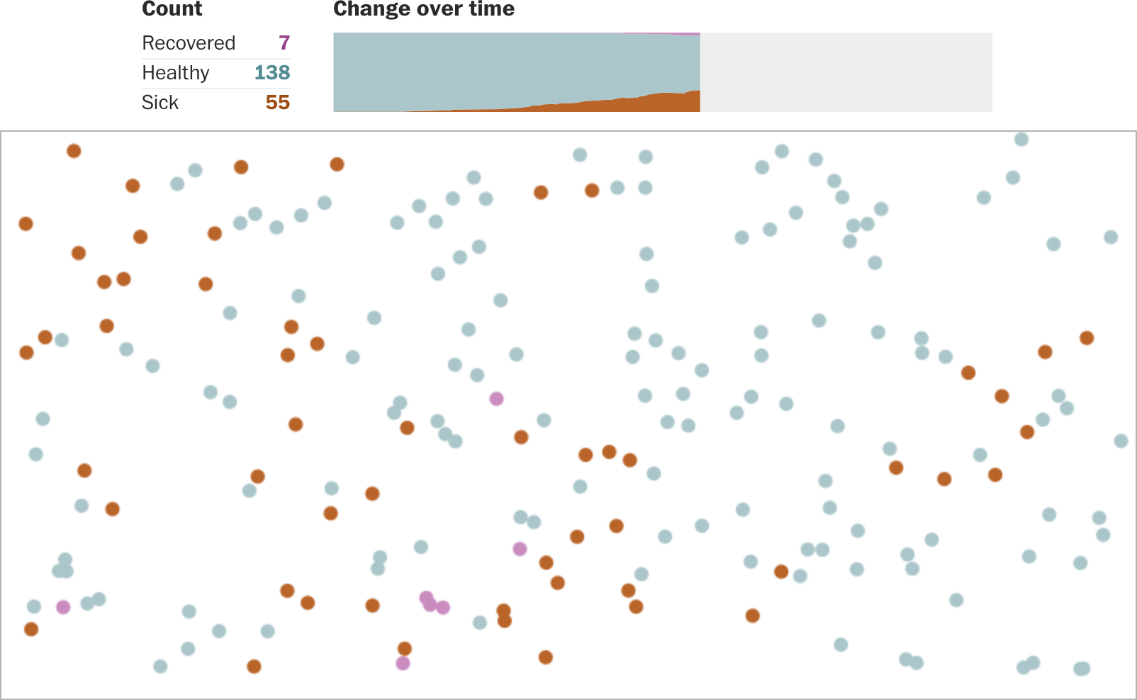
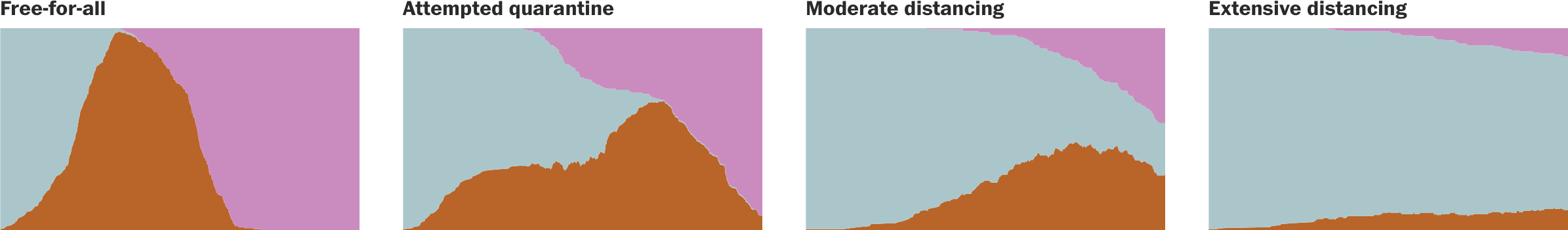
This issue of Nature Computational Science highlights the most recent developments in this flourishing field, bringing together expert point of views on the needs, gaps and opportunities for implementing digital twins in different subjects. In the context of urban planning, Michael Batty presents an article that begins with a discussion of the definition of digital twins and argues that the gap between real and digital is not the same for physical assets than for social and organizational systems. Batty claim, as well as the need to integrate humans in the loop design and use of digital twins, reminding as cities could be inherently unpredictable.

If you are interested in this issue, follow this link:

https://www.nature.com/collections/feicjiideh

Follow this link to read Michael Batty article:

https://www.nature.com/articles/s43588-024-00606-7

Source: Busakorn Pongparnit / Moment / Getty Images

Categories
Cities Complexity Economy Geography Networks Programming SCIENCE Simulation Vizualization

Cities in the face of green technologies, skills and preferences transitions – ECTQG 2023

At the European Colloquium of Theoretical and Quantitative Geography 2023 (ECTQG, 2023), Jorge Salgado – researcher at Citadyne – presented the progress of his research entitled: “Cities in the face of green technologies, skills and preferences transitions: a multilevel complex approach”. His agent-based modelling approach allows the simulation of changes in firms technologies and consumer preferences as a result of the green transition. The research has been well received because it simultaneously integrates key elements of the economic system, enabling bottom-up interactions to understand the reconfiguration of urban systems around the world.

If you are interested in this research you can contact Jorge Salgado: 

jorge.salgado@unil.ch

Categories
Cities Programming SCIENCE Simulation Urban Vizualization

A model-based spatio-temporal classification of global urban expansion  – ECTQG 2023

Dr Jingyan Yu, – postdoctoral researcher and member of Citadyne – presented the first results of her research “A model-based spatio-temporal classification of global urban” at the European Colloquium of Theoretical and Quantitative Geography 2023 (ECTQG, 2023).  She has developed static and dynamic measures to simulate urban expansion in Functional Urban Areas (FUA) around the world. She has found a global trend of physical spatial dispersion, producing discontinuous, dispersed built-up areas.

If you are interested in this research you can contact Dr Yu:

jingyan.yu@unil.ch

Categories
Books Cities Complexity Local digital twin Metaverse Simulation

Smart Metaverse City – Digital twins cities

Smart Metaverse City – Digital twins cities

According to Charitonidou (2022), digital twins are virtual replicas of cities that are used to simulate environments and develop scenarios to address policy issues related to urban planning (e.g., sustainability, climate change, transport, etc.). Recently, Xu et al. (2023) published the chapter “Toward a Smart Metaverse City: Immersive Realism and 3D Visualization of Digital Twin Cities” in “Advances in Scalable and Intelligent Geospatial Analytics” (Durbha et al., 2023). The publication presents a conceptual prototype that combines the unique advantage of metaverse technology with the two-way connectivity of a digital twin city application.

This combination offers the possibility to create a virtual environment for immersive geovisualization that provides the opportunity to understand the complex urban system through science-based and data-driven approaches. The proposal and its real-world applications are discussed based on a twin city developed at Oak Ridge National Laboratory to facilitate participatory, smart and sustainable campus management.

More about this publication could be find in the following link:

https://shorturl.at/bxCDX

If you are interested in the Oak Ridge National Laboratory initiatives, you could follow this link: 

https://www.ornl.gov/

Image:World Economic Forum

References:

Charitonidou M.  (2022). Urban scale digital twins in data-driven society: Challenging digital universalism in urban planning decision-making. International Journal of Architectural Computing. 2022;20(2):238-253. doi:10.1177/14780771211070005

Durbha, S.S., Sanyal, J., Yang, L., S Chaudhari, S., Bhangale, U., Bharambe, U., & Kurte, K. (Eds.). (2023). Advances in Scalable and Intelligent Geospatial Analytics: Challenges and Applications (1st ed.). CRC Press. https://doi.org/10.1201/9781003270928

Categories
Geography Programming Simulation

How to use ChatGPT in your daily GIS work

ChatGTP was launched by OpenAI last November. Since then, it has been widely recognized as a game-changing tool for research and everyday life. In this article by Dymaptic, 6 Ways to Use ChatGPT in Your Everyday GIS Work, you can find out how the most famous chatbot could be integrated into your daily use of GIS. Among the most relevant, ChatGPT could help you decide which tool to use. It is also capable of comparing GIS applications, writing basic code, and explaining what GIS is to a non-specialist.

https://blog.dymaptic.com/6-ways-to-use-chatgpt-in-your-everyday-gis-work

Categories
Geography Mobility Networks SCIENCE Simulation Social network

Google mobility reports: big data to help fight Covid pandemic

Last week Google has published the “COVID-19 Community Mobility report”. In the context of strict confinement measures, and while some governments (China above all but also Italy, France and Spain) have resorted to mobile phone data to assess whether citizens are respecting the lockdown, Google has published anonymized mobility data from a number of countries showing the effect of limitations on individual movements.

The reports use aggregated, anonymized data to chart movement trends over time by geography, across different high-level categories of places such as retail and recreation, groceries and pharmacies, parks, transit stations, workplaces, and residential. We’ll show trends over several weeks, with the most recent information representing 48-to-72 hours prior. While Google displays a percentage point increase or decrease in visits, they do not share the absolute number of visits. To protect people’s privacy, no personally identifiable information, like an individual’s location, contacts or movement, is made available at any point.

In Switzerland, for example, data are available on a national and canton basis, and they show a clear decrease in mobility patterns since the beginning of the lockdown on March 16.

What about your country or local area?

You can access all reports at https://www.google.com/covid19/mobility/


Categories
Graph analysis Networks SCIENCE Simulation

The cosmic web and a slime mold: network patterns across scales

Is there a relation between a yellow slime organism called Physarum polycephalum, that  can be easily found on decaying trees and leaves in the forest’s shade, and the complex organization of galaxies?

Researchers Joe Burchett and Oskar Elek at the University of California at Santa Cruz created a 3D algorithm that represents how the slime builds its networked structures in space. Then, they applied the algorithm to a dataset of 37.000 galaxies, finding a rather precise representation of the cosmic web. In the words of one of the authors:

“That was kind of a Eureka moment, and I became convinced that the slime mold model was the way forward for us,” Burchett said. “It’s somewhat coincidental that it works, but not entirely. A slime mold creates an optimized transport network, finding the most efficient pathways to connect food sources. In the cosmic web, the growth of structure produces networks that are also, in a sense, optimal. The underlying processes are different, but they produce mathematical structures that are analogous.”

This is an interesting step towards understanding the laws of complexity and how they create similar structures across scales. Read the full contribution here.

Categories
Geography Simulation Social network Vizualization

An agent-based simulation of coronavirus diffusion

As the coronavirus pandemic continues to spread across the world, governments are taking measures to slow down the spread of the contagion among the population. In fact, while there is no way the virus can be stopped altogether, it is crucial to slow down its diffusion in order no to overload hospitals and intensive care units.

Journalists of the Washington post have created an agent based simulation  in order to explain the importance of social containment measures in which agents, represented as moving dots, move into space getting infected, transmitting the disease and recovering. The four different simulation scenarios  — a free-for-all, an attempted quarantine, moderate social distancing and extensive social distancing — show that when restrictions to the movement are implemented the contagion curve clearly flattens out, while if the agents are left unrestrained the curve of infected people grows exponentially.

This timely piece of data journalism shows the importance of social distancing during this unprecedented global pandemic and interest and the potential of agent-based models to illustrate social dynamics in space.


Categories
Cities Geography Networks Simulation World

Can cities’ network position explain the probability of violent conflict?

When we consider the global network of cities, is instability an inherent property of certain network positions?

Dr. Weisi Guo from Cardiff University believes this is the case. He recently co-authored a study in which he found that cities with a high network betweenness – that are centrally located in a path that connects different cities in the network-  are more likely to display high levels of violence, including war, terrorism and gang violence. On the other hand, cities with a high degree  or having connections to many other cities – were found to display a low level of violence.

How to interpret these results? the authors develop an agent based model that suggests that cities with fuzzy cultural boundaries, that serve as connections between culturally homogeneous areas, are indeed those with a higher level of betweenness. On the contrary, cities that are more culturally homogeneous turned out to show also a higher degree.

Even if the authors warn against the attempt to establish causality, which cannot be assessed by the study, their methods accurately identify some of the world’s current foci of conflicts such as Damascus, Aleppo and Baghdad but also Veracruz and Tegucigalpa, in central America. Also, the authors identify a number of cities that do not show at present a high level of violence but which might in the future such as La Mecca and Jeddah in Saudi Arabia, Teheran or Kunming in China.

Their study has been extensively covered by BBC   here

Also, you can access the full study, titled “The Spatial Ecology of War and Peace”  here. 

If you want to know more about the authors, they are:


Categories
Geography Simulation

International Land Use Symposium (ILUS) 2017 – Use of spatial modelling and data visualisation to enlighten future sustainable policy making

Date: November 1-3 2017

Steigenberger Hotel de Saxe, Dresden, Germany

Call for Abstracts (Deadline: 31 July 2017)
Suggested topics for English-language presentations can be submitted via the symposium website (https://www.ilus2017.ioer.info).

Main Topics:
– Big Data and the City as a Complex System
– Historic Settlement and Landscape Analysis
– Morphological Analysis
– Varia: This topic contains free contributions whose topical focus is indirectly related.

Registration (Deadline for early bird registration: 31.08.2017)
Also the registration for participants without own contribution is possible from now on:

https://www.ilus2017.ioer.info/registration.html

Further Information
https://www.ilus2017.ioer.info

Categories
Cities Misc Networks Research project Simulation Social network Social science

Theories and models of urbanization

ERC GeoDiverCity International Workshop

Thursday 12th and Friday 13th October 2017 | Paris, France


ERC GeoDiverCity

https://geodivercity.parisgeo.cnrs.fr/blog/international-workshop/

Categories
Cities Economy Misc Networks Research project SCIENCE Simulation Social network Social science Society Vizualization

CCS’15 & CS-DC’15 – Watching again the E-Session on Territorial Intelligence for Multi-level Equity and Sustainability

cropped-cropped-logo2

For those who missed the session Territorial Intelligence for Multi-level Equity and Sustainability, you can visualize online individually each presentation :

Denise Pumain, University Paris 1. ERC GeodiverCity (Keynote Speaker – Conference CS-DC)

World Urban Dynamics and climate change toward territorial intelligence for ensuring sustainability and equity by multi-level governance

Panos Argyrakis, University of Thessaloniki

Comparison of single and multiplex patent networks

Celine Rozenblat, Antoine Bellwald, University of Lausanne

Self reinforcement between urban firm’s networks at local and global scale: Comparison of single and multiplex patent networks

Elfie Swerts, ERC GeodiverCity

Scaling laws in Chinese urban system in light of harmonized data

Olivier Finance, University Paris 1 – CNRS

Scaling laws to explore innovative behavior of transnational investment

Paul Chapron, ERC GeodiverCity

Building and exploring systems of cities models via high performance computing

Denise Pumain, University Paris 1. ERC GeodiverCity

Scaling laws in urban evolution: A construction in territorial intelligence


The entire program of the TRACK “From Fields to territories to the Planet” is available here:

https://cs-dc-15.org/e-tracks/territories/

Categories
Cities Europe Geography Graph analysis History MAPS Networks Simulation Vizualization

ORBIS: the Stanford Geospatial Network Model of the Roman World

The system calculates the distance from a city to another one, according to faster path, or lower cost.

https://orbis.stanford.edu/

Go to “Mapping ORBIS”, It draws the path and create many different maps and graphs (in “Map gallery”). It’s a pity that the Emperors did not have this system 🙂


Categories
Art Economy Environment SCIENCE Simulation Society Vizualization World

Tomorrow’s world

A guide to the next 150 years

 by BBC news graphics

https://www.bbc.com/future/story/20130102-tomorrows-world

Categories
Cities Communication Economy Environment Geography Graph analysis MAPS Networks SCIENCE Simulation Social network Society Vizualization World

When Networks Network

The magazine Science underline the huge advance made in network analysis. Networks interact, create cascading effects……

read more in Science

Categories
Cities Geography Graph analysis Research project Simulation Social network Society Vizualization World

New Blog for the ERC project GeoDiverCity

https://geodivercity.parisgeo.cnrs.fr/blog/

Categories
MAPS Simulation Society Vizualization World

Interactive maps of the world population on the INED website

a terrific tool to give to students, children, citizens of the world….

https://www.ined.fr/en/everything_about_population/interactive_maps/

See the instructions:

publi_pdf2_pesa485