Original text published on https://wp.unil.ch/geoblog/2024/03/des-sites-web-a-la-perception-de-la-sante-publique-dans-diverses-regions-du-monde/
Drawing on millions of texts from websites and official publications, Céline Rozenblat and her team used artificial intelligence techniques to explore how health and sustainable development issues are addressed across the globe. Conducted in collaboration with the WHO, this research reveals regional disparities in how urban health is integrated into public policy. Far from being a magical solution, AI is used here as a diagnostic tool—complementary to explanatory approaches—to better understand complex urban systems and support the most vulnerable regions.
Céline Rozenblat used AI for the first time in a project carried out in collaboration with the World Health Organization. The aim of this study was to identify which public or private actions addressed—or failed to address—urban health challenges across different regions of the world, and to examine how these challenges and actions were, or were not, connected to issues of sustainable development.
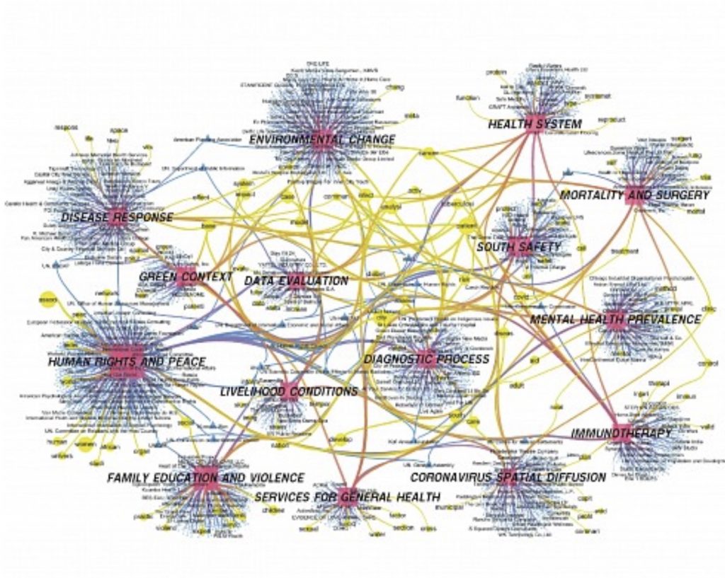
Millions of publications and institutional websites were analyzed in order to extract their content and classify co-occurring terms. Instead of applying a standard classification, the researchers used topic modeling to identify meaningful word associations. One of the findings shows that actions tend to be more compartmentalized—health issues remaining largely distinct from sustainability issues—in regions where institutions have a long-standing presence, such as Europe and North America. According to Céline Rozenblat, ‘The results of this approach highlighted clearer, more streamlined (with fewer parameters), and more robust relationships than those obtained with standard classification models.’
Cities change shape or grow – but why?
Currently, Jingyan Yu, a postdoctoral researcher in Céline Rozenblat’s group, is studying the evolution of urban sprawl worldwide over time. Initially focused solely on the analysis of satellite images (pixel content differences—urban versus non-urban), her models now incorporate AI to qualify the observed changes and are progressively integrating models of urban functioning, in order to understand which parameters most strongly influence the growth or transformation of city forms.
Combine black box and white box to be able to work in a grey area
Currently, Jingyan Yu, a postdoctoral researcher in Céline Rozenblat’s group, is studying the evolution of urban sprawl worldwide over time. Initially focused solely on the analysis of satellite images (pixel content differences—urban versus non-urban), her models now incorporate AI to qualify the observed changes and are progressively integrating models of urban functioning, in order to understand which parameters most strongly influence the growth or transformation of city forms.
MOOC Healthy urban Systems
According to Céline Rozenblat, the impact of AI depends on how it is used. It can be applied like following a recipe, which does not generate new knowledge, or it can be leveraged to go beyond established principles. She specifically refers to the approach of deriving equations from the analysis of thousands of data points—a process known as ‘machine scientists.’ Here, the goal is to let AI test numerous equations within the data and extract the most suitable ones, i.e., those that best capture the relationships among the variables. AI is essential in this context, as it can combine thousands of types of equations that would be impossible to test with standard models. Researchers can then select the equation most consistent with a theoretical framework or compare different equations to foster fruitful debates. Céline Rozenblat describes this process in a MOOC on the systemic approach to urban health (Healthy Urban Systems), which includes several chapters dedicated to AI.
One of the promising uses of AI, according to her, lies in its potential role in supporting developing regions. For example, the enhanced and systematized analysis of satellite imagery through AI can assist in land management in areas where resources for field measurements or data exchange are limited.
Professor Céline Rozenblat, a geographer and specialist in complex systems, mainly studies cities and the various networks that support their functioning.
Faculty of Geosciences and Environment
Geo-AI, Information management, Urban Digital Twins, Modelling
