Original text published on https://wp.unil.ch/geoblog/2024/03/modelisation-geostatistique-du-sous-sol/
Faced with the complexity of the subsurface and the scarcity of available data, Niklas Linde, a geophysicist at UNIL, turned to artificial intelligence to enhance geostatistical modeling. By using deep generative models—similar to those capable of producing realistic faces or landscapes—his team has succeeded in replicating aquifer structures with unprecedented accuracy. Once skeptical, Linde is now considered one of the pioneers of machine learning in geosciences. Their approach, initially misunderstood, is now widely recognized, highlighting AI’s transformative potential for deepening our understanding of the planet—literally and figuratively.
Teaching AI to recognise and generate geological structures
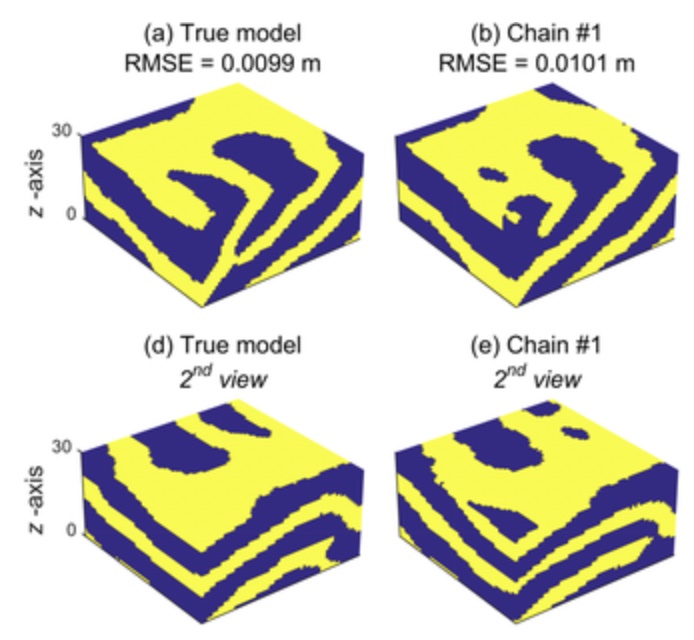
Applications of this method to aquifer modeling—geological structures that hold water either permanently or temporarily—have yielded results superior to those produced by more conventional techniques. Niklas Linde explains: “The probabilistic values generated by these models make the results potentially more actionable for field users—for example, they allow us to estimate the likelihood that a given subsurface area contains specific geophysical properties.” The next objective is to improve the algorithms to reduce training time and further enhance model accuracy.
The original idea, proposed by his colleague Eric Laloy, was to use deep generative model algorithms—similar to those used in applications that create new faces from millions of facial images—to generate new geological images that share characteristics with existing ones (training images). In the research led by Niklas Linde and his collaborators, these training images consist, for example, of rock outcrops, which provide valuable insights into the nature of the surrounding subsurface. The algorithms were trained on a large number of such images to learn how to represent these geological structures and their properties.
Sceptical at first
Niklas Linde states, “Before this research, I didn’t think machine learning could be very useful in geophysics.” He initially considered models based on physical principles and data to be sufficiently accurate and preferable to purely data-driven approaches. Faced with increasingly complex subsurface models, he became one of the early adopters of deep learning in the field (see box). The growing use of AI in geosciences—and the progress that followed—demonstrates that the cost of integrating machine learning into complex models is more than offset by its advantages, particularly in representing intricate relationships and testing large numbers of model variations.
A pioneering role
Niklas Linde and his colleagues were among the pioneers in applying deep learning to geosciences, using inverse modeling to generate geologically realistic subsurface models that align with geophysical data. When they submitted their first paper describing this approach in 2017, the editor rejected it, deeming the method irrelevant. The article was eventually accepted by another journal. Their second paper on the topic also faced initial rejection before being accepted in 2018 after resubmission. Today, publications on the use of deep learning in geosciences are abundant.
Professor and geophysicist Niklas Linde has a particular interest in environmental processes related to hydrogeology.
Faculty of Geosciences and Environment
Machine learning, Geostatistics, Aquifers