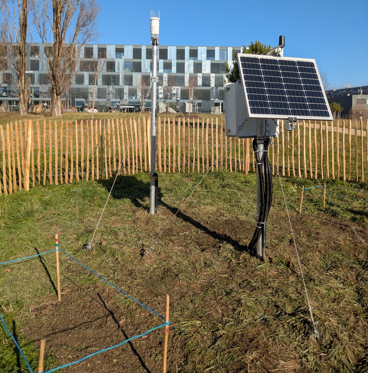
The UNIL meteorological station is an experimental scientific facility located on the UNIL campus in the Mouline district. It records meteorological and soil data and transmits them in real time to a server so that it is available to the wider community.
Where is it ?
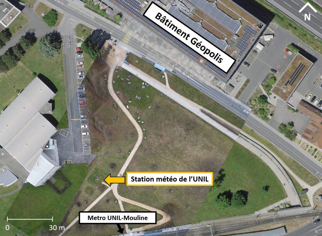
The station is situated at an altitude of 400 metres in the municipality of Lausanne, between the UNIL-Mouline metro station and the Géopolis building, at the following coordinates :
CH1903+/LV95 : 2534038.00, 1153039.04
WGS84 : 46.52538878, 6.57895419
What is it used for ?

High-frequency data measured by a meteorological station can be used for scientific studies :
- Hydrological monitoring (precipitation and evaporation conditions in a catchment area)
- Environmental monitoring (biological activity, ecosystem dynamics)
- Weather monitoring (seasonal trends, extreme events)
and for various applications :
- Crop management (adapting to their water and heat requirements)
- Risk management (fire, flooding, drought)
- Building management (heating, air conditioning)
- Renewable energy production (wind and sunshine levels)
Sensors located at different depths measure water storage in the soil, thereby enabling the determination of water flow paths and the recharge capacity of groundwater aquifers. This data is used in pedology, the science of soils, as well as in agronomy to determine the water stress conditions affecting vegetation. It thus enables plantations to be adapted to suit soil moisture conditions and allows for the management of their irrigation.
The various parameters measured at the UNIL station are:
Weather parameters
- Precipitation refers to the quantity of water, in liquid or solid form, that falls from the atmosphere. It is measured in terms of water depth in mm (millimetres), which enables us to determine rainfall patterns – that is, its spatial distribution – which, together with temperature, shapes the climate and, consequently, the functioning of ecosystems. In hydrology, precipitation corresponds to the amount of water entering a catchment area. This water may then infiltrate the soil and recharge groundwater, run off and feed watercourses, or be taken up by plants.
- Air temperature, measured in °C (degrees Celsius), together with precipitation, governs terrestrial climates and the biological activity of ecosystems. Air temperature, together with atmospheric pressure, also determines the state of water: gaseous, liquid or solid.
- Relative humidity, expressed as a percentage, corresponds to the amount of water in gaseous form present in the atmosphere relative to the air’s capacity to hold water vapour at a given temperature. If relative humidity reaches 100 per cent, the air is saturated with water vapour, which then condenses to form clouds.
- Atmospheric pressure, is the weight of the column of air above the Earth’s surface. It depends on altitude and air temperature. It is measured in mbar (millibars) and helps assess weather conditions: high atmospheric pressure is generally associated with sunny weather, while low pressure indicates cloudy conditions. Differences in atmospheric pressure also drive air movements, thereby determining the direction and speed of the wind.
- Saturation vapour pressure, measured in mbar (millibars), is the maximum amount of vapour that air can hold at a given temperature. It increases as the temperature rises. If the partial vapour pressure exceeds the saturation vapour pressure, condensation occurs.
- Wind is the movement of air masses. Its speed is measured in m/s (metres per second) and its direction in ° (degrees). Three main winds blow in the Lake Geneva region: the Vent (from the south-west), the Bise (from the north-east) and the Foehn (from the south-east).
- Solar radiation, measured in W/m² (watts per square metre), comprises all the electromagnetic waves emitted by the sun. When it reaches the Earth’s surface, depending on the albedo of the surface it strikes, a greater or lesser proportion is reflected. The remainder of this radiation is absorbed by the Earth’s surface in the form of heat or by plants as a source of energy during photosynthesis.
- Measuring the number of lightning strikes and the distance of the lightning strikes enables warnings to be issued where necessary to protect property or people.
Soil parameters
- Soil temperature, measured in °C (degrees Celsius), influences the chemical, biological and physical processes taking place within the soil. Indeed, many chemical reactions occur more rapidly when the soil temperature is higher. Furthermore, soil temperature influences plant growth, as each plant has its own optimum growth temperature. Soil activity also depends on its temperature, with microorganisms generally being more active at higher temperatures. Finally, this biological activity affects soil structure and, consequently, its physical properties.
- Soil moisture refers to the amount of water stored within the soil. It depends on meteorological factors (precipitation, evaporation, temperature, radiation, wind) and soil-related factors (porosity, particle size, organic matter content, aspect, slope). It enables the determination of the two thresholds between which water is available to plants: the wilting point and field capacity.
- As water moves from a point of high energy to a point of lower energy, measuring water potential – usually in kPa (kilopascals) – helps to explain the movement of water through the soil and plants. Water potential is used, for example, in agriculture to optimise irrigation by assessing the availability of water in the soil for plants.
Who benefits from it ?
- The UNIL Hydrology Research Group uses this data in its hydrological model of the Chamberonne catchment area.
- UNIL’s Buildings and Works Department (UNIBAT) may it to manage the campus’s green spaces, including for watering.
- The data can be used in teaching, to explain certain weather phenomena or to develop exercises specific to the campus.
- The presence of the station can also benefit science outreach by incorporating it, for example, into science trails on campus.
- The data can be used to validate forecasts from certain MeteoSwiss models and can be incorporated into cantonal databases.
- The data is available to everyone, so all members of the UNIL community, as well as local residents, can make use of it.
How does it work ?
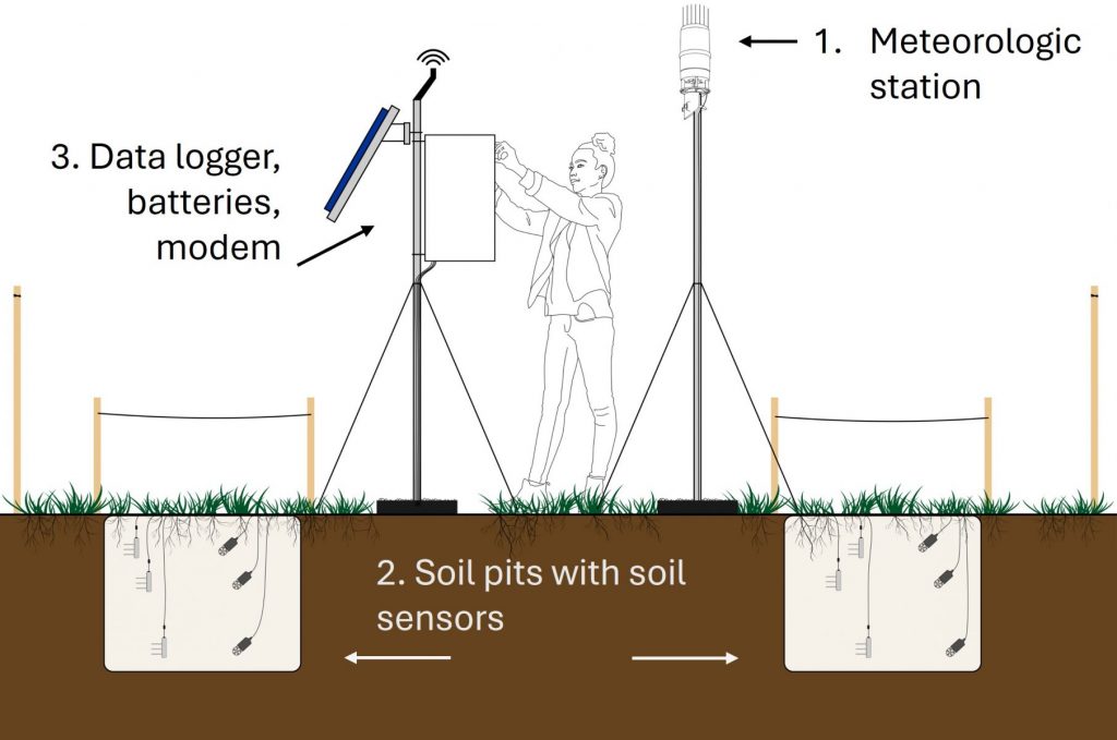
The station comprises:
- A mast fitted with a Campbell ClimaVUE 50 G2 compact weather station
- Two pits in the ground housing a network of METER TEROS 11 and TEROS 21 sensors
- A mast on which a solar panel, a data logger and a remote communication antenna are installed
The station’s sensors are:
Weather sensors
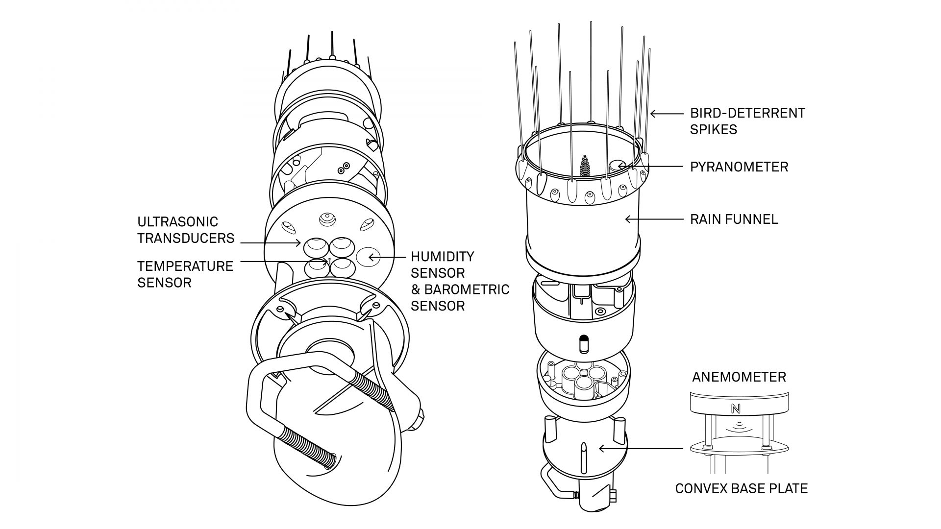
- Rain gauge. Precipitation is measured in two ways: by counting the number of drops in a calibrated volume, and by means of a tipping bucket that tips over each time the mass threshold is reached.
- Thermometer. The air temperature is measured by a thermistor situated amongst the ultrasonic sensors. Its electrical resistance varies with temperature.
- Wind speed is measured by an ultrasonic anemometer located beneath the rain gauge. Ultrasonic waves are emitted towards the convex base plate (see image below) and are reflected back to the sensors. The speed of sound through this space is affected by the wind. The wind speed is then calculated by measuring the difference in the time taken for the sound to travel between the sensors and back. The advantage of this type of anemometer, compared to the more common cup anemometer, is that it requires less maintenance.
- Hygrometer. The sensor measures the relative humidity and air temperature within a chamber protected from liquid water. The vapour pressure is then calculated using these two measurements. Since vapour pressure does not vary with temperature but relative humidity does, the true relative humidity is calculated using the true air temperature and the calculated vapour pressure.
- Barometer. Barometric pressure is measured by a sensor located in the same chamber as the hygrometer. It is relative to the station’s altitude (i.e. 400 m above sea level) and is not corrected for altitude.
- A silicon-cell pyranometer integrated into the rim of the rain gauge’s funnel measures total solar radiation (direct and diffuse).
- The lightning counter uses an amplitude-modulated (AM) radio signal. When lightning strikes, an electromagnetic wave is emitted which disrupts the AM radio signal. The time of the pulse is recorded, along with the distance of the lightning strike, calculated based on the amplitude of the signal.
Soil sensors
- The TEROS 11 soil moisture sensors generate an electromagnetic field to measure the dielectric permittivity of the medium under investigation. To do this, the sensor sends a 70 MHz oscillating wave to the sensor probes. Their charging time is then proportional to the permittivity of the substrate and therefore to its water content.
- Measuring water potential using TEROS 21 tensiometers involves introducing a material of known particle size into the soil until it reaches thermodynamic equilibrium with the soil water. Measuring the water potential of the material then provides the water potential of the soil. The water potential of the material is derived from the measurement of its water content, plotted on its water retention curve.
From campus to your phone
The physical station is only one part of the whole monitoring system. Before measurements can be viewed by users, they pass through several stages.
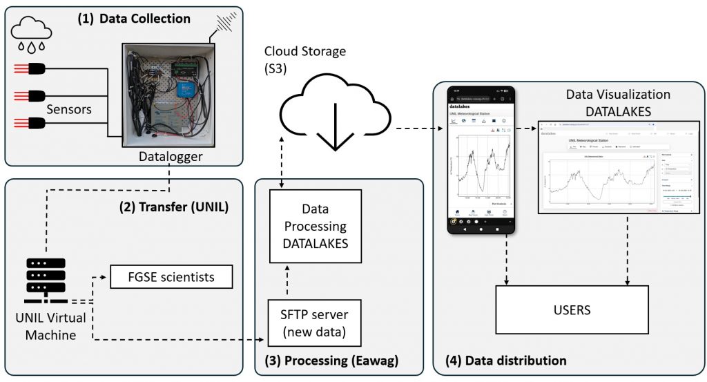
- Data collection. Sensors in the field collect information and send it to a data logger located inside the white box.
- Transmission. Every five minutes, the data logger sends the new measurements to a Unil server via a modem located inside the white box. This is the most energy-demanding part of the system and is powered by a solar panel.
- Processing and storage. The data is automatically sent to a server at EAWAG, where it is checked, formatted, and stored in the cloud.
- Access. The DATALAKES platform retrieves the data from the cloud and makes it available on computers and smartphones. Users can view the data just a few minutes since collection in the field, and download it for further analysis.