
Current projects
Crop Wild Relatives (CWRs), i.e. the COUSINs of domesticated crops, represent a natural source of genetic variation. The COUSIN consortium recognizes the value of CWRs for agriculture, but also the challenges of their utilisation. We will demonstrate a roadmap for the use of CWRs in breeding and farming. We will work with five flagship crops: wheat, barley, pea, lettuce and brassicas. With these exemplary crops, we demonstrate how current challenges of stakeholders from farm to fork can be overcome using CWRs in formalised and participatory breeding.
WP2 – Monitoring and conservation of Crop Wild Relatives
The main objectives of WP2 are to provide knowledge and document the state of CWR diversity across the environmental and geographical gradients in Europe. This, in turn will improve the conservation of the CWR populations across the whole European region. In particular, data concerning a selected list of CWR of proven importance in major crops for human food, forage and fodder, including the CWR of the five flagship species of COUSIN will be generated and feed into various conservation measures.
Based on the current state of knowledge and using state-of-the-art species modelling, this WP will focus on 4 main objectives:
- Evaluating the extent of the diversity of species, traits and phylogeny for relevant CWR taxa (identified by prioritizing their relationship to a crop, including COUSIN flagship crops, and their conservation status) with a particular focus on agricultural land, protected areas, and habitat types hosting particularly valuable CWRs.
- Promote the establishment of genetic reserves by: (1) identifying relevant areas in terms of diversity, and resilience to climate change and other threats to be integrated into in situ CWR conservation strategies; (2) preparing guidelines for the set-up of genetic reserves for in situ conservation. (3) Establish at least 3 pilot genetic reserves representing the range of different environments and management regimes across Europe. And to start a database at European level that collects the data of all CWR reserves in order to be a source of consultation for their use in breeding.
- Identify relevant priority CWR taxa and populations to be conserved in ex situ collections. Organize seed collecting expeditions to provide the corresponding germplasm to local genebanks.
- Improve coordination between in and ex situ conservation (trans situ) in order to maximise conservation and sustainable use of the CWR gene pools.
Collaborators:
Luca Bütikofer (Unil), Blaise Petitpierre (Infoflora), Sylvain Aubry (OFAG),
Olivier Broennimann (Unil), Antoine Guisan (Unil)
External links
-
Official website of the COUSIN project
-
Participatory Call for ex-situ collection of Crop Wild Relatives
Glacial habitats host an astonishing diversity of species and life forms; however, most of the world’s mountain glaciers are melting due to climate change, threatening glacier biodiversity and the functioning of mountain ecosystems. In Europe, glacier retreat is particularly severe for the southernmost, peripheral mountain chains, where the smallest glaciers occur. The European Habitat Directive includes ‘Permanent Glaciers’ in the list of habitats deserving conservation, and glacial habitats host several endemic species. Nevertheless, none of these species is listed in the Habitat Directive, and information on biodiversity of these environments is scarce, hindering our ability to manage mountain socio-ecological systems.
External link: https://www.biodiversa.eu/2023/04/19/prioritice/
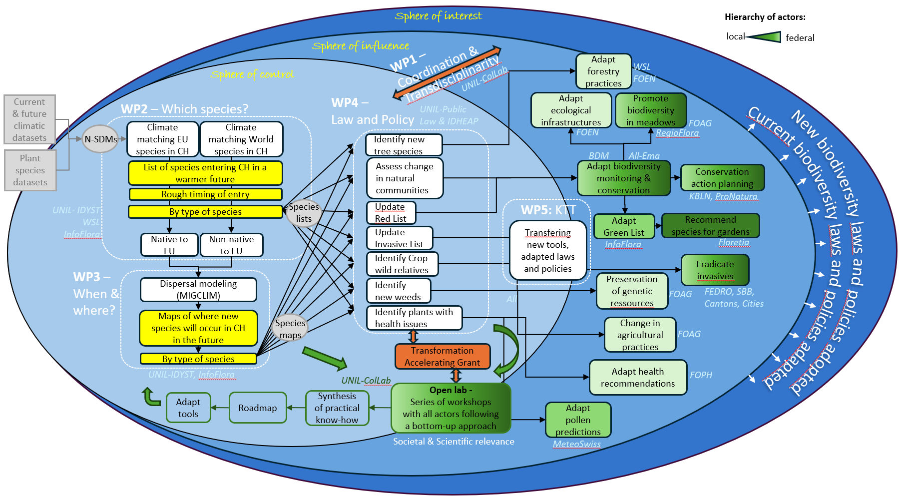
FutureSpeciesCH explores which native and non-native species could establish in Switzerland as the climate warms, and what their arrival could mean for biodiversity, agriculture and forestry.
Climate change is shifting suitable habitats northwards and towards higher elevations, creating opportunities for species not currently found in Switzerland—the emerging group of “neo-native” species. Some may enrich ecosystems, others could disrupt them, while still others may have little impact. Yet current Swiss biodiversity policies and legislation do not provide a framework to anticipate or manage these future arrivals. FutureSpeciesCH addresses this gap by combining ecology, species distribution modelling, law and policy to forecast which species could reach Switzerland, where and when they may establish, and what consequences they could have. The project will develop newcomer species lists for 2035 and 2060 under future climate scenarios, identify likely entry points and patterns of spread, and assess their relevance for biodiversity, agriculture and forestry. Through an Open Lab, researchers will work closely with stakeholders at federal, cantonal and communal levels to evaluate the legal, policy and management implications. The project will provide practical knowledge and policy tools to help Switzerland anticipate future biodiversity changes and develop effective strategies for managing species in a rapidly changing climate.
Project Leaders
- Prof. Antoine Guisan, FGSE & FBM, University of Lausanne
- Prof. Thierry Largey, FDCA, University of Lausanne
- Prof. Stéphane Nahrath, FDCA, University of Lausanne
- Dr. Blaise Petitpierre, InfoFlora, the National Data and Information Center on the Swiss Flora
Project Partners
- Dr. Olivier Broennimann, FGSE & FBM, University of Lausanne
- Dr. Alexandre Camus, Head of Citizen Science Unit, Research Office, University of Lausanne
- Prof. Stéphane Nahrath, FDCA, University of Lausanne
- Alain Kaufmann, Research Associate, LIVES center, University of Lausanne
- Prof. Niklaus Zimmermann, Swiss Federal Research Institute WSL
- Dr. Gian-Reto Walther, Federal Office for the Environment (FOEN)
- Dr. Christina Kägi, Federal Office for Agriculture (FOAG)
- Prof. Wilfried Thuiller, University Grenoble-Alpes, France
Project collaborators
- Maeva Früh, PhD student, FDCA, University of Lausanne
- Arthur Provost, PhD student, FGSE, University of Lausanne
External link: NRP82 website
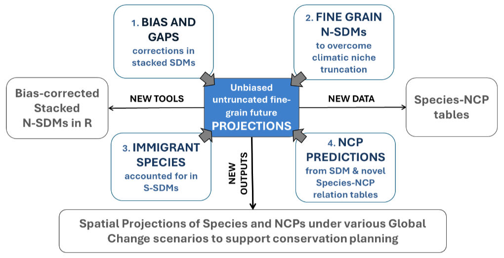
PROMOUNT aims to improve our ability to understand and predict how mountain biodiversity and nature’s contributions to people will change under global environmental change.
Mountains harbour exceptional biodiversity and provide essential benefits to society, yet climate change, land-use change, biological invasions and other pressures are rapidly transforming these ecosystems. PROMOUNT will develop new approaches to overcome major challenges in predicting these changes, including gaps and biases in biodiversity data, limitations caused by restricted modelling areas, and the arrival of new species into mountain regions. The project will combine biodiversity observations with environmental data and advanced spatially nested species distribution models to produce robust, fine-resolution projections of species and communities across the Swiss and European Alps, and potentially other mountain ranges worldwide. By accounting for species currently absent from a region but likely to colonise it in the future, the project will provide more realistic assessments of biodiversity turnover under climate change. PROMOUNT will also link species distributions to their contributions to people, such as ecosystem services and other benefits provided by nature, by developing comprehensive species–nature contribution relationships. These projections will be used to identify how biodiversity and nature contributions may change in the future, detect important gaps in biodiversity knowledge, and support spatial conservation planning. The project will ultimately deliver new data, modelling tools and practical approaches to help anticipate and manage biodiversity change in mountain regions.
Project Leader
- Prof. Antoine Guisan, FGSE & FBM, University of Lausanne
Project Collaborators
- Erwan Bellon, FBM, University of Lausanne
- Dr. Olivier Broennimann, FGSE & FBM, University of Lausanne
- Dr. Davnah Urbach, Global Mountain Biodiversity Assessment (GMBA), University of Lausanne & Bern
- Mark Snethlage, Global Mountain Biodiversity Assessment (GMBA), University of Lausanne & Bern
Project Partners
- Prof. Wilfried Thuiller, University Grenoble-Alpes, France
- Prof. Niklaus E. Zimmermann, Swiss Federal Institute WSL in Birmensdorf, Zürich
OneBioNet is an integrated biodiversity initiative designed to strengthen biodiversity conservation under the second action plan of the Swiss Biodiversity Strategy (AP II SBS).
The project brings together a network of coordinated research and implementation activities aimed at identifying and enhancing ecological valuable areas and the functional connectivity across Switzerland. Guided by a participatory Theory of Change (ToC) process, OneBioNet integrates inter- and transdisciplinary expertise from ecology, spatial modeling, genomics, and social sciences together with stakeholders from science, policy and practice. Building on thousands of species distribution models, functional connectivity and social-ecological network analyses, the project identifies and prioritizes key ecological areas and connections under current and future conditions to increase conservation leverage on the ground for the future generations. Importantly, OneBioNet also incorporates genetic diversity, one of the most fundamental yet often neglected levels of biodiversity, thereby contributing to the development of a coherent, nationwide functional network that supports biodiversity across multiple spatial and temporal scales.
Project Leaders
- Prof. Janine Bolliger, Swiss Federal Institute WSL in Birmensdorf, Zürich
- Prof. Antoine Guisan, FGSE & FBM, University of Lausanne
Project Collaborators
- Dr. Olivier Broennimann, FGSE & FBM, University of Lausanne
- Dr. Achilleas Psomas, Swiss Federal Institute WSL in Birmensdorf, Zürich
Projects completed
4°C+
Quels paysages aux horizons 2050 et 2100 ?
Office Fédéral de l’Environnement, OFEV, 2021-2022.
Ce projet, dirigé par le Dr. C. Randin (FloreAlpe Champex & Unil) et la Dr. Dr Silvia Tobias (WSL Birmensdorf), auquel notre labo ECOSPAT collabore, vise à projeter, au moyens de modèles, dans l’espace géographique les effets possibles du changement climatique sur les types de paysages les plus importants en Suisse, afin de permettre la visualisation (notamment par des techniques 3D innovantes) de ces effets à des fins de communication et de sensibilisation auprès de différentes parties prenantes en lien avec les transformations du paysage, et plus largement auprès du grand public. Le rôle d’ECOSPAT sera de fournir les prédictions de la biodiversité pour les zones d’étude de ce projet, en les extrayant des prédictions à l’échelle nationale du projet ValPar.ch, et de fournir le soutien et l’expertise associés.
Plus d’information sur le project sur la page personnelle de Luca Butikofer
Lien externe: www.slf.ch/fr/projets/4c-oder-mehr-landschaften-im-klimawandel/
BlueMount
BlueMount – Une interface entre science et acteurs des territoires pour une gestion durable des environnements de montagne
Nos montagnes font face à des pressions croissantes et font l’objet de transformations profondes et rapides. L’évolution du climat, de la démographie, des pratiques agricoles et des activités et infrastructures touristiques ainsi que la transition énergétique sont autant de facteurs qui, individuellement et en combinaison, contribuent à mettre les populations humaines de montagne, la biodiversité, les ressources et de nombreux secteurs de l’économie de montagne en danger.
Lien externe: wp.unil.ch/bluemount
GEN4MIG
Summary: Current biodiversity patterns in the northern hemisphere have primarily been shaped by climatic fluctuations that took place during the Pleistocene. While the identification of glacial refugia and post-glacial migration routes has long been a major focus in historical biogeography, the question of where species currently restricted to Alpine areas in particular persisted during the Ice Age has long appeared as a striking puzzle. The development of spatially explicit models of coalescence, which consider movement of individuals and genes while attempting to connect current patterns of genetic variation with the evolution of the species range over time, opens an avenue of research to address such questions and inform current attempts at assessing the ability of species to track areas of suitable climate.
The main objective of the GEN4MIG project is to integrate fine-scale ecological modelling and spatially-explicit coalescence simulations to address the following questions: Where did Alpine biota survive the Last Glacial Maximum period? At which rate did effective recolonization occur, and how do these rates differ within and among biota characterized by contrasting dispersal syndromes? What are the chances for biota, given species niche requirements and dispersal limitations, to successfully track areas of suitable climate at the landscape scale in the next decades?
Fine scale distribution data and genetic mapping of genome-wide molecular variation will be generated for selected Alpine species from all groups of land plants (including mosses, liverworts and ferns) and trophically-linked insects in the Western Swiss Alps. Species Distribution Models built from micro-climatic, edaphic, geographic predictors and, in the case of trophically-linked insects, host-plant distributions, will inform spatially explicit coalescence simulations that will be implemented to test competing scenarios of post-glacial recolonization and generate estimates of population size and migration rates. Species Distribution Models and migration rates will finally be integrated in spatially-explicit dynamic dispersal simulations of species migrations as a response to ongoing and future climate changes.
Keywords: Alpine biota, ecological modelling, coalescence simulations, phylogeography, climate change, land plants, Chrysomelid beetles
Collaborators:
Dr. Flavien Collart (Université de Lausanne), Dr. Antonia Salces Castellano (Université de Liège et U.L. de Bruxelles), Dr. Patrick Mardulyn (Université Libre de Bruxelles), Dr. Olivier Broennimann (Université de Lausanne), Dr. Pascal Vittoz (MER, Université de Lausanne), Dr. Alain Vanderpoorten (Université de Liège), Dr. Antoine Guisan (Université de Lausanne)
External link: https://data.snf.ch/grants/grant/197777
SOMETALP
Soil microbes are increasingly recognized as key components of terrestrial ecosystems, and accordingly many soil metagenomics papers were published in recent years, but surprisingly none of them assessed the environmental niche of microorganisms nor attempted to use niche quantifications to predict the spatial distributions of OTUs but also of their assemblages (community predictions), now and in the future. Few also quantified biotic interactions within and among groups. Protists were also very rarely studied, and robust comparative analyses of >2 microbial groups and macroorganisms along the same environmental gradients are still missing. One identified reason for these gaps is that large soil datasets robustly sampled, together with macroorganisms data, along wide environmental gradients are still needed to address these questions.
Here, we propose to answer these questions by using a large biodiversity dataset, including soil metagenomics data but also plants and insects data, sampled from a previous project in the Swiss Western Alps but not yet used for the proposed analyses. More specifically, we intend to:
- further unravel and compare the ecology and biogeography of Bacteria, Fungi and Protista, among them and with plants and insects
- build models and future predictions of soil microbe distributions
- identify possible biotic interactions among them, and with plants
- integrate significant biotic interactions into models and predictions of microbial communities and plants, under present and future conditions (global changes).
Advanced methods developed in the group in previous SNF and European projects will allow addressing all the proposed dimensions: quantifying abiotic responses and environmental niches, quantifying biotic interactions, modelling OTU/species and their assemblages, and deriving spatially-explicit global change projections. The use of sequence count abundance for microbial taxonomic units (OTUs) will require adapting some tools, but solutions exist for all analytical approaches that were already partially implemented in the group.
The project will ultimately provide answers to key questions like:
- How do fine scale biogeographic patterns of microbes compare among groups and with macroorganisms?
- How do niches of microbes compare to those of macroorganisms?
- Do patterns of biotic interactions differ among microbial groups?
- How do they interact with plants?
- Can we predict the distribution of microbial OTU and assemblages?
- How will global change affect these distributions in the future, and can it affect conservation decisions?
Collaborators:
- Lucie Malard , MicroAdapt Departement F.A. Forel University of Geneva
- Florent Mazel , Département de Microbiologie Fondamentale Faculté de Biologie et de Médecine Université de Lausanne, Switzerland
- Valentin Verdon, Department of Ecology & Evolution, University of Lausanne
External link: data.snf.ch/grants/grant/184908
PROBAE
PROBAE: Protect butterflies across Europe through climate refugia, 2023-2025
MSCA-IF-2020 – Individual Fellowships to Federico Riva
https://cordis.europa.eu/project/id/101024579
Gaps still remain in our understanding of the ecology and distributions of pollinator insects, particularly in relation to future climatic conditions. The EU-funded PROBAE project will address this situation by creating a framework to identify areas of conservation priority for pollinator insects across Europe. The focus will be on butterflies and climate change refugia, which will increase the likelihood of species’ persistence in future climatic conditions. The project will use data on the distribution of European butterflies and novel modelling approaches to identify diversity hotspots. It will also assess if forests can increase the persistence of threatened butterflies in the face of climate change and determine which areas should be prioritised to protect climate change refugia across the EU.
PlantPopNet
A Spatially Distributed Model System for Population Ecology
Ecologists predict populations to shift in response to global change; however, the data available for developing and testing movement and persistence models are spatially very limited. We could progress further and faster on this urgent problem if we could study many mapped populations and discern the mechanisms driving population change. Starting with Plantago lanceolata as a model system, we propose a co-ordinated effort to develop theory, supported by an awesome data set, on the abiotic and biotic drivers of population persistence and distribution. This is the launch of a new globally distributed project on spatial plant population dynamics.
Questions asked:
- What are the environmental and biological drivers of population persistence & extinction?
- How are global patterns in life history schedules influenced by the environment?
- What is the demographic function of functional traits?
- How do traits and demography vary in native and non-native ranges?
External link: www.plantpopnet.com
WALLACE
Wallace is a modular platform for reproducible modeling of species niches and distributions, written in R with the web app development package shiny. The application guides users through a complete analysis, from the acquisition of data to visualizing model predictions on an interactive map, thus bundling complex workflows into a single, streamlined interface. Please find the Wallace homepage below. It has links to the development page (Github repository), the official Wallace email, and the Wallace Google Group for discussion and support for the software.
https://wallaceecomod.github.io
External link: cmerow.github.io/RDataScience/3_4_wallace.html
CHECNET
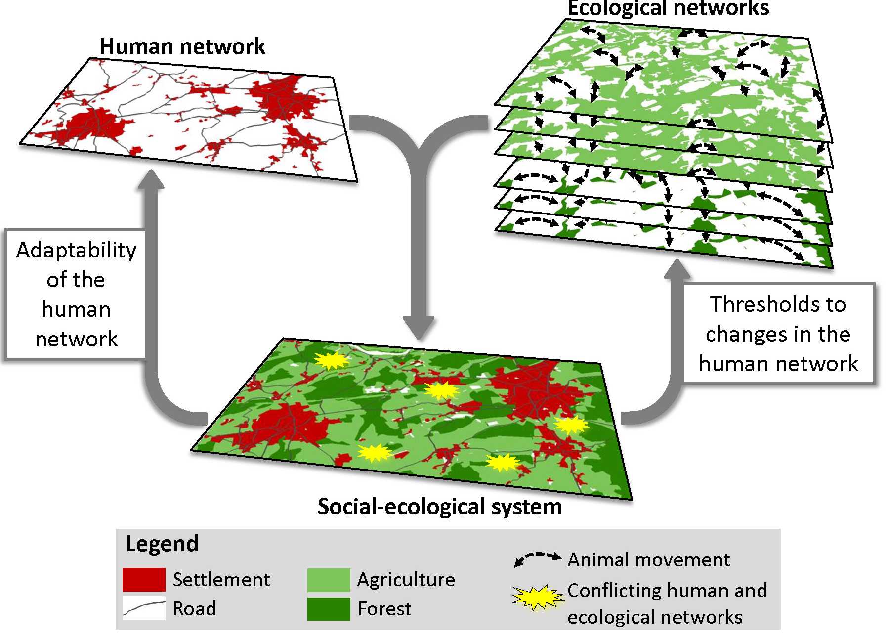
Coupling human and ecological networks for sustainable landscape and transport planning
Human networks, consisting of settlements and roads, are often a threat to the integrity of ecological networks, in which natural habitats are connected with one another. Well-connected ecological networks are necessary to ensure biodiversity and well-functioning ecosystems. On the one hand, most ecosystems have the capacity, up to a certain threshold, to absorb human-made changes and maintain their functioning. On the other hand, human societies have the ability to adapt their land-use or behaviour, to ensure that these ecosystem thresholds are not reached. Due to the complex interactions and trade-offs within and between human and ecological networks, it is difficult to determine how land use and transportation changes will effect biodiversity and what changes are necessary to prevent biodiversity loss. Therefore, the CHECNET project aims to discover thresholds to land-use and traffic changes in ecological networks as well as to determine likely changes in a human network as a result of biodiversity conservation measures. We do so by coupling human and ecological networks in the densely populated Swiss Plateau. The project consists of three work-packages.
EcoGeoIntegralp
Using assembled bio-geo-environmental data for a common study area – the Vaud Alps – the SNF EcoGeoIntegralp project aimed at further understanding and predicting the geographic distribution of four main components – vegetation, soils, geomorphology and hydrology – and their interelations as inputs to the spatial assessment of two ecosystem services: water provision and scenic value of the landscape (Fig. 1).
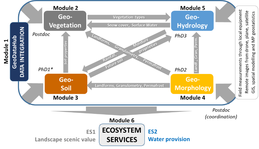
Figure 1: The initial organisation of the EcoGeoIntegralp project, with the six modules, and their interactions.
Successful research was conducted and published on all project dimensions, most planned outputs were produced, and the two project-funded PhD students defended their PhD successfully within the time frame of the project (E. Giaccone, J. Thornton). The third, Unil-funded, PhD student in the soil module also completed her PhD successfully in July 2019 (A. Buri). However, the main postdoc and coordinator of the project (C. Cianfrani) had a 5-months maternity leave during the project, and then left earlier for a permanent position, which limited some developments of the project, such as the 3D simulations of landscape scenic value, which also proved more difficult than expected, but related results could still be obtained with other aspects of landscape’s cultural values as ecosystem services in module 6. Two Unil-funded external postdocs from the Guisan group performed some specific tasks such as forest tree modelling (D. Scherrer) and took over two unfinished studies at the end of the project (temporal soil-vegetation survey and snow/ndvi trends in the Alps; S. Rumpf). Another Unil-funded postdoc, Daniel Scherrer, conducted all forest modelling in the project. Overall, all project collaborators did an excellent work. Also, the second workshop with stakeholders could not be organized as planned by the end of the project (May 2020) due to the covid situation, and was aimed instead for Fall 2020, but was again postponed due to covid. It should take place as soon as the situation will allow a presential meeting, in Spring or summer 2021, again in Château d’Oex, and the final outputs of EcoGeoIntegralp will be presented. Hereafter, we use the project’s module structure to report on the main results and outputs obtained during the three to four years of research (depending on the collaborators involved), from M1 to M6.
M1- GeoDataHub
The GeoDataHub module gathered the geo- and remote sensing data necessary to the project and stored them on a common NAS server accessible by all project members. Worldview 3 satellite image at 1 m resolution were acquired for the whole Vaud Alps study area (Boserup 2018) and some more specifically for the focal area Vallon de Nant. For higher-resolution data, a series of optical and thermal unmanned aerial vehicle (UAV) surveys were carried out in the Vallon de Nant, aimed at identifying interactions between groundwater and surface waters (Vallat 2017). Additionally, codes were developed to access spatially- and temporally-integrated Landsat satellite images using innovative approaches within Google Earth Engine, which allowed generating several new environmental maps for the study area, such as of snow and vegetation indices (Rumpf et al. 2022., Panchard et al. In review) for use in further analyses (task 5.1). The previously sampled soil data were also generalized in space for use in plant models in M2 (Buri et al. 2017, Cianfrani et al. 2018, Cianfrani et al. 2019, Buri et al. 2020)(tasks 5.2 and 5.3). The same spatialization was performed for geomorphological data (Giaccone et al. In prep.-a, Giaccone et al. In prep.-b) and new hydrological maps can be produced for the Nant Valley by the hydrological model in M5.
M2- GeoVegetation
The GeoVeg module produced an integrated review of trends and factors affecting biodiversity and ecosystems in mountain areas under climate and landuse changes (task 2.1), which also contributed to the 1st assessment of the Intergovernmental Science-Policy Platform on Biodiversity and Ecosystem Services (IPBES) for Europe and Central Asia (IPBES 2018, Guisan et al. 2019a). A contribution was also made to biodiversity modelling standards (Araujo et al. 2019) and implemented in a spatial modelling tool (Di Cola et al. 2017). Next, the improvement brought by adding new soil predictors (Buri et al. 2017, Cianfrani et al. 2019, Buri et al. 2020) and new snow predictors (Boserup 2018, Panchard et al. In review) in plant species distribution models (SDMs) was successfully evidenced (task 2.2a), and the influence of geomorphological variables on plant richness and vegetation cover was additionally shown (Giaccone et al. 2019). The role of climate, and the effects of climate scenarios, to predict plants and other above- and below-ground organisms was also assessed, and showed the lower importance of climate to predict below-ground organisms (Mod et al. 2020), except for protist richness (Seppey et al. 2019). A spatial model for the most impactful invasive plant in the study area – Heracleum mantegazzianum S&L – was also finalized and used to discuss socio-economic implications (Shackleton et al. 2020). Some aspects of the plant community modelling approaches developed in previous projects were also finalized in this project, especially regarding the role of top-down macroecological constraints (Mateo et al. 2017), evaluation of community predictions (Scherrer et al. 2018, Scherrer et al. 2020a) and the spatial mismatch in trait and niche characteristics used to assemble species into communities (Guisan et al. 2019b). To assess our capacity to predict in time, two temporal surveys were conducted in the study area by revisiting old vegetation plots, one in forests (Scherrer et al. 2017) and one in grasslands (Rumpf et al. Submitted), providing baselines for future changes. As an input to the geo-hydrology model in M5, tree species distribution models were more specifically built using both correlative (SDM) and mechanistic (TREEMIG) approaches, their capacity to predict future distributions was compared, especially at the upper tree limit (Scherrer et al. 2020b), and the spatial predictions transferred to M5. Finally, plant SDMs were used as input together with Ecosystem Service (ES) maps for spatial conservation planning prioritization in M6 (Vincent et al. 2019, Ramel et al. 2020). The esthetic value of the landscape (task 2.3) proved difficult to realize due to the loss of some resources (maternity leave and earlier departure of the postdoc) and failure, without dedicated budget, to find external partners on the needed 3D simulations (typically working with game development companies), but other approaches are currently under consideration or development, e.g. based on hikers’ walking path utilization rates using connected watches (Rey et al. in prep.) or through social surveys (ongoing in the ValPar.ch project).
M3- GeoSoil
The GeoSoil module synthesized the available knowledge on spatializing soil data in a review paper (task 3.1), which showed that predictive and hybrid (predictive+geostatistical) approaches proved better than purely geostatistical ones, but also that maps including a geostatistical component could not be reliably projected in the future (Cianfrani et al. 2018). Accordingly, data and a predictive modelling pipeline were developed to spatialize soil properties (task 3.2), and the resulting maps were then used to feed plant SDMs in M2 (Buri et al. 2017, Cianfrani et al. 2019, Buri et al. 2020). It showed that pH is both the most important soil predictor for plants but also the soil characteristic (among >40 tested) mapped with the greatest accuracy (Buri et al. 2017, Buri et al. 2020). As pH is also the most important predictor for soil bacteria, the map developed here could also be used in a modelling study of bacteria distribution (Mod et al. In review). Interestingly, pH was also the variable to change most in the temporal study comparing soil and vegetation in resurveyed plots in a > 40-years time interval (Rumpf et al. Submitted), which could serve as a baseline (together with changes in total organic carbon) to define simple soil change future scenarios as input for the prediction of future bacteria distribution under climate changes (Mod et al. In review). Fine-scale modelling of soil properties (task 3.3) was also conducted, with some success to model soil water holding capacity based on the set of vertical soil samples available for the focal part of the study area (Vallon de Nant)(Cianfrani et al. 2019), generalized to the whole Vaud Alps and introduced in improved plant SDMs in M2.
M4- GeoMorphology
The GeoMorpho module accomplished the two main objectives presented in the initial project: 1) it investigated the link between vegetation and geomorphic parameters in three focus sites in the Vaud Alps (task 4.1) and 2) it provided spatially-distributed geomorphological data for improving vegetation models, in particular producing grain size maps and geomorphological maps for significant parts of the study area and a high-resolution permafrost map for the entire study area (tasks 4.2 and 4.3), following the methodology of Deluigi et al. (2017) in the same research group. The investigation of the influence of microclimate and geomorphological factors on vegetation development was based on fieldwork carried out between 2016 and 2019 in the Vallon de Nant. Data about vegetation, ground surface temperature, permafrost occurrence and earth surface processes were collected at around 80 plots. The results show that landform morphodynamics is a key factor, together with growing degree days, to explain alpine plant distribution and community composition (Giaccone et al. 2019). In parallel, a method for the measurement of grain size from UAV-based images was developed. Different algorithms were tested and finally the Basegrain approach was retained (Giaccone et al. In prep.-a). Next, two approaches were used to develop semi-automated geomorphological mapping (SAGM). The first one is the Direct Sampling method, from the multiple point geostatistics family, whereas the second one is the Random Forest, a machine learning technique. Both methods provided encouraging results with slight differences (Giaccone et al. In prep.-b). From this, a geomorphological map of the Vaud Alps was recently produced, but its power to predict plant distribution remains to be tested.
M5 – GeoHydrology
The GeoHydro module produced the model initially planned (tasks 5.1 to 5.3). This model sought to evaluate the utility of one of the most advanced fully-integrated surface subsurface flow codes for simulating hydrological dynamics in steep, snow-dominated, and geologically complex Alpine headwaters, under both present and plausible future climate, and accounting for forest and permafrost conditions. The model was built in three phases. In the first, initial spatial data was gathered to build the model (task 5.1) and additional data was included when available from the other modules (e.g. snow, permafrost, forest scenarios). Given the geological complexity of the study area, the research plan was revised to include an additional task: the development of a 3D model of bedrock geology. This work demonstrates that 3D geological models with appropriate characteristics for hydrogeological applications can be developed in even the most complex settings, and that the lack of such data (at least) should not form an impediment to progressing beyond simple conceptual hydrological models (Thornton et al. 2018). In the second phase, given the importance of complex snow processes to the hydrological functioning of such regions, a novel, code independent, and high resolution (hourly, 25 m) snow simulation, optimisation, and uncertainty framework was proposed (Thornton et al. In revision). Being energy balance-based and additionally accounting for gravitational redistribution, the snow modelling approach extends well beyond that taken in many hydrological models – including otherwise advanced fully-integrated ones – which still mostly rely on index-based snowmelt modelling approaches whose ability to realistically reproduce snow dynamics in complex Alpine terrain is questionable. Two complementary types of snow observations – namely snow extent maps and snow water equivalent time-series – contributed to the estimation of several important but uncertain parameters (Thornton et al. In revision). The results of that model then informed the third phase: the development and calibration of fully-integrated surface-subsurface model was developed using the code HydroGeoSphere (HGS)(Thornton et al. In prep.-b). Streamflow was reproduced at the main gauging station over an independent 11-month evaluation period with a Nash-Sutcliffe Efficiency coefficient of 0.75. The main seasonal signal of the observed groundwater levels could also be broadly replicated, although capturing the observed differences between sites remained elusive, probably due to local scale variability in hydraulic properties. Simulated spatio-temporal patterns of several other important hydrological variables were also visualised to illustrate the model’s coherence and the capabilities of such an approach (Thornton et al. In prep.-b). Finally, in an attempt to assess the potential magnitude of future hydrological change in such regions and unravel its dominant drivers, the model chain was forced with climate, vegetation, and permafrost scenarios that could be expected under “moderate” warming by approximately the year 2075 (Thornton et al. In prep.-a). Direct climatic changes were found to dominate, but increased evapotranspiration due to more extensive forests were predicted to reinforce declining annual streamflows.
M6 – Ecosystem Services assessment
The first ecosystem service (ES) on water provision was assessed using the model developed in M5 (Thornton et al. In prep.-b) and accounting for the geomorphological (e.g. permafrost, snow) and forest tree distribution maps developed in M2 and M4, and as noted above, showed that whilst climate changes are expected to dominate changes in water provision in the medium term, the hitherto rarely assessed impact of contemporaneous forest change are not negligible (Thornton et al. In prep.-a). In contrast, due to the extremely limited present-day permafrost distribution, the hydrological impacts of simulated complete thaw were barely discernable, although this would not be the case at a higher elevation site.
For the second ES, using the Zonation spatial prioritization tool, we combined the plant distribution models with predictions for other taxonomic groups (insects, amphibians and reptiles) to assess present and future spatial conservation priorities in the study area compared to existing ones (Vincent et al. 2019), and expanded this study to include the mapping of 10 ecosystem services (4 provisioning, 4 regulating and 2 cultural ESs) in the prioritization process and showed that putting too high weights on ES could be at the cost of lowering the protection of biodiversity (Ramel et al. 2020). As reported in M2, the landscape scenic value could not be developed as expected, but research is still going on in one of our groups concerning the cultural value of the landscape, notably in the recently started national confederation-funded ValPar project (http://www.valpar.ch ) which will be able to use and acknowledge the early developments made in the EcoGeoIntegralp project.
Collaborators
Elisa Giaccone (PhD student)
James Thornton (PhD student)
Aline Buri (PhD student)
Carmen Cianfrani (Postdoc)
Daniel Scherrer (Postdoc)
Sabine Rumpf (Postdoc)
Grégoire Marietoz (Prof)
Antoine Guisan (Prof)
EcoSoilMod
Summary
Usually, topographic and climatic factors are used to predict plant distribution because they are known to explain plant presence or absence. Soil properties have been widely shown to influence plant growth and distributions. However, edaphic factors are rarely taken into account as predictors of plant species and community distribution models in an edaphically heterogeneous landscape. Or, when it happens, interpolation techniques are used to project soil properties in space. In an heterogeneous landscape, such as in the Alps regions, where soil properties change abruptly as a function of environmental conditions over short distances, interpolation techniques require a huge quantities of samples to be efficient, which is costly and time consuming, and bring more errors than predictive approach for an equivalent number of samples.
In this study we will use predictive approach to reduce the number of soil samples needed and increase the quality of the prediction. In a second step, we will integrate the predicted soil proprieties as predictors into plant SDMs. The two main question we want to address are the following:
1. Can variation in edaphic factors be modelled over large and complex areas using predictive modelling techniques?
2. Does the addition of predicted edaphic factors improve the predictive power of plant species distribution models?
Key words
Soil; edaphic factors; predictive modelling techniques; SDMs; plant species
Collaborators:
Aline Buri (PhD student)
Carmen Cianfrani (Postdoc)
Antoine Guisan (Prof)
Sesam’Alp
Background
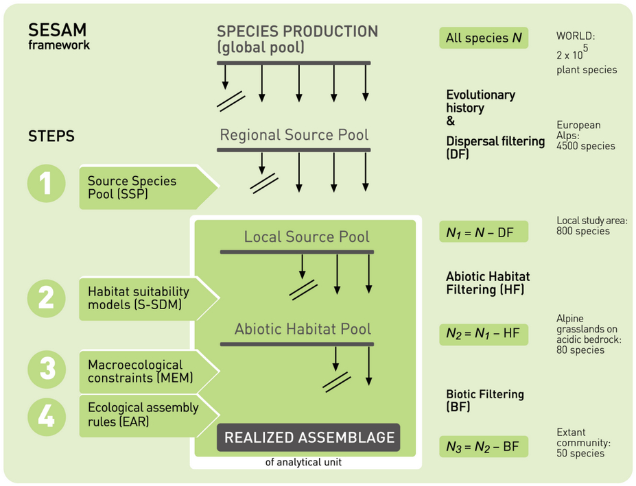
This project is currently my main group’s project. Through my previous SNF projects, robust distribution data have been collected on plants and insects in an intensively sampled study area of the Swiss Alps. These data were used to develop models for the current and future (under climate change) distribution of plant and insect species, and to attempt predicting communities by stacking individual species’ predictions (S-SDMs), according to community modelling schemes, such as the SESAM framework. Important limits to such species and assemblage modelling were however identified.
Specific aims
In this follow-up SESAM’ALP project, I aim at overcoming these limitations by: (i) developing very-high-resolution environmental maps, and accordingly improve associated species distribution predictions, for the study area; (ii) test novel ways to quantify and integrate biotic interactions in S-SDMs and implement the use of macroecological environmental constraints on S-SDMs; (iii) integrate information from larger scales (e.g. invading/colonizing species, uncovered part of the niche) at the regional scale, (iv) test these approaches through novel virtual simulations ; and (v) use these improved models to develop novel regional multi-drivers scenarios of global change impact on plant and insect communities at very high-resolution in the Alps. Methods. Advanced statistical modelling and spatial analyses will be used to improve assemblage and macroecological modelling, and to test and quantify biotic interactions. Dispersal modelling will be used for predicting future distributions of native species, and to model the spread of invasive species. Scripts will be developed for the virtual ecologist approach.
Expected value of the proposed project
The knowledge gained at the end of the project, and the new innovative approaches, tools and datasets delivered, should foster important advances in our capacity of modeling and predicting communities across entire landscapes. In particular, it should allow addressing partially the question: will plant and insect communities evolve into novel assemblages under global changes?
Keywords
Global change, plant and insect communities, species distribution models, assemblage modelling, macroecological models, biotic interactions, integrating scales, very high resolution mapping, environmental carrying capacity, virtual simulations, artificial data, Swiss Alps.
Collaborators
Rui Fernandes (PhD student)
Heidi Mod (Postdoc)
Daniel Scherrer (Postdoc)
Olivier Broennimann (Staff scientist)
Antoine Guisan (Prof)
Sesam’Zoo
Summary
A major challenge of the coming years will be to maintain biodiversity under changing environmental conditions. Anticipation is an important dimension to tackle this challenge, where models play a major role. So far however, our capacity to predict communities from single species has remained limited. We now need to improve existing models and develop new ones to better account for assembly processes. This is the aim of the recently proposed SESAM framework (Spatially-Explicit Species Assemblage Modeling). Arising from this theoretical formulation, I aim to develop, implement, and test an innovative framework to model species assemblage combining many pre-existing approaches to biodiversity prediction to produce improved spatially explicit projections and overcome single methods limitations. As efforts are currently made on plants, this project will be the first to attempt this comprehensively on animal assemblages, here European reptiles, in 3 nested study areas. To ensure its feasibility, it will be developed in a step-by-step way: i) gathering species and environmental data; ii) performing modeling analyses (species distribution models) to obtain the potential composition of assemblages filtered only for abiotic constrains; iii) defining macroecological constraints on community properties through macroecological modeling; iv) identifying species interactions and deriving ecological assembly rules (EARs) for the considered assemblages, to be used as biotic filter; v) using data and results previously obtained to unify all components; for this, I aim to develop a highly original step to integrate the identified EARs in the novel predictive process. I will test the robustness and scale-dependence of all component and of the whole framework; and finally vi) applying the framework to derive a new generation of climate change projections for reptiles assemblage at all scales. Project results will be relevant for both theoretical science and conservation biology.
Key words
SESAM; SDMs; macroecological constraints; ecological assembly rules; climate change; animal communities; European reptiles
Publications
Collaborators:
Manuela D’Amen
Antoine Guisan
ACONITE
Summary
A crucial challenge of the next years will be to conserve biodiversity under climate changes. Anticipation is an essential facet to attack this challenge, where correlative models have a main role. To date, most species richness (SR) modeling methodologies have not accounted for real community assembly processes, or failed to capture the underlying mechanisms. We now need to generate more realistic SR models. The first step is to understand the mechanisms that drive the organization of species at community level, to reach this aim we will test the concept of carrying capacity and disentangle the importance of biogeographical large-scale processes and environmental filters local processes. After that, we could improve the outcome of SR models taking into account the previous point.
In this project, I will develop, implement and test a framework for modeling species assemblages and obtaining spatially explicit projections by taking plants
assemblages as model system. I will proceed step-by-step:
1) I will collect species and environmental data.
2) I will test the concept of carrying capacity and better account for community assembly rules in richness modeling with different tools (ecophylogenetics, remote sensing, and analysis of turnover of betadiversity).
3) I will perform stacked species distribution models.
4) I will define macroecological constraints on community properties through macroecological modeling.
5) Using data and results previously obtained, I will program rules to introduce real community assembly processes in the stacked species distributions models.
6) I will test the robustness and importance of methodological aspects running the models with different parameters.
7) I will apply the previous framework to develop a new generation of climate change projections.
Project results will be relevant for both theoretical science and conservation biology.
Collaborators:
Rubén G. Mateo, Antoine Guisan
Prof. Miguel B. Araújo and his group, Imperial College in London, UK
Prof. Federico Fernández, Castilla-La Mancha University, Spain
MODISALP
Résumé
Alors que la Terre se réchauffe, l’homme détruit les habitats naturels et favorise les invasions biologiques. Dans le contexte actuel de ces grands changements sociétaux et environnementaux, il est important d’évaluer l’impact que peuvent avoir ces facteurs sur l’évolution des écosystèmes et de la biodiversité. Des outils informatiques peuvent être utilisés pour prédire les conséquences des perturbations anthropiques sur les écosystèmes. Un type de modèle très utilisé associe les présences d’espèces observées sur le terrain aux valeurs de différentes cartes environnementales pour dériver des prédictions de la répartition des espèces. Ces prévisions permettent d’anticiper les changements à venir des écosystèmes et de la biodiversité. ECOSPAT à l’Université de Lausanne est spécialisé dans le développement de ce type de modèles.
Ces dernières années, de tels modèles prédictifs ont été développés dans le cadre du projet MODIPLANT (2003-2007) et utilisés pour évaluer l’impact des changements climatiques futurs sur la flore des Alpes vaudoises, mettant en évidence un risque accru pour les espèces alpines et nivales. Ces modèles préliminaires avaient été développés à une résolution de 25 m n’intégrant pas toutes la finesse des variations topographiques définissant les micro-habitats des espèces dans les paysages accidentés de montagne. Un deuxième projet, BIOASSEMBLE (2008-2012), a échantillonné trois groupes d’insectes – papillons, bourdons et orthoptères –dans les Alpes vaudoises pour étudier les relations plantes-insectes et évaluer dans quelle mesure celles-ci influencent la distribution des plantes. Un troisième projet, MICROBIAL BIOGEOGRAPHY (en cours), s’attache enfin à étudier la distribution spatiales et environnementale, la relation avec les espèces végétales et à modéliser la distribution des micro-organismes du sol (champignon et bactérie). Un nouveau projet – MODISALP – démarre maintenant avec pour but de développer des cartes environnementales à très haute résolution pour prédire la distribution des espèces végétales, d’insectes et de micro-organismes du sol.
Le projet MODISALP est donc la continuation logique des projets précédents. Il poursuit le même objectif d’évaluer l’impact des changements climatiques sur la distribution des espèces, de la biodiversité et des écosystèmes, mais avec de nouvelles données et de nouveaux moyens d’analyses. Les Alpes offrent de ce point de vue un formidable laboratoire naturel. Durant les campagnes de terrain des projets précédents, >900 relevés de végétation, >600 relevés d’insectes (papillons, bourdons, orthoptères) et >300 relevés de microorganismes du sol ont été échantillonnés. Les analyses qui ont suivi ont permis de mieux comprendre les facteurs influençant la distribution des biodiversités végétale et animales, dans le but ensuite de dériver des modèles et des scénarios d’impact du changement climatique sur les flore et faunes alpines. Ces projets contribuent donc déjà beaucoup en soi à la connaissance actuelle sur les écosystèmes et la biodiversité dans les Alpes vaudoises. Des résultats préliminaires avaient par exemple prédits des migrations en altitude et des pertes d’habitats pour de nombreuses espèces alpines. Lors du développement de ces premiers modèles, certains facteurs tels que le sol ou les relations entre espèces (plantes et insectes) n’avaient cependant pas pu être considérés, et les modèles avaient une précision géographique limitée. Des analyses préliminaires incluant les facteurs du sol et les microorganismes ont montrés l’importance de certaines propriétés chimiques du sol pour la distribution des espèces végétales. Les micro-organismes du sol, semblent aussi influencer la végétation, et par cascade, la faune.
Nous souhaitons aujourd’hui compléter les dimensions manquantes – sol, interactions plante-insectes-microbes, meilleure résolution des données, meilleures mesures de température – dans de nouveaux modèles développés à très haute résolution. Ce dernier aspect en particulier est mené en collaboration avec le laboratoire LASIG de l’EPFL (Dr. S. Joost), celle des interactions plantes-sols avec l’institut des sciences de la Terre (Dr. T. Prof. E. Verecchia) et celle des interactions plantes-micro-organismes avec le département de microbiologie fondamentale (Prof. J. van der Meer), tous deux à l’Université de Lausanne (Unil).
Current collaborators
Jean-Nicolas Pradervand, Antoine Guisan
HERACLEUM
Potentiel envahissant de la Berce du Caucase dans les Préalpes vaudoises
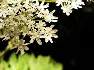 | La Berce du Caucase (Heracleum mantegazzianum), une espèce exotique envahissante originaire du Caucase, a été introduite en Suisse romande à partir de la fin du XIXème siècle. Depuis, l’espèce s’est largement répandue causant des problèmes économiques, écologiques et de santé publique. Montagnarde dans son aire de répartition d’origine, la plante pourrait devenir problématique en Suisse et menacer ainsi la flore de montagne. |
Récolte de données et modélisation
Deux travaux de diplôme à l’Université de Lausanne (Christian Benetollo en 2005 et Florian Dessimoz en 2006) ont permis de récolter un nombre important de sites envahis par cette plante géante. L’état de l’invasion de la Berce du Caucase dans les Préalpes vaudoises a été évalué en modélisant sa distribution potentielle et en estimant sa densité actuelle et future (si l’espèce occupait toutes les zones potentiellement favorables à son développement).
Deux différentes estimations ont été testées : une estimation basée sur un échantillonnage aléatoire stratifié adaptatif (suggérée par Thompson) qui évalue la situation actuelle et une estimation basée sur les modèles issus de l’échantillonnage qui permet d’approcher la taille population future en cas d’invasion complète de la zone d’étude.
Les modèles de distribution potentiels ont également permis de mettre en évidence les conditions écologiques favorable à l’établissement de la Berce du Caucase : l’espèce préfère les sols profonds et productifs, des sites bien exposés aux rayonnements solaires et une proximité aux rivières.
Analyses génétiques
La connaissance de la structure génétique d’une plante envahissante tel la Berce du Caucase constitue un outil intéressant pour la mise au point d’un système de gestion qui puisse mené au contrôle voir même à l’éradication de cet organisme dans les zones envahies (Abdelkrim et al. 2004 : Conservation Biology, 19, 1509-1518).
L’outil génétique peut aussi répondre à des questions plus fondamentales surtout si l’historique de l’invasion est peut connue ou lacunaire. Ces questions peuvent être :
- d’où sont venu ces envahisseurs (ex. détermination d’une population source dans la zone native ou d’une population source dans la zone envahie, tels que les Jardins Botaniques Alpins)
- combien de fois ont-ils été introduit dans la zone d’étude
- quels procédés génétiques (dérive, consanguinité, etc) ont agit sur les populations à leur arrivée dans un nouvel environnement
- quelles sont le routes de dispersions de l’espèce (ex. routes cantonales, rivières, chemin de fers, etc)
Le cas des Préalpes Vaudoise offre une zone d’étude particulièrement intéressante car cette zone, fortement envahie par la Berce du Caucase est aussi caractérisée par la présence de l’homme (le vecteur majeur de dispersion de cette plante). Dans cette étude, des populations de Berce du Caucase ont été échantillonnées dans la totalité des Préalpes Vaudoise (plus ou moins cinq populations par communes) ainsi que deux populations dans le Valais, une dans le Tessin et une à Lausanne.
Des outils de génétique moléculaire à forte résolution (microsatellites) ont été utilisés pour caractériser génétiquement toutes les populations échantillonnées. De plus, un échantillonnage réalisé dans la zone native de la plante (Caucase, Russie du sud-ouest) a été réalisé par une collègue de Prague (S. Jahodova). Cet échantillonnage permettra de relier les populations trouvées dans les Préalpes à celles se trouvant dans leur zone native et de tirer des conclusions plus concrètes sur les procédés évolutifs qui ont agit lors de l’introduction de la Berce du Caucase en Suisse.
Prévention et lutte
| Les communes des Préalpes vaudoises ont été informées des emplacements des sites envahis sur leur territoire respectif. Dans le courrier transmis aux communes vous trouverez un aperçu historique de l’apparition de la berce du Caucase en Suisse romande et une carte des Préalpes vaudoises sur laquelle les sites envahis par cette plante exotique envahissante sont mentionnés.Une fiche technique sur la berce du Caucase élaborée par Florian Dessimoz a également été transmise aux communes afin de permettre une meilleure diffusion des informations nécessaires à l’éradication de l’espèce. | 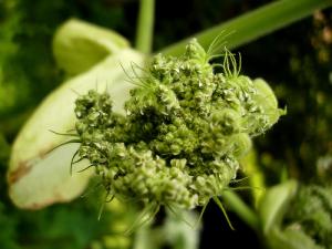 |
Vous y trouverez une description détaillée des caractéristiques et de l’écologie de l’espèce ainsi que les moyens de lutte à appliquer pour une tentative d’éradication.
fiche_berceducaucase2.pdf (784 Ko)
fiche_berceducaucase.pdf (5070 Ko)
courrierberce.pdf (485 Ko)
Dans les Préalpes vaudoises, une interaction intercommunale devrait être mise en place afin d’éliminer cet organisme indésirable.
Collaborateurs actuels
Antoine Guisan
Olivier Broennimann
Blaise Petitpierre
Anciens collaborateurs
Florian Dessimoz
Christian Benetollo
Philippe Henry
Microbial biogeography
Summary
Background
A project is currently under way that investigates community assembly and biotic interactions in mountain meadows communities, and how these could be integrated into predictions of species distributions. More than 900 plots were sampled for plants and among these >150 for butterflies and bumblebees across a 700 km2 mountainous study area in the Western Swiss Alps. Species traits and phylogeny data are additionally available for the >250 most abundant plant species and >130 butterfly species. This study should improve our understanding of how plant and insect communities assemble in geographic space, under current and future climate. In this context, soils were also surveyed in the same plant communities (2008-2009), resulting in soil being sampled in >250 distinct sites along a wide elevation gradient. For 205 of these soil samples, DNA extractions were conducted in addition to standard biogeochemical analyses, yielding a set of soil DNA samples of unprecedented large size. To our knowledge, no other dataset exists that is as exhaustive, and spatially-explicit at such very high spatial resolution (potentially <1m) and large extent (>700km2 Pyrosequencing of soil DNA is currently ongoing only for fungal communities, but other biotic groups could also be investigated.
Aim
Here, we intend to extend the pyrosequencing of soil DNA to microbial communities and then test several hypotheses on the geographic distribution and ecology of fungal and microbial soil communities, and their relationship to macro-organisms (plants, insects). We intend more particularly to answer the main, still largely unanswered question: Do soil fungi and bacteria taxa exhibit biogeographic patterns? Or alternatively, are all taxa everywhere? If they do exhibit non-random geographic and environmental patterns, are these similar to those of macro-organisms? If similar, then how interdependent are distributions of micro- and macro-organisms? If distinct, then what factors are responsible for the divergence? And more specifically, which factors explains the distribution of microbial taxa in such mountain landscape? Do they affect – and if so how – the assembly of macro-organisms like plants? Finally, we will use all findings to assess the potential impact of climate and landuse changes on microbial communities.
Methods
The DNA samples already extracted for the 205 2 m x 2 m plots described above will be used as initial input. A first PhD project (subproject 1) will focus on obtaining high-throughput sequencing data of bacterial communities, using high-depth phylogenetic analysis to obtain genus and species level classifications and microbial community composition. Together with data on fungal communities, it will then be to analyze their distribution and ecology with computer intensive bioinformatic and advanced statistical methods, in combination with vegetation composition, soil conditions, and topo-climatic and landuse characteristics. If needed, complementary field sampling may be performed. A second PhD project (subproject 2) will focus on developing a very high-resolution spatial modelling framework and use it to assess and predict the distribution of microbial operational taxonomic units and their assemblages under current and future climate.
Collaborators
Eric Pinto (PhD student), Erika Yashiro (Post-Doc), Jan Roelof Van der Meer (Prof), Antoine Guisan (Prof)
RechAlp.vd
Une nouvelle plateforme Unil de support pour la recherche transdisciplinaire dans les Alpes vaudoises.
Elle permet de consulter, grâce à une interface web conviviale, les métadonnées pour 3’546 documents dans 13 domaines thématiques. Nous espérons que vous serez nombreux à tester ce nouvel outil, à nous rapporter vos expériences d’utilisateurs et idéalement à nous informer sur l’existence de données encore non répertoriées.
lien externe: rechalp.unil.ch/
Bioassemble/Modiplant
BIOASSEMBLE (2009-2012): Assessing the importance of biotic interactions for predicting the impact of climate change on the future distribution of plant assemblages
MODIPLANT (2003-2009): Providing more informative predictions of climate change impact on alpine plant species distribution
Summary
BIOASSEMBLE (2009-2012)
Background. In my previous SNF project (MODIPLANT; grant nr 110000), niche-based species distribution models were successfully developed for predicting the fate of nearly 300 mountain plants in face of severe climate change. Scenarios revealed a great sensitivity of the alpine flora, with many high elevation species at severe risk of extinction. However, biotic interactions were not taken explicitly into account in these projections. It is currently debated whether changed biotic interactions may also change – and if so, to which extent – the outcome of such projections. To test this hypothesis, biotic interactions need to be more explicitly incorporated into the modelling process. In particular, future plant communities need to be predicted by selecting those species potentially co-occurring from a larger pool of candidate species predicted at a suitable site. Interactions with other organisms, such as pollinator insects, also need to be considered.
Specific aims. In this follow-up project, we aim at incorporating (1) plant-plant interactions (assembly rules) and (2) plant-insect interactions into niche-based statistical models of species distribution, and test whether their inclusion can change the outcome of projections in a warmer future. The two subprojects will run in parallel and share data.
Methods. A large field survey involving four teams will be conducted throughout the study area to complement existing vegetation plots and additionally sample soils and the entomofauna. In the first subproject, we will look for patterns of plant co-occurrences and test if and how identified interactions can be used to filter predictions – using both bottom-up assembly and top-down controls (e.g. species-energy) – of plant communities, and modify their future composition and structure. In the second subproject, we will look for patterns of plant-insect co-occurrences, and similarly assess whether a change in their respective distributions may lead to limited matching of plant and specialist insects in a warmer future, and as a result to disruption of some communities or ecosystems.
Funding requested. Funding is requested for only one PhD student (in subproject 2), three year of GIS technician (at 50%) and some months of field and lab technicians. The second PhD student (in subproject 1) will be granted by Unil as matching funds. A postdoc from the ECOCHANGE EU-project will also actively collaborate on the project.
Expected value of the proposed project. With this project, we aim at providing: (i) a better understanding of biotic interactions (especially between plants and insects, and within each group) and how they shape species distribution, (ii) an improved approach to modelling biodiversity, that considers both top-down controls on and bottom-up assembly of communities, and (iii) ecologically more realistic projections of future plant distributions. Although not its primary aim, this project will also contribute indirectly to (iv) build a comprehensive inventory of plant and insect species in the Western Swiss Alps, and (v) as all plots will be marked in the field with buried metallic bars, our sampling will also contribute to the set-up of an impressive biomonitoring network in this area, which will be available in the future to test model predictions.
MODIPLANT (2003-2009)
Alpine ecosystems were identified as potentially very sensitive to climate change. For instance, it has been hypothesized that alpine plants with narrow niche should be at greatest risk of extinction. However, we hypothesize here that projections made for these species at the European scale can differ greatly from those obtained at finer scale, e.g. due to the presence of micro-topographic refugias, and thus, species’ turnover calculated on large scale may be entailed with errors. We also hypothesize that lack of consideration for validation and uncertainty prevents proper interpretation of model projections, and that some biological traits and dispersal ability may explain species’ vulnerability.
This project aimed primarily at providing more informative predictions of climate change impact on alpine plant species distribution. By doing so, it contributed to improve our fundamental knowledge of species distributions and related ecological processes. The project had five main aims: 1-compare projections at various scales, 2-assess model robustness, 3-take dispersal into account, 4-estimate uncertainty, 5- assess species’ sensitivities.
A large field survey had already been conducted during the summers 2002-2004 and 550 nested vegetation plots (including all vascular plant species, nested surfaces of 1, 4, 16 and 64 sq-m) are now available between 450 and 3200 m over a study area of 700 sq-km (Swiss Western Alps). These were used in conjunction with a GIS environmental data base to fit our models and test our hypotheses.
Current collaborators
BIOASSEMBLE: A. Guisan, A. Dubuis, L. Pellissier, P. Vittoz, with help from L. Maiorano
Past collaborators / students
MODIPLANT: C. Randin, P. Pearman, R. Engler, Y. Hautier, R. Milleret, G. Vuissoz, H. Jaccard
Hotspots
(V. Savolainen et al.)
The HOTSPOTS EST (Marie Curie Actions, Host fellowships for Early Stage Research Training) involves a consortium of training institutions designed to provide the ESRs with both the multidisciplinary training necessary and the relevant field experience essential for their future careers in biodiversity and/or conservation. There are 9 core-partners, including the University of Lausanne, 1 NGO and 5 other organisations.
Summary
The Earth’s biodiversity is threatened by human activities yet the sustainable use of biodiversity is fundamental to the future development of humanity. Because financial and human resources for nature conservation are limited, it is appropriate to focus efforts on the richest and most threatened reservoirs of biodiversity. About 25 such biodiversity hotspots have been recently proposed based on available data on plant and vertebrate species richness, endemism and threat status (www.biodiversityhotspots.org). While there is a wide consensus on the choice and geographical delimitation of hotspots, the dynamics of biodiversity in these hotspots and the ecological impacts of predicted biodiversity loss are still only poorly understood (e.g. Local endemism within the western Ghats-Sri Lanka biodiversity hotspot. Science 306, 2004). In collaboration with partners in FP6-third countries, the European
HOTSPOTS consortium will work towards increasing the knowledge and understanding of biodiversity hotspots, including the Mediterranean Basin and some European overseas territories Applying field, molecular and bioinformatics approaches to flagship plants and animals, HOTSPOTS will train a new generation of multidisciplinary biologists in state-of-the-art methods of evolution, ecology, and conservation.
Website: http://www.kew.org/hotspots
Current collaborators
D. Pio, A. Guisan, N. Salamin
Eryngium
Gestion des plantes rares dans un monde en changement : Vers un rôle central des modèles dans la conservation
Résumé
L’utilisation des modèles prédictifs de distribution d’espèces s’est fortement développée ces dix dernières années en écologie et biogéographie. Ces modèles permettent de prédire la distribution géographique des espèces en fonction de caractéristiques environnementales. Cependant, en biologie de la conservation, ces modèles sont encore sous-utilisés pour la gestion des espèces et des milieux rares et menacés. Avec l’appui de la MAVA, les recherches menées dans ce domaine depuis 2003 par le laboratoire ECOSPAT de l’université de Lausanne ont ainsi permis de développer des protocoles d’utilisation de ces modèles pour la planification d’échantillonnage, permettant de favoriser la découverte de nouvelles populations de plantes rares sur le terrain. Des tests de cette approche basée-modèle, effectués sur le terrain entre 2003 et 2006, ont permis de démontrer son efficacité. Cette approche novatrice n’ayant été que très récemment proposée, ces modèles ne sont cependant pas encore utilisés en pratique pour la gestion des espèces rares et menacées. Par ailleurs,, deux applications complémentaires très prometteuses de ces modèles, ayant déjà fait l’objet de tests préliminaires dans notre groupe, mériteraient maintenant également d’être développées et diffusées auprès des gestionnaires. Il s’agit d’une part de poursuivre le développement de nouveaux critères de menace UICN (World Conservation Union) basés sur les prédictions de ces modèles, et d’autre part d’évaluer l’impact additionnel des changements climatiques sur les distributions futures des espèces rares. La combinaison de ces deux nouvelles dimensions pourrait permettre d’anticiper un éventuel changement du degré de menace des espèces rares sous l’effet des changements climatiques, et de pouvoir ainsi développer, dès aujourd’hui, les mesures de conservation qui s’avéreront nécessaires demain. Ces nouvelles perspectives visent directement à mettre en application dans les procédures de gestion des espèces rares et menacées les résultats des trois années de recherche passées. Cette procédure sera principalement testée sur une sélection d’espèces de la base de données des espèces rares et menacées de Suisse (CRSF). A l’issue de ce test, un protocole simplifié présentant la démarche entière d’utilisation des modèles prédictifs dans la gestion des espèces rares sera rédigé, diffusé et, dans la mesure du possible, évalué par des gestionnaires. Ce nouveau projet comporte donc une forte dimension intégrative et de transfert de connaissance et de technologie vers les gestionnaires.
Publications
Le Lay G., Engler R., Franc E., Guisan A., 2010. Prospective sampling based on model ensembles improves the detection of rare species. Ecography 33(6) pp. 1015-1027
Guisan A., Broennimann O., Engler R., Vust M., Yoccoz N. G., Lehmann A., Zimmermann N. E., 2006. Using niche-based models to improve the sampling of rare species. Conservation Biology 20(2) pp. 501-11
Engler R., Guisan A., Rechsteiner L., 2004. An improved approach for predicting the distribution of rare and endangered species from occurrence and pseudo-absence data. Journal of Applied Ecology 41(2) pp. 263-274
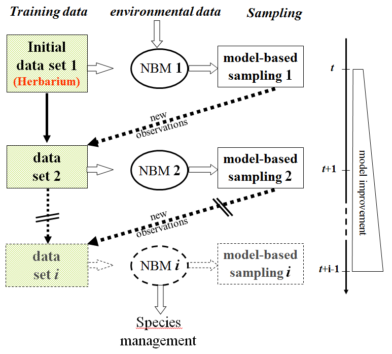
Figure – Analytical procedure illustrating the iterative model-based sampling process. From Guisan et al. 2006 Conservation Biology
Collaborateurs
Robin Engler, Luca Rechsteiner, Olivier Broennimann, Erika Frank, Gwenaelle Le Lay, Pascal Vittoz, Antoine Guisan
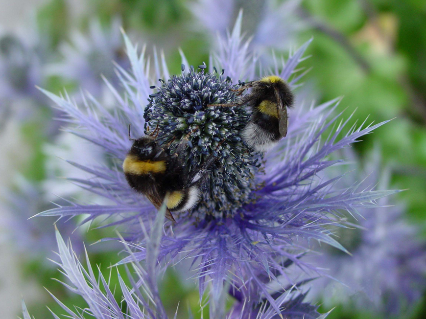
Eryngum Alpinum
Habitalp
Alpine habitat diversity WP7
See: http://www.habitalp.de/englisch/seiten/unterseiten/wp7.htm
Summary
The HABITALP Project deals with the diversity of alpine habitats and its goal is to monitor long term environmental changes in these habitats. This is performed with the help of CIR (Color Infra Red) aerial photographs. Our role in this project was to lead workpackage 7. In this WP7, the CIR areas identified in the aerial photographs of workpackage 4 and the correlated NATURA 2000 areas from work package 5 are used to develop parameters that describe the biodiversity of the landscape in the participating alpine protected areas. This is achieved through GIS modelling.
The development work will follow the example of one or several protected areas with existing interpretation standards in line with HABITALP standards. The transmission of these same measurement methods to all participating project partners will allow for an alpine wide comparison of biodiversity.
Landspot
Landscape potential for animal species colonization, dispersal and survival
For more information on the whole project, see https://www.unil.ch/ecospat/landspot
Summary
We propose a new approach to test a series of hypotheses related to the spatial distribution of animal species in Switzerland. Based on modeling the distribution of habitat units (in the sense of biota) from GIS analyses and statistical analyses, the proposed approach is original in the sense that it will also allow the modeling of the distribution of a group of species of similar ecological requirements (e.g. guilds). Furthermore, it is flexible and powerful, as it does not require species’ absence data, and is fast and can be run easily for many species at once.
Most previous modeling studies took a species-specific approach to habitat, fitting a model between occurrences of a species and a set of environmental explanatory predictors, thus modeling the species’ ecological niche. The approach we propose here is more habitat-specific, since the distribution of pre-defined habitat units is modeled first, and the simulated habitat map is then used to predict animal distribution.
The development of the simulated map of habitats will be based on a set of available data, among which the most important are: (1) the GEOSTAT land-use information package developed by the Swiss Federal Office of Statistics (OFS 1999); (2) The Swiss vegetation map of Hegg et al. (1993); (3) The Digital Elevation Model (DEM) and related data; and (4) remotely sensed data: MODIS and LANDSAT satellite scenes. The latter data will be used as a potential substitute for vegetation data, which should allow for the delineation of a new map of habitats, independently of any previous vegetation mapping.
Using this map, we will predict the spatial distribution of animal species (i) from field observations, (ii) from theoretical ecological profiles of species, and (iii) using classical predictive distribution models. We shall evaluate the impact of the use of these several modeling approaches on the study of animal distribution. Model predictions will be evaluated using traditional methods as far as accuracy and error propagation assessment are concerned. As a side application in conservation biology, modeled species’ habitat maps will be used to assess habitat connectedness and long-term species survival for those species for which distribution was adequately predicted and which distribution exhibits a critical level of fragmentation.
PNR48
Transformation rates of Alpine landscapes and surrounding areas: Potential threats and benefits to people and selected species (F. Kienast et al., WSL ZH)
See http://www.wsl.ch/projects/t-rates/welcome-en.ehtml
NFP48 site: www: http://www.nrp48.ch
Summary
Landscapes change steadily. But changes do not proceed with the same speed everywhere. During the past century until nowadays, the Swiss Plateau has seen heavy building activities and an increase in farming intensities driven by the upcoming industrialisation and mechanisation. Such developments have, with a certain delay, also reached the Alpine valleys, where traditional farming systems have been drastically reduced, whereas tourist facilities increased heavily in number.
It is the aim of this project to investigate landscape changes and their speed (transformation rate) during the last century in two selected regions, situated between the Swiss plateau and the Alps. Furthermore, we attach importance to the study of the reasons, effects and consequences of the landscape changes reconstructed in these regions. An interdisciplinary team of three Ph.D. students investigates different aspects of the landscape change and finally compiles these results to achieve a new, holistic view. In this context, we investigate the reactions of animal and plant species to changes and transformation rates in a landscape ecological study. The project is part of the National Research Programme 48 ‘Landscapes and Habitats of the Alps’, where different projects are focussed on a sustainable use of the Alpine environment.
ECOCHANGE
Challenges in assessing and forecasting biodiversity and ecosystem changes in Europe
A range of advanced modelling approaches has been used so far to assess the impact of global change on biodiversity and ecosystems.
The project ECOCHANGE proposes to improve some of these approaches by:
* integrating different modelling approaches currently in use (niche-based, dynamic, dispersal, etc.), and by developing robust methodologies to estimate uncertainties associated with these projections.
* generating required new data (paleo & migration) by using innovative DNA-based approaches, and global change scenarios.
* testing niche conservatism and temporal evolution of biological communities.
* using the new data in improved and integrated models to make projections more robust and realistic.
* testing these approaches in case study areas and expanding the current projections to all of Europe.
EcoChange is divided into nine “activities”. The main scientific work is done within Activity 1 to 6. Activities 7 to 9 complement the project by providing dissemination, training and management.
* Activity 1: Assembling available data and complementary sampling
* Activity 2: New DNA-based paleo data
* Activity 3: New DNA-based dispersion data
* Activity 4: Niche and community stability
* Activity 5: Improved modelling and uncertainty assessment
* Activity 6: Integration, projections, conservation and ecosystem services
Our group at Unil is primarily involved in Activities 4 and 5 and secondarily in Activities 1 and 6. The group of Jérôme Goudet at Unil/DEE is involved in Activity 2.
External link: www.copernicus.eu/en/challenges-assessing-and-forecasting-biodiversity-and-ecosystem-changes-europe
Collaborators
Pascal Vittoz
Luigi Maiorano
Julien Pottier
Gertrud Schorr
Carmen Cianfrani
Centaurea
Summary
Centaurea is a subproject of the workpackage 3 (WP3.1) of the Project NCCR Plant Survival in Natural and Agricultural Ecosytems which projects ranged from essential research on the physiological processes inside the plants to studies on the plants’ interactions within natural and agricultural ecosystems. The aim of WP3 was to understand the spreand and impact of invasive plants. At Unil, we investigated in particular the invasiveness and ecosystem impact below and above the species level by refining and extending the Centaurea stoebe.
The spotted knapweed, Centaurea stoebe, originates from Europe. It was probably introduced to North America at the end of the 19th century mixed in with alfalfa seeds that were being traded at that time. It has since become an important invasive species in crops causing major financial losses. To biologists, this species represents an ideal model for understanding the causes and consequences of introducing an exotic plant to a region. The establishment and invasive capacities not only depend on the plant’s intrinsic traits (morphology, genotype, reproduction method, toxin production,…), but also on the environmental conditions of the area where it is being introduced. Furthermore, they depend on the species’ ability to adapt to its new environment such as, for example, the possible consequences of a change in its ecological niche. Studying invasive plants in both their place of origin and in the invaded area is necessary in order to determine which biological factors and which environmental changes could have contributed to their successful proliferation. We could then better predict the future distribution of these plants in their new environment.
Publications
Broennimann O., Mráz P., Petitpierre B., Guisan A., Müller-Schärer H., 2014. Contrasting spatio-temporal climatic niche dynamics during the eastern and western invasions of spotted knapweed in North America. Journal of Biogeography 41 pp. 1126-1136
Guisan A., Petitpierre B., Broennimann O., Daehler C., Kueffer C., 2014. Unifying niche shift studies: insights from biological invasions. Trends in Ecology and Evolution 29(5) pp. 260-269
Broennimann O., Fitzpatrick M.C., Pearman P.B., Petitpierre B., Pellissier L., Yoccoz N.G., Thuiller W., Fortin M.J., Randin C.R., Zimmermann N.E. et al., 2012. Measuring ecological niche overlap from occurrence and spatial environmental data
Hordijk W., Broennimann O., 2012. Dispersal routes reconstruction and the minimum cost arborescence problem. Journal of Theoretical Biology 308 pp. 115-122
Mráz P., Spaniel S., Keller A., Bowmann G., Farkas A., Singliarová B., Rohr R.P., Broennimann O., Müller-Schärer H., 2012. Anthropogenic disturbance as a driver of microspatial and microhabitat segregation of cytotypes of Centaurea stoebe and cytotype interactions in secondary contact zones. Annals of Botany 110(3) pp. 615-627
Treier U.A., Broennimann O., Normand S., Guisan A., Schaffner U., Steinger T., Müller-Schärer H., 2009. Shift in cytotype frequency and niche space in the invasive plant Centaurea maculosa. Ecology 90(5) pp. 1366-1377
Broennimann O., Guisan A., 2008. Predicting current and future biological invasions: both native and invaded ranges matter. Biology Letters 4(5) pp. 585-589
Broennimann O., Treier U. A., Muller-Scharer H., Thuiller W., Peterson A. T., Guisan A., 2007. Evidence of climatic niche shift during biological invasion. Ecology Letters 10(8) pp. 701-709
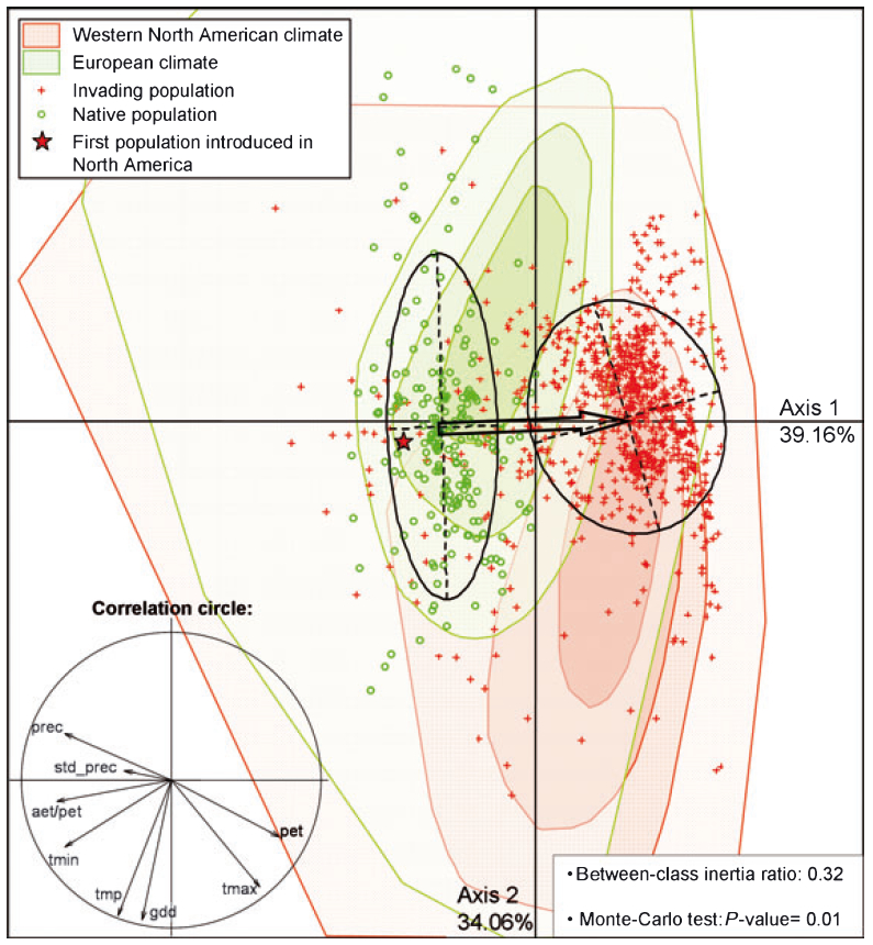
Figure – Bioclimatic space with illustration of niche shift. The position of occurrences, from the native and invaded ranges along the principal climatic gradients is indicated with green dots and red crosses respectively. The red star shows the climatic position of the first population introduced in North America (Victoria, BC). The arrow linking the centroids of the 1.5 inertia ellipses for the two ranges illustrates the niche shift. The enclosed correlation circle indicates the importance of each bioclimatic variable on the two significant axes of the principal component analysis (PCA), which jointly explain 73.22% of the variance in the data. A between-class analysis, yielding a betweenclass inertia ratio, was further conducted and tested with 99 Monte-Carlo randomizations. The convex hulls indicate the prevalence (25, 50, 75 and 100% of sites included) of the global climate conditions in the two ranges. Climatic predictors are: tmp = annual mean temperature, tmax = maximum temperature of the warmest month, tmin = minimum temperature of the coldest month, prec = annual sum of precipitation, std_prec = annual variation of precipitation, gdd = annual growing-degree days above 5 C, aet/pet ratio of actual to potential evapotranspiration, pet = annual potential evapotranspiration.
From Broennimann et al. 2007, Ecology Letters
head
A. Guisan (Lausanne)
H. Müller-Schärer (Fribourg)
senior scientists
U. Schaffner (CABI)
post-docs
O. Broennimann (Lausanne)
A.R. Collins (Fribourg)
P. Mraz (Fribourg)
Ph.D students
B. Petitpierre (Lausanne)
M. Hahn (Fribourg)
Y. Sun (CABI)
Centaurea stoebe
Treemod
Modelling tree species distribution in Switzerland (with N.E. Zimmermann, WSL)
Summary
This project results from a tight collaboration between A. Guisan and Nick Zimmermann (at WSL Birmensdorf).
It makes use of Federal Swiss Forest inventories to test and develop predictive distribution models. In this way, it creates a natural bridge between projects in our ECOSPAT group (spatial modelling) and those in Nick’s group (ecological modelling mostly focused on forests).
The data sets used in this project were for instance used as one of the six data sets used by the NCEAS « Predicting species occurrences » group (A.T. Peterson & C. Moritz chairs; see Elith et al. in prep, Guisan et al. in prep.) in Santa Barbara.
Current collaborators
A. Guisan, N. E. Zimmermann