The spatio-temporal variability of bedload transport processes poses considerable challenges for bedload monitoring systems. One such system, the Swiss plate geophone (SPG), has been calibrated in several gravel-bed streams using direct sampling techniques. The linear calibration coefficients linking the signal recorded by the SPG system to the transported bedload can vary between different monitoring stations by about a factor of six, for reasons that remain unclear. Recent controlled flume experiments allowed us to identify the grain-size distribution of the transported bedload as a further site-specific factor influencing the signal response of the SPG system, along with the flow velocity and the bed roughness. Additionally, impact tests performed at various field sites suggested that seismic waves generated by impacting particles can propagate over several plates of an SPG array, and thus potentially bias the bedload estimates. To gain an understanding of this phenomenon, we adapted a test flume by installing a partition wall to shield individual sensor plates from impacting particles. We show that the SPG system is sensitive to seismic waves that propagate from particle impacts on neighboring plates or on the concrete bed close to the sensors despite isolating elements. Based on this knowledge, we designed a filter method that uses time-frequency information to identify and eliminate these “apparent” impacts. Finally, we apply the filter to four field calibration datasets and show that it significantly reduces site-to-site differences between calibration coefficients and enables the derivation of a single calibration curve for total bedload at all four sites. A copy is freely available here.
News
New Paper Published : Hydrological drivers of bedload transport in an Alpine watershed
Understanding and predicting bedload transport is an important element of watershed management. Yet, predictions of bedload remain uncertain by up to several order(s) of magnitude. In this contribution, we use a five-year continuous time-series of streamflow and bedload transport monitoring in a 13.4 km2 snow-dominated Alpine watershed in the Western Swiss Alps to investigate hydrological drivers of bedload transport. Following a calibration of the bedload sensors, and a quantification of the hydraulic forcing of streamflow upon bedload, a hydrological analysis is performed to identify daily flow hydrographs influenced by different hydrological drivers: rainfall, snowmelt, and combined rain and snowmelt events. We then quantify their respective contribution to bedload transport. Results emphasize the importance of combined rain and snowmelt events, for both annual bedload volumes (77% on average) and peaks in bedload transport rate. A non-negligible, but smaller, amount of bedload transport may occur during late summer and autumn storms, once the snowmelt contribution and baseflow have significantly decreased (9% of the annual volume on average). Although rainfall-driven changes in flow hydrographs are responsible for a large majority of the annual bedload volumes (86% on average), the identified melt-only events also represent a substantial contribution (14% on average). The results of this study help to improve current predictions of bedload transport through a better understanding of the bedload magnitude-frequency relationship under different hydrological conditions. We further discuss how bedload transport could evolve under a changing climate through its effects on Alpine watershed hydrology. A copy is freely available here.
New Paper Published : Bedload transport: Are we doing restoration right in the face of alpine climate change?
Alpine landscapes are undergoing climate warming at a higher rate than other regions of the world. The current and future impacts of this warming on the cryosphere (snow and ice) and their implications for stream flows are now well known and there exist predictions of how snow, ice and river flows are likely to evolve in Alpine environments over the 21st century (e.g. [1, 2, 3]). There is no doubt that such changes will also impact bedload transport in Alpine streams. Bedload transport in many Alpine streams is, however, also impacted significantly by the direct effects of human activities such as hydropower and gravel extraction (e.g. [4, 5]). These direct effect have dominated the concerns of bedload management or river restoration over the last decade or more. It is therefore a logical question to ask whether or not river restoration projects and the bedload management policies thought necessary to support them needs to adapt in the face of climate change. The lead in time to many policy solutions for bedload management, especially those involving new infrastructure, is not negligible. Given the current rate of warming in Alpine environments, higher than many non-Alpine regions [6], climate change sensitive bedload management may already be needed. However, the target of river restoration should not be bedload transport itself but rather the societal ecosystem services that are sustained by the consequences of bedload transport. This may be in terms of the right level of sediment evacuation to stop bed level rise during a flood that can lead to catastrophic loss of property and even life; or the gravel sized sediment that spawning salmonids need during the late autumn of each year; as examples of a wider set of services that rivers provide. Simply developing a bedload management policy to be climate sensitive is not enough; the focus has to be on the consequences of such policy for erosion, deposition, grainsize, river morphodynamics etc. These need to be evaluated at the scale of a river basin and so also need to recognize the basic challenges posed by sediment continuity; a policy decision to increase or to decrease bedload transport locally will have downstream consequences that may be either positive or negative. Communities and ecosystems downstream, may have already become accustomed to a certain bedload transport regime and this further complicates the problem. In this paper, we seek to answer six broad questions that should be part of a sustainable bedload management policy in Alpine environments in the light of climate change:
I. What must we be capable of predicting?
II. Is there a bedload transport “hockey stick” in Alpine streams?
III. Can we predict bedload transport rates now with sufficient precision and accuracy for them to be usable in predictions of the future?
IV. How might bedload transport capacity change in the future in Alpine basins?
V. How might sediment supply change in the future in Alpine basins?
VI. So, are we doing restoration right in the light of Alpine climate change?
A copy of the paper can be freely downloaded here.
New Paper Published : Restoring morphodynamics downstream from Alpine dams: Development of a geomorphological version of the serial discontinuity concept
There is well-established evidence that dams disconnect upstream to downstream sediment flux in rivers and that this may have negative impact on downstream ecosystems. For this reason, the development of environmental flows now includes sediment supply and transport whether through reconnecting upstream supplied sediment to a river downstream of a dam, eco-morphogenic flows to rework the stream bed, or artificial sediment supply. However, especially in Alpine systems, there may be unregulated tributaries that are able to deliver gravel and coarser sediment naturally to compensate for the effects of dam-related sediment disconnection. To represent these effects we propose a geomorphic form of the serial discontinuity concept and apply it to two hydropower dam-impacted Alpine streams in the Swiss Pennine Alps. Conceptually, the relative position of a dam influences the degree of coarse sediment disconnection as well as the rate of coarse sediment recovery, especially as many Alpine valleys have strong down-valley gradients in tributary sediment delivery. In both case-studies, there was rapid recovery in likely coarse sediment delivery downstream of the dams. By following geomorphic response of the rivers to eco-morphogenic flow trials, proposed as a solution to perceived dam-driven coarse-sediment disconnection, we confirmed that both rivers are likely to have more than sufficient natural coarse sediment supply and unregulated floods. Natural coarse sediment supply is rarely considered in the management of Alpine streams impacted by hydropower but it needs to be evaluated through a geomorphological assessment, considering both the geomorphic context of the river reaches downstream of the dam and the geomorphic attributes of the basin in which the dam is found. A copy is freely available here.
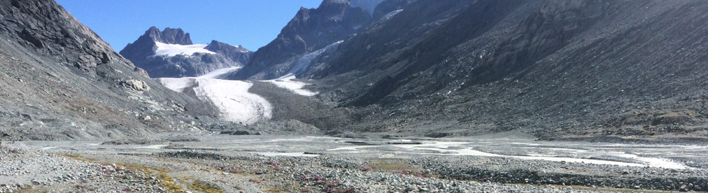
New Paper Published : Subglacial Channels, Climate Warming and Increasing Frequency of Alpine Glacier Snout Collapse
Alpine glacier retreat has increased markedly since the late 1980s and is commonly linked to the effects of rising temperature on the surface melt. Less considered are processes associated with glacier snout-marginal surface collapse. A survey of 22 retreating Swiss glaciers suggests that collapse events have increased in frequency since the early 2000s, driven by ice thinning and reductions in glacier-longitudinal ice flux. Detailed measurement of a collapse event at one glacier showed 0.02 m/day vertical surface deformation above a meandering main subglacial channel. However, with low rates of
longitudinal flux (<1.3 m/year), this was insufficient to close the channel in the snout marginal zone. We hypothesize that an open channel maintains contact between subglacial ice and the atmosphere, allowing greater incursion of warm air up-glacier, thus enhancing melt from below. The associated meandering of subglacial channels at glacier snouts leads to surface collapse and removal of ice via fluvial processes. A copy of the paper is freely available here.
New Paper Published : Evidence of glacier-permafrost interactions associated with hydro-geomorphological processes and landforms at Snøhetta, Dovrefjell, Norway
A paper by Flo Miesen has now been published. Glacier-permafrost interactions are investigated to understand glacial/hydrological influence along a partly glacierised valley on the NE flank of the Snøhetta massif, Dovrefjell, southern Norway. Of particular interest is how processes are controlled by a hydrological connection between landforms. Field mapping identified an ice-marginal landsystem comprising a polythermal glacier, a proglacial lake, an ice-cored moraine complex and a river-lake with perennial frost mounds. A clear interaction between glacial and periglacial processes was observed in transitional landforms, most prominently in the ice-cored moraine which constitutes a permafrost environment that is directly reworked by glacio-fluvial processes. The role of this interaction in controlling seasonal, partial drainage of the proglacial lake was assessed using remote sensing-based observations of lake surface size evolution and seasonal surface subsidence. Results suggest a two-fold threshold for lake drainage: Depending on the dynamics of glacial discharge and active layer depth, the ice-cored moraine may either act as a barrier or a pathway to meltwater exiting the glacier. This demonstrates the importance of meltwater dynamics in controlling landform evolution in a glacial-periglacial landscape. To further assess the importance of surface and subsurface hydrology in linking glacial and periglacial domains, water stable oxygen isotope ratios across the study area were studied to map the flow of meltwater from glacier to permafrost. Results include a model of the surface and subsurface hydrology in the catchment and promote a conceptual understanding of water as a thermal, hydraulic and mechanical agent of transient glacier-permafrost interaction operating at heterogeneous timescales. A copy is available here.
New Paper Published : Dam builders and their works: Beaver influences on the structure and function of river corridor hydrology, geomorphology, biogeochemistry and ecosystems
Beavers (Castor fiber, Castor canadensis) are one of the most influential mammalian ecosystem engineers, heavily modifying river corridor hydrology, geomorphology, nutrient cycling, and ecosystems. As an agent of disturbance, they achieve this first and foremost through dam construction, which impounds flow and increases the extent of open water, and from which all other landscape and ecosystem impacts follow. After a long period of local and regional eradication, beaver populations have been recovering and expanding throughout Europe and North America, as well as an introduced species in South America, prompting a need to comprehensively review the current state of knowledge on how beavers influence the structure and function of river corridors. Here, we synthesize the overall impacts on hydrology, geomorphology, biogeochemistry, and aquatic and terrestrial ecosystems. Our key findings are that a complex of beaver dams can increase surface and subsurface water storage, modify the reach scale partitioning of water budgets, allow site specific flood attenuation, alter low flow hydrology, increase evaporation, increase water and nutrient residence times, increase geomorphic heterogeneity, delay sediment transport, increase carbon, nutrient and sediment storage, expand the extent of anaerobic conditions and interfaces, increase the downstream export of dissolved organic carbon and ammonium, decrease the downstream export of nitrate, increase lotic to lentic habitat transitions and aquatic primary production, induce ‘reverse’ succession in riparian vegetation assemblages, and increase habitat complexity and biodiversity on reach scales. We then examine the key feedbacks and overlaps between these changes caused by beavers, where the decrease in longitudinal hydrologic connectivity create ponds and wetlands, transitions between lentic to lotic ecosystems, increase vertical hydraulic exchange gradients, and biogeochemical cycling per unit stream length, while increased lateral connectivity will determine the extent of open water area and wetland and littoral zone habitats, and induce changes in aquatic and terrestrial ecosystem assemblages. However, the extent of these impacts depends firstly on the hydro-geomorphic landscape context, which determines the extent of floodplain inundation, a key driver of subsequent changes to hydrologic, geomorphic, biogeochemical, and ecosystem dynamics. Secondly, it depends on the length of time beavers can sustain disturbance at a given site, which is constrained by top down (e.g. predation) and bottom up (e.g. competition) feedbacks, and ultimately determines the pathways of river corridor landscape and ecosystem succession following beaver abandonment. This outsized influence of beavers on river corridor processes and feedbacks is also fundamentally distinct from what occurs in their absence. Current river management and restoration practices are therefore open to re-examination in order to account for the impacts of beavers, both positive and negative, such that they can potentially accommodate and enhance the ecosystem engineering services they provide. It is hoped that our synthesis and holistic framework for evaluating beaver impacts can be used in this endeavor by river scientists and managers into the future as beaver populations continue to expand in both numbers and range. A copy is available here.
New Paper Published : Regimes of primary production and their drivers in Alpine streams
Primary production is a fundamental ecosystem process that influences nutrient and carbon cycling, and trophic structure in streams. The magnitude and timing of gross primary production (GPP) are typically controlled by hydrology, light, nutrient availability and grazers. Estimates of GPP and its drivers in high-mountain streams remain elusive at present. We estimated GPP in streams typical for high-mountain catchments, namely a glacier-fed, groundwater-fed (krenal) and a snowmelt-fed (nival) stream. Using high-resolution sensor data over 2 years in combination with numerical simulations of stream hydraulics, we studied the periods of GPP characteristic for these streams, as well as their major drivers. Favourable windows for GPP were constrained to periods at the onset of the snowmelt and its recession, when photosynthetic active radiation at the streambed and streambed stability facilitated GPP. During these windows of opportunity, GPP was higher in the nival stream (3.7 ± 3.4 g O2 m−2 day−1), followed by the glacier-fed (1.5 ± 1.6 g O2 m−2 day−1) and the krenal streams (0.6 ± 0.6 g O2 m−2 day−1). GPP was largely controlled by photosynthetic active radiation at the stream bottom, however, we were not able to establish an unequivocal relationship between flow-induced bed movement and GPP. Our results highlight the capacity of primary producers to exploit the discrete and relatively predictable windows of opportunities in high-mountain streams. We propose that climate-driven change in snow and glacier melt reduction may ameliorate stream environmental conditions, thereby enhancing the potential autochthonous organic matter supply within the catchment. A copy of the paper is available here.
New Paper Published : Sediment yield over glacial cycles: A conceptual model
The temporal variability in sediment export yield from glaciers over a timescale of multiple glacial cycles (e.g. 1 × 10² − 1 × 10⁶ years) is of interest for a wide range of applications in glaciology, sedimentology, geomorphology, climatology and environmental engineering. However, the time required for the products of glacial erosion to be transferred through glaciated catchments and the extent to which glacially-conditioned sediment can be transiently stored within them are still poorly constrained and a matter of debate within the community. We propose a conceptual model of the variability in sediment exported from glaciers over multiple glacial cycles based on a literature review. Sediment yield is likely to be highly variable through a glacial cycle, notably between phases of glacier advance, retreat and re-advance due to changes in ice velocity and erosion rates, ice and meltwater transport capacity, and in glacially-conditioned sediment accessibility at the bed. Typically, early phases of glacier retreat and re-advance are expected to lead to the highest increase in sediment yield due to the ease with which the products of bedrock erosion can be accessed and reworked. In contrast, later phases of glacial (re)advance, once glacially-conditioned sedimentary sources become exhausted, may be characterized by intermediate rates of sediment export yield maintained through bedrock erosion. The latest phases of deglaciation, once glacially-conditioned sedimentary sources are either exhausted, stabilized or disconnected from active processes of sediment transfer, are likely to have the lowest rate of export. The conceptual model proposed in this paper fills a gap in the literature by developing a continuous pattern of sediment yield rate variability over the course of multiple glacial cycles, with wider implications for future research. However, its systematic applicability to various glacier settings and glaciations needs more field and modeling data to validate it.
The paper is published in the journal Progress in Physical Geography and a copy of this paper is freely available here.
New Paper Published : Quantifying the spatial distribution of sediment transport in an experimental gully system using the morphological method
Whilst time‐series of sediment transport in gullies in both laboratory experimental and field settings can be determined through instrumentation, quantifying the spatial distribution of transport rates remains challenging. The morphological method, which was proposed for estimating bed‐material transport in both one‐ and two‐dimensions in rivers, provides an alternative. Here, we developed this method for gully systems. A laboratory catchment was used to simulate gully erosion. High‐resolution topographical data were acquired by close‐range digital photogrammetry. Morphological changes were determined using high‐resolution topographic data and an associated level of detection. Based on measured morphological changes, one‐dimensional (1D) and two‐dimensional (2D) sediment transport rates were calculated via cross‐section by cross‐section routing (1D) and cell by cell routing (2D). The 1D application provided a general trend of longitudinal variation of sediment transport for the whole gully system, increased gradually from zones of headward extension to a zone downstream where erosion and deposition were in balance, and sediment transport rates less variable in space. For the 2D application, hydrological and blended hydrological‐hydraulic routing solutions were compared. We found that the level of negative transport was insensitive to whether or not a blended hydrological‐hydraulic routing was used and that results from applying the hydrological routing throughout were not significantly degraded. We also found that consideration should be given to spatial and temporal resolution of the topographic data. The 2D application provided spatial patterns of sediment transport that vary with gully evolution. The main gully remained a high transport corridor but branch transport became more important through time. The framework we report provides an additional tool for both experimental and field quantification of the spatial patterns of sediment transport in gullies; and quantification of how these patterns change under different forcing factors.
A copy of the paper is available here.