Loess landform variability across large spatial extents needs to be analyzed to understand the formation and evolution of loess landscapes. This is becoming increasingly possible via the automated analysis of remotely-sensed data. Here, we quantify loess landforms using an object-based image analysis (OBIA) method and use this classification to describe the spatial variability of loess landforms. Quantitative indicators are used to drive the spatial variability analysis of loess landforms and explain their spatio-temporal evolution. Moreover, the hypsometric integral (HI) and topographic interpolation are employed to investigate soil erosion and development patterns of loess landscape. Results show that the OBIA method classified loess landforms to an accuracy of 88.7 %. The derived metrics in terms of the area, slope and complexity of landform shape allow the determination of the spatial structure of the loess landscapes. The HI value of the entire basin is 0.486, representing the mature stage of landform development, with relatively severe surface erosion. Correlation analysis of HI values and related indicators in the sub-basins shows that HI is poorly correlated with the area proportion of loess landform types and the total erosion volume in the basin but shows a relatively strong correlation with the volume of erosion per unit area. A link to the paper is here.
New Paper Published : Spatial patterns of benthic biofilm diversity among streams draining proglacial floodplains
Glacier shrinkage opens new proglacial terrain with pronounced environmental gradients along longitudinal and lateral chronosequences. Despite the environmental harshness of the streams that drain glacier forelands, their benthic biofilms can harbor astonishing biodiversity spanning all domains of life. Here, we studied the spatial dynamics of prokaryotic and eukaryotic photoautotroph diversity within braided glacier-fed streams and tributaries draining lateral terraces predominantly fed by groundwater and snowmelt across three proglacial floodplains in the Swiss Alps. Along the lateral chronosequence, we found that benthic biofilms in tributaries develop higher biomass than those in glacier-fed streams, and that their respective diversity and community composition differed markedly. We also found spatial turnover of bacterial communities in the glacier-fed streams along the longitudinal chronosequence. These patterns along the two chronosequences seem unexpected given the close spatial proximity and connectivity of the various streams, suggesting environmental filtering as an underlying mechanism. Furthermore, our results suggest that photoautotrophic communities shape bacterial communities across the various streams, which is understandable given that algae are the major source of organic matter in proglacial streams. Overall, our findings shed new light on benthic biofilms in proglacial streams now changing at rapid pace owing to climate-induced glacier shrinkage. A copy of the paper is freely available here.
New Paper Published : High Mountain Asia hydropower systems threatened by climate-driven landscape instability
Global warming-induced melting and thawing of the cryosphere are severely altering the volume and timing of water supplied from High Mountain Asia, adversely affecting downstream food and energy systems that are relied on by billions of people. The construction of more reservoirs designed to regulate streamflow and produce hydropower is a critical part of strategies for adapting to these changes. However, these projects are vulnerable to a complex set of interacting processes that are destabilizing landscapes throughout the region. Ranging in severity and the pace of change, these processes include glacial retreat and detachments, permafrost thaw and associated landslides, rock–ice avalanches, debris flows and outburst floods from glacial lakes and landslide-dammed lakes. The result is large amounts of sediment being mobilized that can fill up reservoirs, cause dam failure and degrade power turbines. Here we recommend forward-looking design and maintenance measures and sustainable sediment management solutions that can help transition towards climate change-resilient dams and reservoirs in High Mountain Asia, in large part based on improved monitoring and prediction of compound and cascading hazards. A link to the paper is available here.
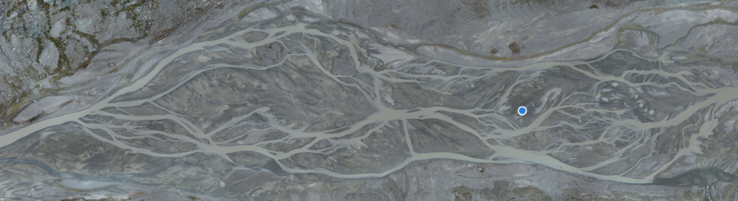
New Paper Published : Centimeter-scale mapping of phototrophic biofilms in glacial forefields using visible band ratios and UAV imagery
Microbial biofilms have received great attention in the last few decades from both aquatic ecologists and biogeomorphologists. Most recently, this has focused on mapping biofilms to understand their spatial distributions and ecosystem services. Such studies often involve the use of satellite imagery, which typically provides large temporal and spatial scales and wide-range spectral information. Although satellites have the advantage of multi- and hyper-spectral sensors, images often have low spatial resolution that limits their use in river studies, where both rivers are narrower and stream processes occur at resolutions smaller than the footprint of satellite sensors. Spatial resolution is sensor quality dependent but also controlled by sensor elevation above the ground. Hence, high resolutions can be achieved either by using a very expensive sensor or by decreasing the distance between the target area and the sensor itself. To date, sensor technology has advanced to a point where multi- or even hyper-spectral cameras can be easily carried out by an Uncrewed Aerial Vehicle (UAV) at unprecedented spatial resolutions. Where such sensors have high spectral resolution, they are often prohibitively expensive, especially as their use in extreme environments such as glacial forefields risks UAV damage. In this paper, we test the performance of visible band ratios in mapping biofilms in an Alpine glacier forefield characterized by a well-developed and heterogeneous stream ecosystem but using a low-cost UAV. The paper shows that low-cost and consumer grade UAVs can be easily deployed in such extreme environments, delivering both quality RGB images for photogrammetric (SfM-MVS) processing and sufficient spectral information for benthic biofilm mapping at high temporal and spatial resolution. A copy id freely available here.
New Paper Published : Improving the Calibration of the Swiss Plate Geophone Bedload Monitoring System by Filtering Out Seismic Signals From Extraneous Particle Impacts
The spatio-temporal variability of bedload transport processes poses considerable challenges for bedload monitoring systems. One such system, the Swiss plate geophone (SPG), has been calibrated in several gravel-bed streams using direct sampling techniques. The linear calibration coefficients linking the signal recorded by the SPG system to the transported bedload can vary between different monitoring stations by about a factor of six, for reasons that remain unclear. Recent controlled flume experiments allowed us to identify the grain-size distribution of the transported bedload as a further site-specific factor influencing the signal response of the SPG system, along with the flow velocity and the bed roughness. Additionally, impact tests performed at various field sites suggested that seismic waves generated by impacting particles can propagate over several plates of an SPG array, and thus potentially bias the bedload estimates. To gain an understanding of this phenomenon, we adapted a test flume by installing a partition wall to shield individual sensor plates from impacting particles. We show that the SPG system is sensitive to seismic waves that propagate from particle impacts on neighboring plates or on the concrete bed close to the sensors despite isolating elements. Based on this knowledge, we designed a filter method that uses time-frequency information to identify and eliminate these “apparent” impacts. Finally, we apply the filter to four field calibration datasets and show that it significantly reduces site-to-site differences between calibration coefficients and enables the derivation of a single calibration curve for total bedload at all four sites. A copy is freely available here.
New Paper Published : Hydrological drivers of bedload transport in an Alpine watershed
Understanding and predicting bedload transport is an important element of watershed management. Yet, predictions of bedload remain uncertain by up to several order(s) of magnitude. In this contribution, we use a five-year continuous time-series of streamflow and bedload transport monitoring in a 13.4 km2 snow-dominated Alpine watershed in the Western Swiss Alps to investigate hydrological drivers of bedload transport. Following a calibration of the bedload sensors, and a quantification of the hydraulic forcing of streamflow upon bedload, a hydrological analysis is performed to identify daily flow hydrographs influenced by different hydrological drivers: rainfall, snowmelt, and combined rain and snowmelt events. We then quantify their respective contribution to bedload transport. Results emphasize the importance of combined rain and snowmelt events, for both annual bedload volumes (77% on average) and peaks in bedload transport rate. A non-negligible, but smaller, amount of bedload transport may occur during late summer and autumn storms, once the snowmelt contribution and baseflow have significantly decreased (9% of the annual volume on average). Although rainfall-driven changes in flow hydrographs are responsible for a large majority of the annual bedload volumes (86% on average), the identified melt-only events also represent a substantial contribution (14% on average). The results of this study help to improve current predictions of bedload transport through a better understanding of the bedload magnitude-frequency relationship under different hydrological conditions. We further discuss how bedload transport could evolve under a changing climate through its effects on Alpine watershed hydrology. A copy is freely available here.
New Paper Published : Bedload transport: Are we doing restoration right in the face of alpine climate change?
Alpine landscapes are undergoing climate warming at a higher rate than other regions of the world. The current and future impacts of this warming on the cryosphere (snow and ice) and their implications for stream flows are now well known and there exist predictions of how snow, ice and river flows are likely to evolve in Alpine environments over the 21st century (e.g. [1, 2, 3]). There is no doubt that such changes will also impact bedload transport in Alpine streams. Bedload transport in many Alpine streams is, however, also impacted significantly by the direct effects of human activities such as hydropower and gravel extraction (e.g. [4, 5]). These direct effect have dominated the concerns of bedload management or river restoration over the last decade or more. It is therefore a logical question to ask whether or not river restoration projects and the bedload management policies thought necessary to support them needs to adapt in the face of climate change. The lead in time to many policy solutions for bedload management, especially those involving new infrastructure, is not negligible. Given the current rate of warming in Alpine environments, higher than many non-Alpine regions [6], climate change sensitive bedload management may already be needed. However, the target of river restoration should not be bedload transport itself but rather the societal ecosystem services that are sustained by the consequences of bedload transport. This may be in terms of the right level of sediment evacuation to stop bed level rise during a flood that can lead to catastrophic loss of property and even life; or the gravel sized sediment that spawning salmonids need during the late autumn of each year; as examples of a wider set of services that rivers provide. Simply developing a bedload management policy to be climate sensitive is not enough; the focus has to be on the consequences of such policy for erosion, deposition, grainsize, river morphodynamics etc. These need to be evaluated at the scale of a river basin and so also need to recognize the basic challenges posed by sediment continuity; a policy decision to increase or to decrease bedload transport locally will have downstream consequences that may be either positive or negative. Communities and ecosystems downstream, may have already become accustomed to a certain bedload transport regime and this further complicates the problem. In this paper, we seek to answer six broad questions that should be part of a sustainable bedload management policy in Alpine environments in the light of climate change:
I. What must we be capable of predicting?
II. Is there a bedload transport “hockey stick” in Alpine streams?
III. Can we predict bedload transport rates now with sufficient precision and accuracy for them to be usable in predictions of the future?
IV. How might bedload transport capacity change in the future in Alpine basins?
V. How might sediment supply change in the future in Alpine basins?
VI. So, are we doing restoration right in the light of Alpine climate change?
A copy of the paper can be freely downloaded here.
New Paper Published : Restoring morphodynamics downstream from Alpine dams: Development of a geomorphological version of the serial discontinuity concept
There is well-established evidence that dams disconnect upstream to downstream sediment flux in rivers and that this may have negative impact on downstream ecosystems. For this reason, the development of environmental flows now includes sediment supply and transport whether through reconnecting upstream supplied sediment to a river downstream of a dam, eco-morphogenic flows to rework the stream bed, or artificial sediment supply. However, especially in Alpine systems, there may be unregulated tributaries that are able to deliver gravel and coarser sediment naturally to compensate for the effects of dam-related sediment disconnection. To represent these effects we propose a geomorphic form of the serial discontinuity concept and apply it to two hydropower dam-impacted Alpine streams in the Swiss Pennine Alps. Conceptually, the relative position of a dam influences the degree of coarse sediment disconnection as well as the rate of coarse sediment recovery, especially as many Alpine valleys have strong down-valley gradients in tributary sediment delivery. In both case-studies, there was rapid recovery in likely coarse sediment delivery downstream of the dams. By following geomorphic response of the rivers to eco-morphogenic flow trials, proposed as a solution to perceived dam-driven coarse-sediment disconnection, we confirmed that both rivers are likely to have more than sufficient natural coarse sediment supply and unregulated floods. Natural coarse sediment supply is rarely considered in the management of Alpine streams impacted by hydropower but it needs to be evaluated through a geomorphological assessment, considering both the geomorphic context of the river reaches downstream of the dam and the geomorphic attributes of the basin in which the dam is found. A copy is freely available here.
New Paper Published : Subglacial Channels, Climate Warming and Increasing Frequency of Alpine Glacier Snout Collapse
Alpine glacier retreat has increased markedly since the late 1980s and is commonly linked to the effects of rising temperature on the surface melt. Less considered are processes associated with glacier snout-marginal surface collapse. A survey of 22 retreating Swiss glaciers suggests that collapse events have increased in frequency since the early 2000s, driven by ice thinning and reductions in glacier-longitudinal ice flux. Detailed measurement of a collapse event at one glacier showed 0.02 m/day vertical surface deformation above a meandering main subglacial channel. However, with low rates of
longitudinal flux (<1.3 m/year), this was insufficient to close the channel in the snout marginal zone. We hypothesize that an open channel maintains contact between subglacial ice and the atmosphere, allowing greater incursion of warm air up-glacier, thus enhancing melt from below. The associated meandering of subglacial channels at glacier snouts leads to surface collapse and removal of ice via fluvial processes. A copy of the paper is freely available here.
New Paper Published : Evidence of glacier-permafrost interactions associated with hydro-geomorphological processes and landforms at Snøhetta, Dovrefjell, Norway
A paper by Flo Miesen has now been published. Glacier-permafrost interactions are investigated to understand glacial/hydrological influence along a partly glacierised valley on the NE flank of the Snøhetta massif, Dovrefjell, southern Norway. Of particular interest is how processes are controlled by a hydrological connection between landforms. Field mapping identified an ice-marginal landsystem comprising a polythermal glacier, a proglacial lake, an ice-cored moraine complex and a river-lake with perennial frost mounds. A clear interaction between glacial and periglacial processes was observed in transitional landforms, most prominently in the ice-cored moraine which constitutes a permafrost environment that is directly reworked by glacio-fluvial processes. The role of this interaction in controlling seasonal, partial drainage of the proglacial lake was assessed using remote sensing-based observations of lake surface size evolution and seasonal surface subsidence. Results suggest a two-fold threshold for lake drainage: Depending on the dynamics of glacial discharge and active layer depth, the ice-cored moraine may either act as a barrier or a pathway to meltwater exiting the glacier. This demonstrates the importance of meltwater dynamics in controlling landform evolution in a glacial-periglacial landscape. To further assess the importance of surface and subsurface hydrology in linking glacial and periglacial domains, water stable oxygen isotope ratios across the study area were studied to map the flow of meltwater from glacier to permafrost. Results include a model of the surface and subsurface hydrology in the catchment and promote a conceptual understanding of water as a thermal, hydraulic and mechanical agent of transient glacier-permafrost interaction operating at heterogeneous timescales. A copy is available here.