Stream periphytons are candidate ecosystem engineers in proglacial margins. Here, we quantify the extent to which they are engineers for the case of hillslope-fed tributaries in the terrace zones of proglacial margin alluvial plains. Candidate ecosystem engineering effects relate to periphyton-driven changes in (1) vertical infiltration of water, which in turn could aid plant colonization and hence local surface stabilization, and (2) near-bed hydraulics, notably near-bed turbulence properties. We ran two flume experiments in parallel in the proglacial margin of the Otemma glacier (Switzerland), reproducing the environmental conditions found in terrace streams. In both experiments, we followed periphyton development on initially bare sediments for 28 days. Then, whilst the experiment continued undisturbed in one flume, in the second and over a further 26 days, we introduced disturbances in the form of desiccation events. Throughout the entire experiment length, we collected imagery for close-range SfM-MVS photogrammetry, data on vertical infiltration, and near-bed hydraulics. The experiments showed that periphyton development significantly changed the streambed properties. First, periphyton development over the timescale of a few days reduced bed roughness and clogged the benthic interstitial space, reducing water infiltration. These effects were insensitive to the disturbance regime. Second, the changes in streambed roughness modified the near-bed turbulent structures, and this resulted in a reduction of bursting events and in the modification of the turbulent kinetic energy at the near-bed layer. The latter, however, appeared to be less important in these environments as compared with the impacts on infiltration. Given the low water retaining capacity of glacial sediments, the observation that periphyton can reduce vertical infiltration explains wider observations of their importance in glacial floodplains where vegetation succession is critically constrained by water availability. The relatively reduced impacts on near-bed turbulence also contribute to explaining why disturbance in proglacial margin streams remains a key limit on ecological succession. A copy is freely available here.
New Paper Published : Current and future roles of meltwater–groundwater dynamics in a proglacial Alpine outwash plain
Glacierized alpine catchments are rapidly evolving due to glacier retreat and consequent geomorphological and ecological changes. As more terrain becomes ice-free, reworking of exposed terrain by the river as well as thawing of the top layer may lead to an increase in surface and subsurface water exchanges, leading to potential changes in water storage and release, which in turn may impact ecological, geomorphological and hydrological processes. In this study, we aim to understand the current and future hydrological functioning of a typical outwash plain in a Swiss Alpine catchment. As with many other fluvial aquifers in alpine environments, this outwash plain is located at the valley bottom, where catchment-wide water and sediment fluxes tend to gather from multiple sources, may store water and provide specific habitats for alpine ecosystems. Their dynamics are however rarely studied in post Little Ice Age proglacial zones. Based on geophysical investigations as well as year-round stream and groundwater observations, we developed a simplified physically based 3D MODFLOW model and performed an optimized automatic calibration using PEST HP. We highlight the strong interactions between the upstream river and the aquifer, with stream infiltration being the dominant process of recharge. Groundwater exfiltration occurs in the lower half of the outwash plain, balancing out the amount of river infiltration at a daily timescale. We show that hillslope contributions from rain and snowmelt have little impact on groundwater levels. We also show that the outwash plain acts as a bedrock-dammed aquifer and can maintain groundwater levels close to the surface during dry periods lasting months, even in the absence of glacier meltwater, but may in turn provide only limited baseflow to the stream. Finally, we explore how new outwash plains may form in the future in this catchment due to glacier recession and discuss from a hydrological perspective which cascading impacts the presence of multiple outwash plains may have. For this case study, we estimate the total dynamic storage of future outwash plains to be about 20 mm, and we demonstrate their limited capacity to provide more stream water than that which they infiltrate upstream, except for very low river flows (<150 to 200 L s−1). Below this limit, they can provide limited baseflow on timescales of weeks, thus maintaining moisture conditions that may be beneficial for proglacial ecosystems. Their role in attenuating floods also appears limited, as less than 0.5 m3 s−1 of river water can be infiltrated. The studied outwash plain appears therefore to play an important role for alpine ecosystems but has a marginal hydrological effect on downstream river discharge. A copy is freely available here.
New Paper Published : Tree-ring hydrological research in the Himalaya: State of the art and future directions
Recent developments in tree-ring research offer great potential for reconstructing past climate changes; determining the frequencies of natural hazards; and assessing the availability of freshwater resources over timescales that extend well into the pre-instrumental period. Here, we review the state of dendrochronological research in the Himalaya and outline future directions for tree-ring-based hydrological reconstructions in a region that has a pressing societal need to understand the causes and consequences of past, present and future changes in the hydrological cycle. We used ‘tree ring’ and ‘Himalaya’ as keywords to identify scholarly articles from the Web of Science that were published between 1994 and 2022. The resulting 173 publications were separated by their spatial coverage into the western, central and eastern Himalaya, as well as their scientific purpose (e.g. reconstructing growth-climate relationships, temperature, precipitation, streamflow, floods, droughts, etc.). Our analysis shows that dendrochronological research in the Himalaya primarily focused on understanding growth-climate relationships using annual tree-ring widths measurements obtained for coniferous species, and their application in climate reconstructions. Reconstructions of hydrological processes such as streamflows, and extremes such as glacial and landslide lake outburst floods, have received less attention. Recent advances in dendrochronology, including blue intensity (BI), quantitative wood anatomy (QWA), and tree-ring stable isotopes (TRSI) should be combined to improve the resolution and accuracy of hydrological reconstructions in all parts of the Himalaya. Such studies may allow us to better understand the effects of climate change and the Himalayan water resources for its lowland surroundings. They may also facilitate decision-making processes for mitigating the impacts of climate change on natural hazards, and for better managing water resources in the region. A copy is freely available here.
New Paper Published : Cross-domain interactions confer stability to benthic biofilms in proglacial streams
Cross-domain interactions are an integral part of the success of biofilms in natural environments but remain poorly understood. Here, we describe cross-domain interactions in stream biofilms draining proglacial floodplains in the Swiss Alps. These streams, as a consequence of the retreat of glaciers, are characterised by multiple environmental gradients and perturbations (e.g., changes in channel geomorphology, discharge) that depend on the time since deglaciation. We evaluate co-occurrence of bacteria and eukaryotic communities along streams and show that key community members have disproportionate effects on the stability of community networks. The topology of the networks, here quantified as the arrangement of the constituent nodes formed by specific taxa, was independent of stream type and their apparent environmental stability. However, network stability against fragmentation was higher in the streams draining proglacial terrain that was more recently deglaciated. We find that bacteria, eukaryotic photoautotrophs, and fungi are central to the stability of these networks, which fragment upon the removal of both pro- and eukaryotic taxa. Key taxa are not always abundant, suggesting an underlying functional component to their contributions. Thus, we show that there is a key role played by individual taxa in determining microbial community stability of glacier-fed streams. A copy is freely available here.
Prix Schläfli 2024 awarded to Gilles Antoniazza
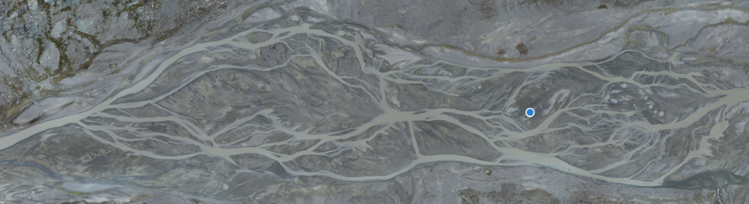
New Paper Published : Filtering of the Signal of Sediment Export From a Glacier by Its Proglacial Forefield
Alpine glaciers are rapidly retreating due to global warming and this has been associated with enhanced supply of subglacially derived sediment to downstream environments. We present the first high frequency quantitative record on how the signal of sediment exported from an Alpine glacier is filtered by its proglacial forefield. The data, covering two climatically distinct glacier melt seasons, show that the signal of subglacial bedload export is strongly filtered over short distances, unlike suspended load whose signal is less impacted. The reason is related to the interplay of short particle advection lengths with strong morphodynamic forcing. The subglacial sediment export signal is thus rapidly replaced by one combining (a) the local forcing by stream hydraulics and (b) the reworking of the proglacial braid plain itself. These findings have implications for estimating subglacial erosion rates, natural hazard mitigation, sediment management for hydropower plants and ecological succession related to rapid glacier retreat. A copy is freely available here.
New Paper Published : Hydrological heterogeneity and the plant colonization of recently deglaciated terrain
Climate change accelerates glacier retreat, leading to extensive exposure of sediment to light and ecological succession. Succession has traditionally been studied as a chronosequence, where vegetation development is directly correlated with time since glacier retreat or distance from the retreating glacier margin. More recent work has challenged this model, arguing that succession seems to be mainly influenced by heterogeneous conditions at the local scale. The aim of this study was to identify the factors influencing the local-scale establishment of plant communities following glacier recession. Vascular plants and their cover were inventoried in 100 plots (1 m2) for a thirty-year-old alluvial plain in front of the Otemma glacier (Swiss Alps). Depth to water table, distance to the glacial main river and to the nearest channel, sediment size, moss, lichen, and biological soil crust cover were measured. Results showed that proglacial margins develop hydrological heterogeneity over a small scale, reflected in the four observed plant communities. These range from the dry Sempervivum-dominated community, on gravel-rich sediments with a deep water table, to the Trifolium-dominated community, close to secondary channels, with the highest plant cover and species richness and incorporating grassland species. Heterogeneity in water availability exerted a critical control on vegetation development. A copy of the paper is freely available here.
New Paper Published : Tracking coarse sediment in an Alpine subglacial channel using radio-tagged particles
We present a method for tracking radio-tagged pebbles and cobbles through subglacial meltwater channels under shallow temperate glaciers. Natural particles tagged with active radio transmitters were injected directly into a large subglacial channel 300 m up-glacier from the terminus of the Glacier d’Otemma, Switzerland. A roving antenna was developed to localise tagged particles planimetrically in subglacial and proglacial channel reaches (350 and 150 m long, respectively) using a probabilistic technique, delivering records of the change in particle location and transport distance over time with uncertainty. The roving antenna had a ±5−15 m planimetric precision, a 75% particle localisation rate and operated at a maximum ice depth of 47 m. Additionally, stationary supraglacial and proglacial antennas continuously monitored the passage of tagged particles through consecutive reaches of the channel, constraining the timing of particle transport events. The proglacial antenna system had a 98.1% detection rate and was operational to 0.89 m water depth during testing. Roving and stationary antenna records were combined to create a transport distance model for each particle, which may be used in conjunction with hydraulic data to investigate the kinematics of particle motion. When applied at scale in future studies, this method may be used to reveal the mechanisms and timescales of coarse sediment export from Alpine glaciers. A copy of the paper is freely available here.
New Paper Published : Ecosystem engineering by periphyton in Alpine proglacial stream
Stream periphytons are candidate ecosystem engineers in proglacial margins. Here, we quantify the extent to which they are engineers for the case of hillslope-fed tributaries in the terrace zones of proglacial margin alluvial plains. Candidate ecosystem engineering effects relate to periphyton-driven changes in (1) vertical infiltration of water, which in turn could aid plant colonization and hence local surface stabilization, and (2) near-bed hydraulics, notably near-bed turbulence properties. We ran two flume experiments in parallel in the proglacial margin of the Otemma glacier (Switzerland), reproducing the environmental conditions found in terrace streams. In both experiments, we followed periphyton development on initially bare sediments for 28 days. Then, whilst the experiment continued undisturbed in one flume, in the second and over a further 26 days, we introduced disturbances in the form of desiccation events. Throughout the entire experiment length, we collected imagery for close-range SfM-MVS photogrammetry, data on vertical infiltration, and near-bed hydraulics. The experiments showed that periphyton development significantly changed the streambed properties. First, periphyton development over the timescale of a few days reduced bed roughness and clogged the benthic interstitial space, reducing water infiltration. These effects were insensitive to the disturbance regime. Second, the changes in streambed roughness modified the near-bed turbulent structures, and this resulted in a reduction of bursting events and in the modification of the turbulent kinetic energy at the near-bed layer. The latter, however, appeared to be less important in these environments as compared with the impacts on infiltration. Given the low water retaining capacity of glacial sediments, the observation that periphyton can reduce vertical infiltration explains wider observations of their importance in glacial floodplains where vegetation succession is critically constrained by water availability. The relatively reduced impacts on near-bed turbulence also contribute to explaining why disturbance in proglacial margin streams remains a key limit on ecological succession. A copy is freely available here.
New Paper Published : Improving UAV-SfM photogrammetry for modelling high-relief terrain: Image collection strategies and ground control quantity
Image collection strategies and ground control points (GCPs) are of particular importance for uncrewed aerial vehicle combined with Structure-from-Motion (UAV–SfM) photogrammetry, and the generalization of their effects has proved elusive. This study designed various photogrammetric scenarios to investigate the effects of image collection strategies, ground control quantity, and their interaction on digital elevation model (DEM) errors and their spatial structure in high-relief terrain. The results of 1.77 × 10⁵ UAV–SfM scenarios provide insights for improving UAV–SfM practices. A high image capture angle (20–40°) enhances camera calibration quality decreasing the magnitude and spatial correlation of errors. High camera inclination reduces the sensitivity of mean and standard deviation of error to flying height but not the spatial correlation of error. Including additional data (e.g. supplemented convergent images; images captured at multiple flying heights) has only a minor effect if imagery is highly inclined. GCPs provide more effective constraints than image collection strategies. The mean error and standard error decline quickly with a small number of GCPs and then become stable in all scenarios, but the spatial correlation of error can be further improved with increasing GCPs. However, the effects of GCP quantity do interact with image collection strategies. High camera inclination reduces requirements for GCPs, whilst strategies combining different flying heights and image orientations have little effect on necessary GCP quantity. The distribution of GCPs still affects the errors, but the effect of GCP distribution becomes less important with an increase in the number of GCPs. Finally, we show that UAV–SfM photogrammetric quality assessment should routinely assess the spatial dependence of error using a statistic like Moran’s I. The paper is available here or a copy can be obtained by emailing stuart.lane@unil.ch.