Congratulations to Gilles Antoniazza has been awarded the Prix Schläfli for 2024 by the Swiss Academy of Sciences, one of the oldest academic prizes in Switzerland, first given in 1866. His citation is here. You can also read more here about his work.
New Paper Published : Filtering of the Signal of Sediment Export From a Glacier by Its Proglacial Forefield
Alpine glaciers are rapidly retreating due to global warming and this has been associated with enhanced supply of subglacially derived sediment to downstream environments. We present the first high frequency quantitative record on how the signal of sediment exported from an Alpine glacier is filtered by its proglacial forefield. The data, covering two climatically distinct glacier melt seasons, show that the signal of subglacial bedload export is strongly filtered over short distances, unlike suspended load whose signal is less impacted. The reason is related to the interplay of short particle advection lengths with strong morphodynamic forcing. The subglacial sediment export signal is thus rapidly replaced by one combining (a) the local forcing by stream hydraulics and (b) the reworking of the proglacial braid plain itself. These findings have implications for estimating subglacial erosion rates, natural hazard mitigation, sediment management for hydropower plants and ecological succession related to rapid glacier retreat. A copy is freely available here.
New Paper Published : Hydrological heterogeneity and the plant colonization of recently deglaciated terrain
Climate change accelerates glacier retreat, leading to extensive exposure of sediment to light and ecological succession. Succession has traditionally been studied as a chronosequence, where vegetation development is directly correlated with time since glacier retreat or distance from the retreating glacier margin. More recent work has challenged this model, arguing that succession seems to be mainly influenced by heterogeneous conditions at the local scale. The aim of this study was to identify the factors influencing the local-scale establishment of plant communities following glacier recession. Vascular plants and their cover were inventoried in 100 plots (1 m2) for a thirty-year-old alluvial plain in front of the Otemma glacier (Swiss Alps). Depth to water table, distance to the glacial main river and to the nearest channel, sediment size, moss, lichen, and biological soil crust cover were measured. Results showed that proglacial margins develop hydrological heterogeneity over a small scale, reflected in the four observed plant communities. These range from the dry Sempervivum-dominated community, on gravel-rich sediments with a deep water table, to the Trifolium-dominated community, close to secondary channels, with the highest plant cover and species richness and incorporating grassland species. Heterogeneity in water availability exerted a critical control on vegetation development. A copy of the paper is freely available here.
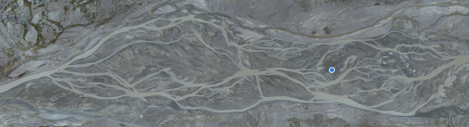
New Paper Published : Tracking coarse sediment in an Alpine subglacial channel using radio-tagged particles
We present a method for tracking radio-tagged pebbles and cobbles through subglacial meltwater channels under shallow temperate glaciers. Natural particles tagged with active radio transmitters were injected directly into a large subglacial channel 300 m up-glacier from the terminus of the Glacier d’Otemma, Switzerland. A roving antenna was developed to localise tagged particles planimetrically in subglacial and proglacial channel reaches (350 and 150 m long, respectively) using a probabilistic technique, delivering records of the change in particle location and transport distance over time with uncertainty. The roving antenna had a ±5−15 m planimetric precision, a 75% particle localisation rate and operated at a maximum ice depth of 47 m. Additionally, stationary supraglacial and proglacial antennas continuously monitored the passage of tagged particles through consecutive reaches of the channel, constraining the timing of particle transport events. The proglacial antenna system had a 98.1% detection rate and was operational to 0.89 m water depth during testing. Roving and stationary antenna records were combined to create a transport distance model for each particle, which may be used in conjunction with hydraulic data to investigate the kinematics of particle motion. When applied at scale in future studies, this method may be used to reveal the mechanisms and timescales of coarse sediment export from Alpine glaciers. A copy of the paper is freely available here.
New Paper Published : Ecosystem engineering by periphyton in Alpine proglacial stream
Stream periphytons are candidate ecosystem engineers in proglacial margins. Here, we quantify the extent to which they are engineers for the case of hillslope-fed tributaries in the terrace zones of proglacial margin alluvial plains. Candidate ecosystem engineering effects relate to periphyton-driven changes in (1) vertical infiltration of water, which in turn could aid plant colonization and hence local surface stabilization, and (2) near-bed hydraulics, notably near-bed turbulence properties. We ran two flume experiments in parallel in the proglacial margin of the Otemma glacier (Switzerland), reproducing the environmental conditions found in terrace streams. In both experiments, we followed periphyton development on initially bare sediments for 28 days. Then, whilst the experiment continued undisturbed in one flume, in the second and over a further 26 days, we introduced disturbances in the form of desiccation events. Throughout the entire experiment length, we collected imagery for close-range SfM-MVS photogrammetry, data on vertical infiltration, and near-bed hydraulics. The experiments showed that periphyton development significantly changed the streambed properties. First, periphyton development over the timescale of a few days reduced bed roughness and clogged the benthic interstitial space, reducing water infiltration. These effects were insensitive to the disturbance regime. Second, the changes in streambed roughness modified the near-bed turbulent structures, and this resulted in a reduction of bursting events and in the modification of the turbulent kinetic energy at the near-bed layer. The latter, however, appeared to be less important in these environments as compared with the impacts on infiltration. Given the low water retaining capacity of glacial sediments, the observation that periphyton can reduce vertical infiltration explains wider observations of their importance in glacial floodplains where vegetation succession is critically constrained by water availability. The relatively reduced impacts on near-bed turbulence also contribute to explaining why disturbance in proglacial margin streams remains a key limit on ecological succession. A copy is freely available here.
New Paper Published : Improving UAV-SfM photogrammetry for modelling high-relief terrain: Image collection strategies and ground control quantity
Image collection strategies and ground control points (GCPs) are of particular importance for uncrewed aerial vehicle combined with Structure-from-Motion (UAV–SfM) photogrammetry, and the generalization of their effects has proved elusive. This study designed various photogrammetric scenarios to investigate the effects of image collection strategies, ground control quantity, and their interaction on digital elevation model (DEM) errors and their spatial structure in high-relief terrain. The results of 1.77 × 10⁵ UAV–SfM scenarios provide insights for improving UAV–SfM practices. A high image capture angle (20–40°) enhances camera calibration quality decreasing the magnitude and spatial correlation of errors. High camera inclination reduces the sensitivity of mean and standard deviation of error to flying height but not the spatial correlation of error. Including additional data (e.g. supplemented convergent images; images captured at multiple flying heights) has only a minor effect if imagery is highly inclined. GCPs provide more effective constraints than image collection strategies. The mean error and standard error decline quickly with a small number of GCPs and then become stable in all scenarios, but the spatial correlation of error can be further improved with increasing GCPs. However, the effects of GCP quantity do interact with image collection strategies. High camera inclination reduces requirements for GCPs, whilst strategies combining different flying heights and image orientations have little effect on necessary GCP quantity. The distribution of GCPs still affects the errors, but the effect of GCP distribution becomes less important with an increase in the number of GCPs. Finally, we show that UAV–SfM photogrammetric quality assessment should routinely assess the spatial dependence of error using a statistic like Moran’s I. The paper is available here or a copy can be obtained by emailing stuart.lane@unil.ch.
New Paper Published : Anatomy of an Alpine Bedload Transport Event: A Watershed-Scale Seismic-Network Perspective
The way Alpine rivers mobilize, convey and store coarse material during high-magnitude events is poorly understood, notably because it is difficult to obtain measurements of bedload transport at the watershed scale. Seismic sensor data, evaluated with appropriate seismic physical models, can provide that missing link by yielding time-varying estimates of bedload transport albeit with non-negligible uncertainty. Low cost and ease of installation allow for networks of sensors to be deployed, providing continuous, watershed-scale insights into bedload transport dynamics. Here, we deploy a network of 24 seismic sensors to estimate coarse material fluxes in a 13.4 km2 Alpine watershed during a high-magnitude transport event. First, we benchmark the seismic inversion routine with an independent time-series of bedload transport obtained with a calibrated acoustic system. Then, we apply the procedure to the other seismic sensors across the watershed. Propagation velocities derived from cross-correlation analysis between spatially consecutive bedload transport time-series were too high with respect to typical bedload transport velocity suggesting that a faster-moving water wave (re-)mobilizes local coarse material. Spatially distributed estimates of bedload transport reveal a relative inefficiency of Alpine watersheds in evacuating coarse material, even during a relatively infrequent high-magnitude bedload transport event. Significant inputs estimated for some tributaries were rapidly attenuated as the main river crossed less hydraulically efficient reaches. Only a small proportion of the total amount of material mobilized in the watershed was exported at the outlet. Multiple periods of competent flows are likely necessary to evacuate coarse material mobilized throughout the watershed during individual bedload transport events. The paper is freely available here and was also the topic of an EOS Spotlight here.
New Paper Published : Patterns and drivers of glacier debris-cover development in the Afghanistan Hindu Kush HimalayaNew Paper Published :
Debris-covered ice is widespread in mountain regions with debris an important control on surface ice melt and glacier retreat. Quantifying debris cover extent and its evolution through time over large regions remains a challenge. This study develops two Normalized Difference Supraglacial Debris Indices for mapping debris-covered ice based on thermal and near Infrared Landsat 8 bands. They were calibrated with field data. Validation suggests that they have a high level of accuracy. They are then applied to Landsat data for 2016 to produce the first detailed glacier inventory of the Afghanistan Hindu Kush Himalaya that includes debris cover. 3408 glaciers were identified which, for those ⩾0.01 km2 in area, gives an ice cover of 2,222 ± 11 km2 and a debris cover of 619 ± 40 km2. Principal components analysis was used to identify the most influential drivers of debris-covered ice extent. Lower proportions of debris cover were associated with glaciers with a higher elevation range, that were larger, longer and wider. These relations were statistically clearer when the dataset was broken down into climate and geological zones. A glaciers continue to shrink, the proportion of debris cover will become higher, making it more important to map debris cover reliably. A copy of the paper is freely available here.
New Paper Published : The climate change research that makes the front page: Is it fit to engage societal action?
By growing awareness for and interest in climate change, media coverage enlarges the window of opportunity by which research can engage individuals and collectives in climate actions. However, we question whether the climate change research that gets mediatized is fit for this challenge. From a survey of the 51,230 scientific articles published in 2020 on climate change, we show that the news media preferentially publicizes research outputs found in multidisciplinary journals and journals perceived as top-tier. An in-depth analysis of the content of the top-100 mediatized papers, in comparison to a random subset, reveals that news media showcases a narrow and limited facet of climate change knowledge (i.e., natural science and health). News media selectivity reduces climate change research to the role of a sentinel and whistleblower for the large-scale, observed, or end-of-century consequences of climate change for natural Earth system components. The social, economic, technological, and energy aspects of climate change are curtailed through mediatization, as well as local and short-term scales of processes and solutions. Reviewing the social psychological mechanisms that underlie behavioral change, we challenge the current criteria used to judge newsworthiness and argue that the consequent mediatization of climate change research fails to breed real society engagement in actions. A transformative agenda for the mediatization of climate change research implies aligning newsworthiness with news effectiveness, i.e., addressing the extent to which communication is effective in presenting research that is likely to produce behavioral change. A copy of the paper is freely available here.
New Paper Published : The Changing Water Cycle: the case of Afghanistan water resources under rapid climate warming
Rapid climate change is impacting water resources in Afghanistan. The consequences are poorly known. Suitable mitigation and adaptation strategies have not been developed. Thus, this paper summarizes current status of knowledge in relation to Afghan water resources. More than 130 scientific articles, reports and data sources are synthesized to review the potential impacts of climate change on the cryosphere, streamflow, groundwater and hydrological extremes. The available information suggests that Afghanistan is currently witnessing significant increases in temperature, less so precipitation. There is evidence of shifts in the intra-annual distribution of streamflow, with reduced summer flows in non-glaciated basins and increased winter and spring streamflow. However, in the short-term there will be an increase in summer ice melt in glaciated basins, a “glacial subsidy”, which sustains summer streamflow, despite reduced snow accumulation. The future prognosis for water resources is likely to be more serious when this glacier subsidy ends. A copy is freely available here.