Chinese Scholarship Commission PhD Student Wen Dai
- Systematic error mitigation for UAV photogrammetry
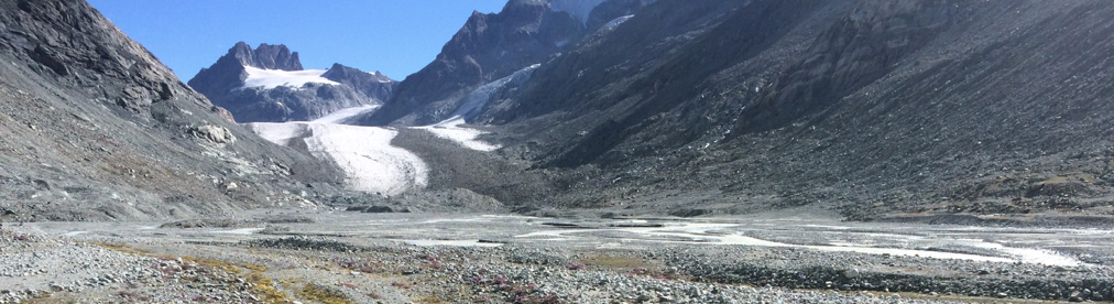
Recently, the combination of image acquisition with unmanned aerial vehicles (UAVs) and structure from motion (SfM) photogrammetry (Fig. 1) has been successfully applied to topographic reconstruction (Fonstad et al., 2013; James and Robson, 2012; Westoby et al., 2012) e.g. production of high-resolution digital elevation models (DEMs). Such technologies make the acquisition of data convenient, compared to traditional field surveying methods. However, after initial enthusiasm for the method, it has also been shown to lead to systematic errors in DEMs, such as “doming”, which are often particularly noticeable when DEMs are compared. Doming errors significantly affect the accuracy of topographic data. Whilst survey design determines the precision of the topographic data acquired and hence the changes in a surface that can be detected between two time periods, accuracy is a function of the extent to which the collinearity equations relating acquired imagery to the ground surface have been solved correctly. Inaccuracies may be minimized through effective survey design (e.g. in terms of the geometry of image acquisition or use of ground control points), eliminated through improved solution of the collinearity equations or corrected using post hoc modelling of error as a spatially dependent function (James et al., 2019).
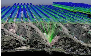
Figure 1. Reconstructed UAV-derived image positions and orientations in this study
Whilst some doming error can be reduced through survey design, the residual doming vertical error may remain (James and Robson, 2014). Moreover, adding control points is not practical for some scales of investigation. Doming errors are often due to error in the camera geometric model estimated during photogrammetric processing. In this part of the project I am aiming to develop robust processing methods for MVS-SfM analysis of UAV methods to detect gully erosion.
- The morphological method for gully erosion estimation
Gully erosion (Fig. 2), which widely threatens farmland and the environment, is a very serious type of water erosion (Castillo and Gómez, 2016; Poesen et al., 2003). Monitoring gully erosion is important, but traditional field survey is time-consuming. In this part of the project, I aim to use corrected DEMs to estimate DEMs of difference and to apply a two-dimensional morphological method (Antoniazza et al., 2019) to estimate the effects of gully erosion on sediment transport.
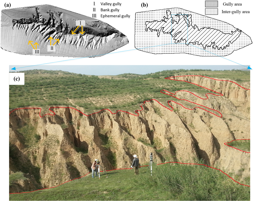
Fig. 2 Gully surveying using UAV and SfM-MVS photogrammetry (Dai et.al., 2019)
References
Antoniazza G, Bakker M, Lane S N. Revisiting the morphological method in two‐dimensions to quantify bed‐material transport in braided rivers[J]. Earth Surface Processes and Landforms, 2019.
Castillo, C., Gómez, J.A., (2016). A century of gully erosion research: urgency, complexity and study approaches. Earth Sci. Rev. 160, 300–319.
Dai, W., Yang, X., Na, J., Li, J., Brus, D., Xiong, L., … & Huang, X. (2019). Effects of DEM resolution on the accuracy of gully maps in loess hilly areas. Catena, 177, 114-125.
Fonstad M A, Dietrich J T, Courville B C, et al. Topographic structure from motion: a new development in photogrammetric measurement[J]. Earth Surface Processes and Landforms, 2013, 38(4): 421-430.
James M, Robson S. (2014). Systematic vertical error in UAV-derived topographic models: origins and solutions[J].
James, M. R., & Robson, S. (2012). Straightforward reconstruction of 3D surfaces and topography with a camera: Accuracy and geoscience application. Journal of Geophysical Research: Earth Surface, 117(F3).
James et, al (2019). Mitigating systematic error in topographic models for geomorphic change detection: Accuracy, precision and moving beyond off-nadir imagery, Earth Surface Processes & Landforms, In proceeding.
Poesen, J., Nachtergaele, J., Verstraeten, G., Valentin, C., (2003). Gully erosion and environmental change: importance and research needs. Catena 50, 91–133.
Tonkin, T. N., Midgley, N. G., Graham, D. J., & Labadz, J. C. (2014). The potential of small unmanned aircraft systems and structure from motion for topographic surveys: A test of emerging integrated approaches at Cwm Idwal, North Wales. Geomorphology, 226, 35-43.
Westoby M J, Brasington J, Glasser N F, et al. ‘Structure-from-Motion’photogrammetry: A low-cost, effective tool for geoscience applications[J]. Geomorphology, 2012, 179