Hydrological, geomorphological and ecosystem impacts of Alpine water intakes
PhD student Chrystelle Gabbud
Supervised by Professor Stuart Lane and co-supervised by Dr. Christopher Robinson
Part of the FNS NRP70 – Energy Turnaround called “Optimizing Environmental Flow Releases under Future Hydropower Operation” (HydroEnv), in collaboration between ETHZ (prof. P. Burlando), EPFL (prof. T. Battin) and EAWAG (dr. Christopher Robinson) and UNIL (prof. S. Lane).
This project addresses the hydrological, geomorphological and ecosystem impacts of Alpine water transfer systems in order to highlight the necessity of introducing sediment considerations into water intake law and to bring forward management suggestions.
Natural Alpine flow regimes are strongly modified by hydroelectric power production, which impacts upon both river discharge and sediment transfer systems, and in turn upon flora and fauna. These kinds of impacts are well studied where rivers are regulated by dams, with sediment retained behind walls and so sediment disconnection. There has been much less focus on water intakes (Figure 1) even though these may impact many more kms of stream than dams. The latter have a very smaller sediment storage capacity and thus have to flush sediment regularly in the form of purges (Figure 2), with high sediment concentrations for short durations. Purges do not eliminate sediment connectivity as sediment delivery is maintained, even if the transport capacity available for that sediment is reduced. High sediment transport rates and periodic bed disturbance impacts habitats, and may cause a clear ecological productivity and diversity decline. However, at present, the management of sediment is rarely considered in legislation designed to create more environmentally sustainable river flows. Where it is considered, it is concerned with reintroducing sediment, such as downstream of dams. Intakes deliver enough sediment, it is the impacts of their management that are simply not known.
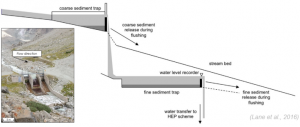
Figure 1: Water intake (here – Bertol Inférieur) and its typical scheme of sediment management through trap basins
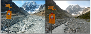
Figure 2: Channel before and during a (small) purge
Water management in Switzerland is currently facing a paradox. On the one hand, the country is committed to phasing out nuclear power by 2050, with the specific objective of increasing hydroelectric power by 10%. On the other hand, it is recognized that new measures must be taken for ecosystem improvement, in particular through the introduction of minimum flows downstream of infrastructures that reduce the water available for energy production. However, while these residual minimum flows have been proven in the case of dams, they are unlikely to meet the needs of water intake systems. Indeed, in Alpine environments, where “inherited” sediment delivery rates from upstream glaciers can be high, the problem lies in the competence of a stream to transport sediment. Minimum flows may not address this and so setting minimum flows without accompanying sediment management may simply reduce power production potential whilst leading to little ecosystem improvement.
The combination of drone imagery, a LiDAR ground-based laser scanner and archival image analysis allows creation of high precision elevation models (DEMs) (Figure 3a) through time for monitoring the hydrological and geomorphological impacts of these water transfer systems. These are being used to drive habitat models that take into account sediment transport. Monthly collection of aquatic organisms (macroinvertebrates) (Figure 3b) allowed identification and quantification of biotic communities and ecological responses to disturbance over the time.
Through the example of the Alpine catchment of the Borgne d’Arolla (VS), we show that the reduction of purges and thus disturbance frequency allows a rapid recolonization of macroinvertebrates in the system, thanks in particular to supply of organisms from the lateral tributaries.
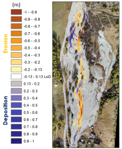
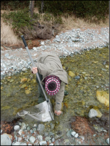
Figure 3: Methods: (a) Digital Elevation Model (DEM) of difference between June 2016 and October 2016 to see erosion (red) and deposition (blue) areas and amount and Ebee drone used to take pictures; (b) Macroinvetebrate sampling