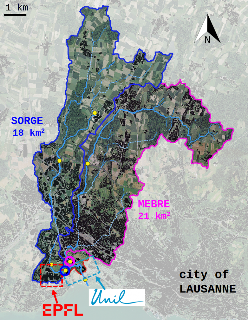
The Chamberonne River is located in the west of Lausanne in the Canton of Vaud. It is 23.5 km long and it is composed of the Sorge and the Mèbre tributaries. Its catchment has an area of about 40 km2 and is part of the broader Rhône River catchment. It has a mixed land use with a sharp transition from upper forested and agricultural areas to lower urban areas. The river flows through the EPFL and UNIL campuses before reaching Lake Léman. With a north-south flow, its catchment has the typical configuration of the Swiss Lemanic Rivers.
Challenges / Opportunities
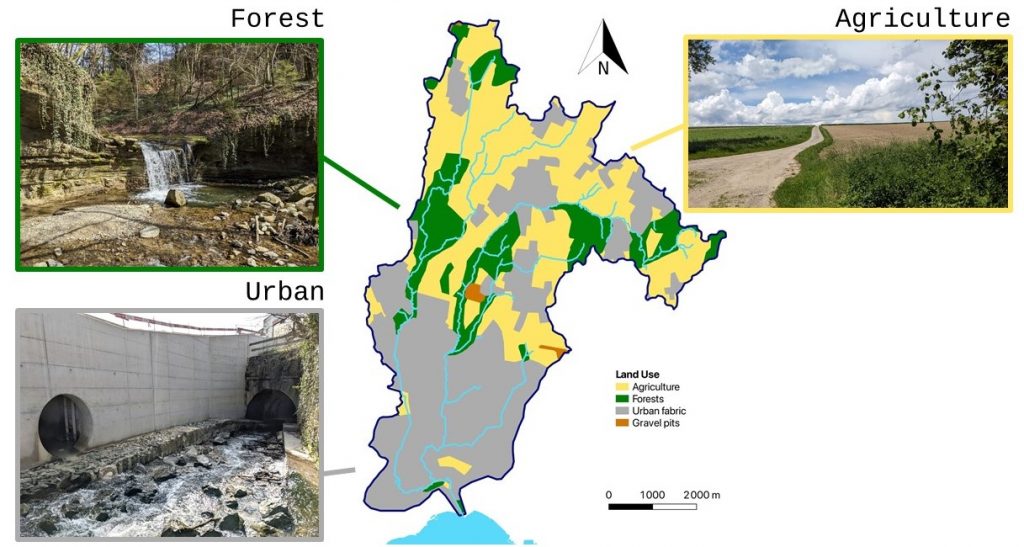
The Chamberonne is a compelling case study for water resources management because it encapsulates many of the major challenges faced by urban rivers: administrative responsibilities are shared across 13 municipalities; there is a sharp land use transition from forest and agriculture to urban (the urban surface increased by 11% in the period 1985-2018 and it’s been further increasing since then), resulting in the alternation of protected areas, naturalistic trails but also kilometers of river network channelized underground; water quality is often poor due to outdated hydraulic infrastructures, stormflow bypass systems often releasing untreated sewage water into the river during storms, and multiple unidentified point pollution sources. These challenges are common among many urban rivers in Switzerland and worldwide.
Because of these challenges, the Chamberonne is also at the center of two major initiatives carried out by the Canton of Vaud: the Plan régional d’évacuation des eaux (PREE) de la Chamberonne (whose development started in 2018 with the goals of improving the management of the Chamberonne drainage basin) and the Broye-Chamberonne renaturation project (https://broye-chamberonne.ch/ecf-chamberonne/), which will substantially modify the morphology of the river close to its mouth.
The proximity of the Chamberonne to the UNIL/EPFL campuses represents a unique opportunity for teaching, research and innovation. Many Environmental Science courses include excursions and activities on the Chamberonne and some are developed in collaboration with local associations. To facilitate exchanges and develop new ideas, an academic network around the Chamberonne has been created in spring 2025. Every person/group interested in collaborating and developing new projects is welcome to join this network.
Ongoing activities
Besides the major initiatives led by the Canton of Vaud, there exist various activities carried out by individual research groups at UNIL and EPFL. Some of them are listed below.
- The UNIL hydrology group (Paolo Benettin) has deployed sensors at 4 locations on the Mèbre and Sorge and a weather station on the Géopolis building. Weekly samples of rainwater and streamwater are also collected for chemical analyses since the Fall 2024. Ongoing master projects aim at sampling water and sediments during storm events.
- The Institute of Earth Surface Dynamics (IDYST) at UNIL operates a permanent station on the Chamberonne close to its mouth, with multiple sensors, cameras and an automated sampler permanently in place.
- The EPFL UrbanTwins project (Paolo Perona and Rizlan Bernier-Latmani) has deployed several sensors along the Sorge tributary to study the impact of EPFL campus on streamwater. The data is available online on the EPFL Water Portal.
- The UNIL group led by Céline Weyermann and previously by Nicolas Estoppey deployed passive samplers at many locations on the Chamberonne waters to identify point pollution sources along the river.
- The EPFL Ecotox Center (Benoît Ferrari, Carmen Casado Martinez, Rébecca Beauvais) participated in several ecotoxicology projects on the Chamberonne.
- The former EPFL ECHO lab (Andrea Rinaldo) used to operate 4 discharge gauging stations a meteo station on campus and a pluviometer and collected about 7 years of data from 2012 to 2019.
- The Swiss Federal Institute for Forest, Snow and Landscape Research (WSL) operates the Lausanne Forest station, as part of the Long-Term Forest Ecosystem Research (LWF) programme. The station is located within the national parc of Jorat, which is next to the east headwaters of the Chamberonne watershed.
- Many EPFL and UNIL courses include some field activities on the Chamberonne. For example, courses in: Geochemistry, Ecotoxicology, Solute transport, River Hydraulics, Environmental Geophysics, Water Resources Management.
- Many outreach activities for children and the general public are carried out on the Chamberonne by associations like L’éprouvette, Mycélium, Ville en tête, la Maison de la Rivière.
Publications
Journal articles / Reports
Pfeiffer, F., Tascon, I., Estoppey, N., Weyermann, C. (2024): Investigation des sources de pollutions aquatiques. In: Environnement et justice. Mélanges en l’honneur de la Prof. Anne-Christine Favre. Stämpfli Éditions SA Berne, 317-328, https://serval.unil.ch/notice/serval:BIB_6B00719280AA
Halder, J., Pralong, C., Bonvin, F., Lambiel, F., Vennemann, T. (2014) Application of δ18O, δ13CDIC, and major ions to evaluate micropollutant sources in the Bay of Vidy, Lake Geneva. Isot Environ Health Stud. 52 : 94–111. https://doi.org/10.1080/10256016.2014.971786
Rossi, L., Chesaux, L. (2013). Sources diffuses de micropolluants dans le Léman : Etude de bassins versants spécifiques et définition d’outils d’extrapolation. Rapport d’étude de l’EPFL, laboratoire de technologie écologique (ECOL), sur mandat de l’Office fédéral de l’environnement (OFEV). https://infoscience.epfl.ch/entities/publication/39e08516-4ca1-4f73-89d3-8d39b6993e2d/full
Bonvin, F., Chèvre, N., Rutler, N., Kohn, T. (2012) Pharmaceuticals and their human metabolites in Lake Geneva: occurrence, fate and ecotoxicological relevance. Archs. Sci. 65 : 143-156, https://doi.org/10.5169/seals-738357
MSc Theses
Borriero, A. (2020): Variability of major ion concentrations in the Mèbre river : field experiments and modeling. Master thesis, EPFL / Padova, ECHO.
Passera, L. (2019): Metal transport in the Chamberonne basin – focus on suspended solids. Master thesis, UNIL, IDYST.
Gyger, M. (2018): Seasonal contamination and biomagnification of polybrominated diphenyl ethers (PBDEs) in the river La Sorge. Master thesis, UNIL, IDYST.
Kjelberg, F. (2018): Quantification saisonnière de la contamination et de la bioamplification des polychlorobiphényles (PCB) le long d’une chaîne trophique d’eau douce : la rivière de la Sorge. Master thesis, UNIL, IDYST.
Trujillo Gomez, M. (2018): Quantifying fine particle transport in the Chamberonne. Master thesis, UNIL, IDYST.
Denervaud, A. (2017): Gauging the highs: design and realization of a water sampling campaign during high and low streamflow. Master thesis, EPFL, ECHO.
Broadhurst, M. (2014): Modèle hydrologique de prévision de débit pour le bassin versant de la Chamberonne. Master thesis, EPFL, ECOL.
Stalder, P. (2013): Hydrology and Pesticide Transport Modelling in the Petite Chamberonne catchment. Master thesis, EPFL, ECHO.
Muniz Miranda, G. (2012): Gestion intégrée des ressources en eau dans le bassin versant de la Mèbre-Sorge. Master thesis, UNIL, IGD.
Pralong, C. (2011): Utilisation du rapport isotopique du carbone inorganique dissous comme traceur environnemental du système aquatique de la baie de Vidy. Master thesis, UNIL, IDYST.
Semester Projects
Manetti, N. (2021): Data analysis of the Chamberonne river with R. Master project, EPFL, ECHO.
Steullet, L. (2018): Sampling stream water during a storm event. SIE project, EPFL, ECHO.
Fleury, L. (2017): Designing and conducting a water sampling campaign on the Mèbre River. SIE project, EPFL, ECHO.
Ficheux, L. (2016): Assessing the dilution effect in a river during storm events : Evolution of solute concentrations of the Sorge sampled during storm events. SIE project, EPFL, ECHO.
Séchaud, A. (2016): Designing and conducting a water sampling campaign on the Mèbre River. SIE project, EPFL, ECHO.
Le Roy, B. (2013): Calibration of an hydrology modelling in the Sorge catchment. SIE project, EPFL, ECHO.
Moal, O. (2013): Analyse des pesticides du bassin versant de la Chamberonne. SIE project, EPFL, ECHO.
Stalder, S. (2012): Identification des sources de pesticides agricoles dans le bassin versant de la Chamberonne. SIE project, EPFL, ECHO.
Sidler, J. (2012): Impacts de la station de pompage d’eau du lac de l’EPFL et de l’UNIL sur la Chamberonne. SIE project, EPFL, ECOL.
Imfeld, C. (2011): Calibration d’un modèle pluie-débit géomorphologique pour la Chamberonne. SIE project, EPFL, ECHO.
Schneider, K. (2009): Système modulaire gradué : État des lieux des données existant pour le bassin versant de la Mèbre et la Sorge. SIE, EPFL, ECOL.
BSc theses
Lambiel, F. (2010): Qualitative and quantitative water assessment of the Chamberonne River (Switzerland) on the basis of stable isotope compositions. Bachelor thesis, UNIL, IMG.
Interactive maps
The maps below shows the watershed (approximate boundaries based on topography) and the main gauging points along its network: